This item has been sold, but you can get on the Waitlist to be notified if another example becomes available, or purchase a digital scan.
1848 Purdy / Laurie Blueback Nautical Chart of Florida, Bahamas, West Indies
FloridaBahamas-purdy-1848$3,750.00

Title
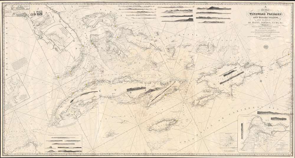
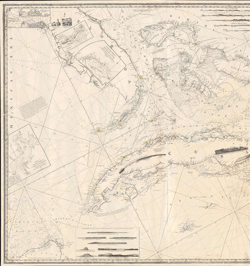
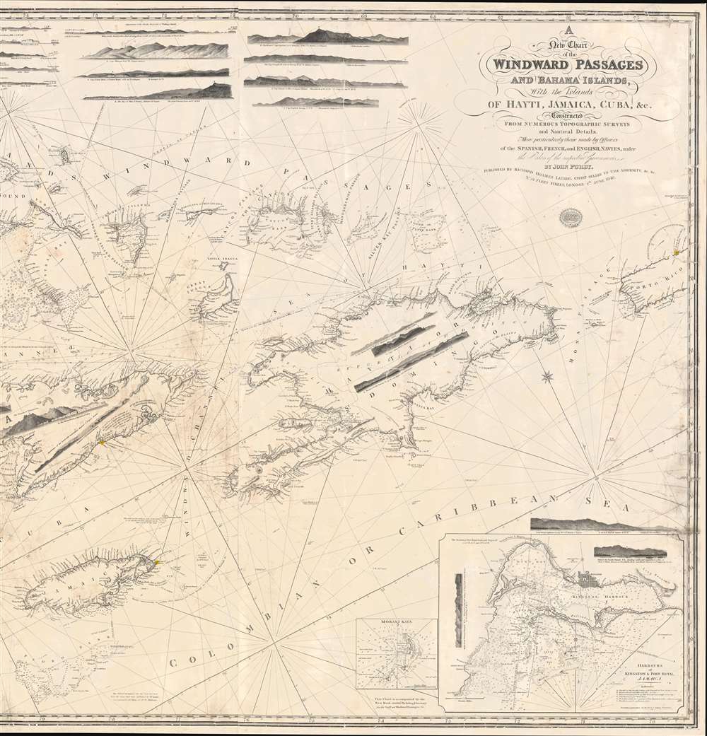
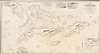
A New Chart of the Windward Passages and Bahama Islands, With the Islands of Hayti, Jamaica, Cuba, etc.
1848 (dated) 38 x 53 in (96.52 x 134.62 cm) 1 : 250000
1848 (dated) 38 x 53 in (96.52 x 134.62 cm) 1 : 250000
Description
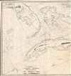
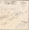
A rare and unusual 1848 John Purdy / Richard Holmes Laurie Blueback nautical chart or maritime map of Florida, the Bahamas, and the Greater Antilles - here in its only known surviving example. Oriented sharply to the northeast, the chart offers expansive coverage, embracing all of peninsular Florida, Cuba, the Bahamas, Hispaniola (Santo Domingo / Haiti), Jamaica, and Puerto Rico. The map exhibits some manuscript nautical annotations regarding lighthouses in the Bahamas and Cuba, but it is faded and unreadable. Insets detail important ports, including Havana, New Providence (Nassau), Matanzas, Guantanamo, the Morant Kays, and Kingston (Jamaica).
Curious Orientation
The northeasterly orientation may seem unusual, but is practical when considered in the context of the Windward Passage - the narrow and treacherous channel between Cuba and Hispaniola. With this orientation, the route through the passage is near vertical, allowing for ease of use when navigating northeasterly around Jamaica towards the Bahamas.Sources
To compile this map, Purdy, and later Laurie, drew from a variety of sources. Florida is based on British surveys conducted by William Gerard De Brahm from 1765 to 1772. The mapping of the Bahamian Archipelago and the Bahamas Bank is based on recent surveys conducted for the British Admiralty, including the work of Anthony De Mayne (1827), Richard Owen (1832) and Edward Barnett (1838). The Yucatan references the later 1844 Barnett survey. Jamaica is drawn from earlier Laurie charts. Cuba and Hispaniola draw on official Spanish charts by Don Ventura de Barcaizetegui (1793) and José de Rio Cosa (1804).Blueback Charts
Blueback nautical charts began appearing in London in the late 18th century. Bluebacks, as they came to be called, were privately published large format nautical charts known for their distinctive blue paper backing. The backing, a commonly available blue manila paper traditionally used by publishers to wrap unbound pamphlets, was adopted as a practical way to reinforce the low-quality paper used by private chart publishers trying to cut costs. However, not all blueback charts are literally backed with blue paper. The earliest known blueback charts include a 1760 chart issued by Mount and Page, and a 1787 chart issued by Robert Sayer. The tradition took off in the early 19th century, when British publishers like John Hamilton Moore, Robert Blachford, James Imray, William Heather, John William Norie, Charles Wilson, David Steel, R. H. Laurie, and John Hobbs, among others, rose to dominate the chart trade. Bluebacks became so popular that the convention was embraced by chartmakers outside of England, including Americans Edmund March Blunt and George Eldridge, as well as Scandinavian, French, German, Russian, and Spanish chartmakers. Blueback charts remained popular until the late 19th century, when government subsidized organizations like the British Admiralty Hydrographic Office and the United States Coast Survey, began issuing their own superior charts on high quality paper that did not require reinforcement.Publication History and Census
We find some evidence that this map was first engraved in 1844, but an even earlier edition may have been made, as Purdy died in 1843. There are references to a map with a similar title by Purdy dated to 1811, but no surviving example is known - leaving a good chance that it is an entirely different map. We find an 1852 example at the Maritiem Museum Rotterdam, and vague references to editions as late as 1861. The present 1848 example is the earliest known in any collection.CartographerS
John Purdy (August 14, 1773- January 29, 1843) was a British cartographer and hydrographer active London during the early part of the 19th century. Purdy was born in Norwich, the son of a tailor, and apprenticed to David Steel of the Stationers Guild on December 1 of 1795. After his apprenticeship Purdy partnered with Henry Cooper to establisher an independent map and chart selling business. This business failed to turn a profit and was dissolved with bankruptcy hearings in November of 1811. From about 1812 onwards Purdy took over Delarochette's hydrographer position for the firm of Laurie and Whittle. The remainder of his work is associated with this firm. Like most map publishers Purdy did not personally take part in expeditions, but he exhibits a great talent for synthesizing the work of others. Among his more important accomplishments are the great Cabotia map of Canada, the identification of Rennell's Current, and the publication of Rennell's wind charts. He was considered the foremost British hydrographer of his era. Purdy died of gangrene on January 29 of 1843. More by this mapmaker...
Richard Holmes Laurie (December 2, 1777 - January 19, 1858) was a British map and chart publisher and seller. Born in London to publisher Robert Laurie and his wife Esther Jouret, R. H. Laurie took over his father's share of the Laurie and Whittle publishing firm upon his father's retirement in 1812 and began trading as Whittle and Laurie. After Whittle died in 1818, Laurie continued the business by himself, trading under the imprint R. H. Laurie. During the 1820s and 1830s, Laurie expanded the nautical chart business until he was overtaken by Admiralty charts. Laurie married Susan Ann Coates on February 6, 1814 and later married Mary Ann Dennison on October 15, 1833. He left his business and all his property in trust for his two surviving daughters (both of whom were minors) with his principal engraver, Alexander George Findlay. Findlay continued the business in Laurie's name after acquiring its equity from his daughters. Learn More...
Condition
Very good. Relaid on fresh linen. Some repair tears and edge damage.