
1926 Poole Brothers Atlas of Florida and the Gulf Coast, w/ Cuba

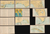
Map of Florida and the Gulf Coast including the territory from New Orleans to Havana.
Chicago to Cuba, and Everywhere in Between.
- Digital Map Information
- Suitable for large format printing
- File Size: 127.29 MB
- File Type: ZIP / TIFF
- ICC color profile embedded
- Delivered instantly via download link
Chicago to Cuba, and Everywhere in Between.
This is a 1926 map booklet or loose-leaf atlas of Florida, the Gulf Coast, and Cuba, prepared by Poole Brothers. It is designed to promote the 'Dixie Flyer,' a collaborative enterprise between three railroad companies that offered luxurious sleeper train service between Chicago and Jacksonville, with stops in St. Louis, Atlanta, and other cities.A Closer Look
The map pages of the atlas cover the Gulf Coast from New Orleans, through Florida, to Cuba in seven sections, laid out in an index sheet. Cities and towns are noted throughout with state and county boundaries, but the focus is on railroads and associated steamship lines. In particular, the 'Dixie Flyer' route connecting Chicago to Florida via Atlanta (presented in a map opposite the index map), combines portions of the Chicago and Eastern Illinois Railway, the Louisville and Nashville Railroad, and the Nashville, Chattanooga, and St. Louis Railroad. The southern terminus of the Dixie Flyer was Jacksonville, but from there, passengers could link up with the Florida East Coast Railway or the Atlantic Coast Line for destinations south. The latter pages of the booklet contain an extensive index of cities and stations, listing the map number and grid coordinates where they appear.The 'Dixie Flyer'
The Dixie Flyer began service in 1892 as a premier passenger train designed to connect the Midwestern United States with the Florida coast. Operated primarily through a cooperative effort between the Chicago and Eastern Illinois, the Louisville and Nashville, and the Nashville, Chattanooga, and St. Louis railroads, the service was a response to the growing demand for tourism in the Sunshine State. By the turn of the century, it had established a reputation for speed and reliability, whisking travelers from the chilling winds of Chicago into the tropical warmth of Jacksonville.As the Florida Land Boom of the early 1920s took hold, the Dixie Flyer entered its golden era of expansion and prestige. By 1925, the service had become so popular that it was often run in multiple sections to accommodate the sheer volume of passengers moving toward the developing Florida real estate market. To maintain its competitive edge against rivals like the Royal Palm, the railroads invested heavily in infrastructure, replacing older wooden equipment with all-steel heavyweight cars and powerful Pacific-type steam locomotives. But the collapse of the Florida Land Boom and the Great Depression greatly hampered demand for the service, and passenger numbers continued to drop. Nonetheless, the 'Dixie Flyer' continued to run until 1965 and, in an abbreviated form (between Atlanta and Jacksonville), until 1969.
Publication History and Census
This booklet was prepared by the firm Poole Brothers in 1926. It is quite rare, only appearing in three institutional collections: at the University of Virginia (in the 'Southern States' Pamphlet Collection: Alabama'), at the University of Florida, and at the Tampa Bay History Center's Touchton Map Library.Cartographer
Poole Brothers (1878 - 1968) were a Chicago based firm active in the late 19th and early 20th century with an initial focus on promotional railroad maps. Poole Brothers was founded by George Amos Poole (March 20, 1843 – September 7, 1918). In 1868, Poole, along with his uncle William H. Rand (1828 - 1915) and Andrew McNally (1836 - 1904), purchased the Chicago Tribune's job printing plant and formed the firm Rand McNally. In 1878, he left Rand McNally to form, with his brother William H. Poole, Poole Brothers, a direct competitor to Rand McNally for the lucrative railroad business. Like many of its competitors, Poole Brothers maintained an office on Chicago's Printer's Row (downtown Loop district). Their earliest known work is an 1880 map of Yellowstone National Park. In 1887, Poole Brothers, Andrew McNally, and several others formed the United Typothetae of America, a master printers association. In 1848, they were cited, along with Rand McNally and George Cram, by the Federal Trade Commission for price fixing. Their earliest known work is an 1880 map of Yellowstone National Park. Afterward they went on to produce a vast range of maps and other print products including tickets, cards, coupons, and restaurant menus. In time Poole Brothers merged with Newman-Randolph, which was then acquired by the American Can Company in the early 1960s. The American Can Company liquidated its printing concerns later in the same decade. Further Details...
Condition
Very good. Slight wear on old fold. Some old staple damage. Staples missing. Individual sheets measure 9 x 16 in.
References
OCLC 844960983. University of Florida, Map Number M1.1926.003.2011.1322. Touchton Map Library Accession Number: L2019.059.026.