This item has been sold, but you can get on the Waitlist to be notified if another example becomes available, or purchase a digital scan.
1845 Morse and Breese Maps of Florida and New York
FloridaNewYork-morse-1845$250.00

Title
Florida. / New York and Vicinity.
1845 (dated) 16 x 13 in (40.64 x 33.02 cm) 1 : 2000000
1845 (dated) 16 x 13 in (40.64 x 33.02 cm) 1 : 2000000
Description
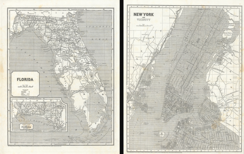
Maps of the Florida and New York City in 1845, issued for Sidney E. Morse's Cerographic Atlas. The maps are printed back-to-back. The more significant of the two maps, depicting Florida, captures the state as it emerged from the Second Seminole War and the United States solidified its control over the territory.
In 1842, Florida, a land of swamps, dense forests, and a sprawling coastline, was transitioning from its Spanish colonial past to an American frontier territory. The end of the Seminole Wars that year led to the forced removal of most of the Seminole population, solidifying U.S. control over the region. The Armed Occupation Act was enacted by the U.S. Congress to incentivize settlement, granting land to settlers who would commit to bear arms and establish residences in the territory. These changes marked the beginning of rapid American colonization, bringing an influx of settlers drawn by the allure of its mild climate, agricultural potential, and strategic location. Yet, amidst these changes, the state's unique blend of Spanish, Native American, and African influences continued to shape its cultural and social fabric.
Florida (1:2000000)
The map depicts Florida at the end of the Second Seminole War (1835 - 1842). Coverage ranges from the Apalachicola River to the Atlantic Ocean and from Georgia to the Straits of Florida and the Florida Keys. Cities, towns, and villages are identified, including Tallahassee and St. Augustine. Limited roads and a rich network of rivers traverse the state. Several battles from First and Second Seminole Wars are noted. An inset map in the lower left corner depicts the western panhandle from the Apalachicola River to Alabama and from Alabama to the Gulf of Mexico.In 1842, Florida, a land of swamps, dense forests, and a sprawling coastline, was transitioning from its Spanish colonial past to an American frontier territory. The end of the Seminole Wars that year led to the forced removal of most of the Seminole population, solidifying U.S. control over the region. The Armed Occupation Act was enacted by the U.S. Congress to incentivize settlement, granting land to settlers who would commit to bear arms and establish residences in the territory. These changes marked the beginning of rapid American colonization, bringing an influx of settlers drawn by the allure of its mild climate, agricultural potential, and strategic location. Yet, amidst these changes, the state's unique blend of Spanish, Native American, and African influences continued to shape its cultural and social fabric.
New York and Vicinity (1:44000)
The map covers most of Manhattan, to about 134th Street, as well as most of northern Brooklyn, the developed parts of Queens, including Ravenwood and Astoria, as well as Jersey City and Hoboken.Publication History and Census
Both maps were engraved in 1842, likely by J. N. Nicollet. They were published in the 1845 edition of Morse and Breese's Cerographic Atlas of the United States - the first atlas printed the revolutionary cerographic process (wax engraving). The map is scarce but appears occasionally on the market.CartographerS
Sidney Edwards Morse (February 7, 1794 - December 24, 1871) was an American geographer, journalist, and inventor. Born in Charlestown, Massachusetts, Morse was the son of the geographer and clergyman Jedidiah Morse (August 23, 1761 - June 9, 1826) and his wife Elizabeth Ann Finley Breese. Morse graduated from Yale in 1811, and also studied theology at Andover Seminary, as well as law at the school in Litchfield, Connecticut. Morse moved to New York City in 1823, where he founded the New York Observer with his brother Richard Cary Morse (1795 - 1868). Together with Henry A. Munson he developed cerography, a printmaking technique using a layer of wax over a metal substrate. Morse used this technique to illustrate his geographical textbooks, including the The Cerographic Atlas of the United States, which he co-published with Samuel Breese. Morse devoted his last few years to experimenting with an invention, called a bathyometer, created to aid in the rapid exploration of the ocean. His invention was exhibited in Paris during the 1869 World's Fair and the following year in New York City. More by this mapmaker...
Samuel Breese (September 27, 1802 - October 14, 1873) was an American cartographer who co-published The Cerographic Atlas of the United States with Sidney Edwards Morse. Learn More...
Source
The Cerographic Atlas Of The United States, (New York: Sidney E. Morse) 1845.
Morse and Breese's Cerographic Atlas of the United States, also known as Morse's North American Atlas was a landmark in American Cartography, being the first atlas to employ the cerographic (wax process) printing. Cerography was a wax process invented in the late 1830s by Sidney E. Morse, the son of Jedediah Morse (1761 - 1826), who immediately recognized its value for map publication. The maps were first printed in a series of inserts in the New York Post, then later as sets in three fascicles, then in two atlas issues in 1845.
Condition
Very good. Slight margin stains. Maps printed back to back.
References
Rumsey, 4180.014, 4180.013.