
This item below is out of stock, but another example (left) is available. To view the available item, click "Details."
Details
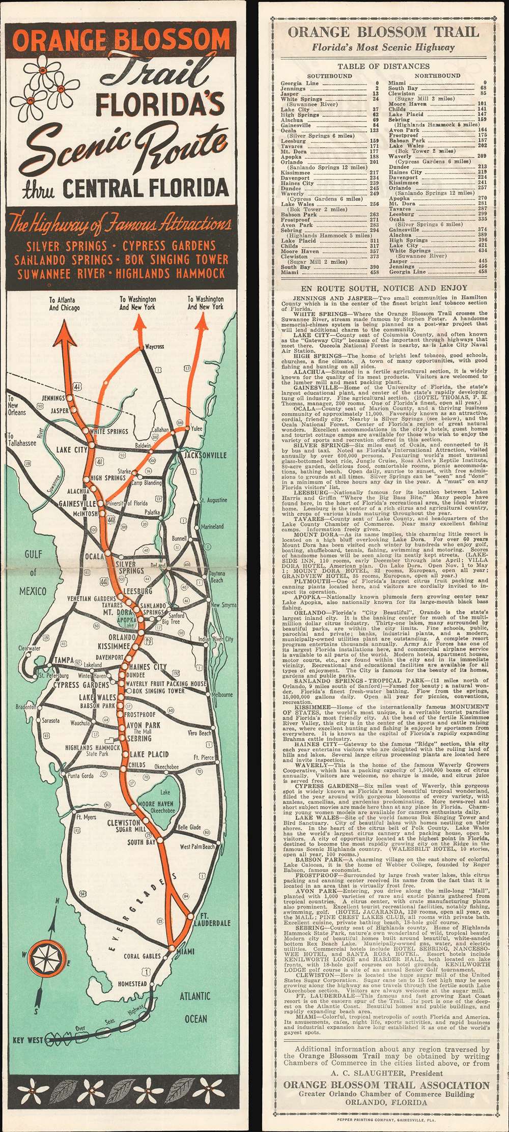
1950 Orange Blossom Trail Association Highway Map of Florida
$150.00
1950 Orange Blossom Trail Association Highway Map of Florida
FloridaOrangeBlossom-trailassociation-1950$50.00

Title
Orange Blossom Trail. Florida's Scenic Route thru Central Florida.
1950 (undated) 18.25 x 4 in (46.355 x 10.16 cm) 1 : 2500000
1950 (undated) 18.25 x 4 in (46.355 x 10.16 cm) 1 : 2500000
Description
This is a c. 1950 Orange Blossom Trail Association highway map of Florida. The Orange Blossom Trail, highlighted in orange, traveled through central Florida and carried tourists from all over the country to visit places like the Bok Tower, Cypress Gardens, and Silver Springs. Many of these sites are detailed on the verso, with short paragraphs providing glimpses of what tourists could expect in each one. Apparently, the Orange Blossom Trail got its name from a famous train, the 'Orange Blossom Special', which inspired a song by the same name written by Ervin Rouse and Chubby Wise. It became one of the most popular bluegrass songs of the 20th century, and, in 1965, Johnny Cash recorded one of the finest versions.
Publication History and Census
This map was created for the Orange Blossom Trail Association and was printed by the Pepper Printing Company of Gainesville, Florida. Maps of the Orange Blossom Trail are popular with collectors and are scarce on the private market.Cartographer
The Orange Blossom Trail Association (1934 - 197x) was an association founded in Florida to promote tourism along a 'scenic central route through Florida'. The Association promoted hotels and attractions along the highway and provided booklets describing them free of charge. It is unclear when the association was disbanded. More by this mapmaker...
Condition
Very good. Map exhibits slight centerfold wear. Image presents both front (recto) and back (verso) of the map.