
1892 Elliott Promotional Map of Florida, 'Plant System'

This item has been sold.
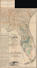
Township Map of Peninsular Florida. / Florida Map Illustrating its Geographical Position and showing Routes of the 'Plant System' of Railway and Steamship Lines / Map Showing the Lands of the Associated Railway Land Department of Florida.
Impressive Reach of the Plant System in Florida.
- Digital Map Information
- Suitable for large format printing
- Full resolution TIFF file
- ICC color profile embedded
- Delivered instantly via download link
Impressive Reach of the Plant System in Florida.
This is an 1892 promotional map of Florida, prepared by David H. Elliott of the Associated Railway Land Department of Florida, and printed by Matthews, Northrup, and Company. While promoting Florida generally, it specifically highlights the railways, steamship lines, and lands of the Plant System (railroads), a major player in Florida's land and investment boom at the time.A Closer Look
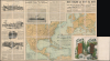
The map presents Florida along with portions of southern Georgia and Alabama, with county boundaries, waterways, and railway and steamship lines traced. Cities, towns, forts, and other features are recorded throughout, as are survey lines. The lands belonging to the Associated Railway Land Department of Florida are shaded green, spanning the entire state, from Nassau County in the north to Lee County in the south. The text at the bottom-left discusses the booming phosphate industry in Florida, which was as important as the citrus industry in attracting investment and visitors to the state. At the bottom is a set of vignette illustrations of Florida hunting and fishing scenes.The verso contains maps of eastern North America, the Caribbean, and Western Europe, focusing on rail and steamer connections, particularly those of the Plant System. Photographs and text promote the hotels, tours, and mail service offered by the Plant System, including the luxurious Seminole Hotel in Winter Park and the Tampa Bay Hotel.
Historical Context
In the late 19th century, Florida's breakneck development was driven by the land departments of private transportation syndicates, most notably the Plant Investment Company. Following the American Civil War (1861 - 1865), the state's Internal Improvement Fund was heavily indebted, leading to the sale of public lands to wealthy developers who promised to build infrastructure. Henry B. Plant leveraged these conditions to acquire millions of acres of land as subsidies for every mile of track his company laid. These land development departments served as the region's primary architects, meticulously surveying the wilderness to establish new townships, agricultural colonies, and commercial hubs that turned Florida's wetlands into high-value real estate.The success of these development efforts was entirely dependent upon their integration with the Plant System. The land department's strategy was a classic example of vertical integration: the railroads provided physical access to the interior, while the steamship lines opened international trade routes for the citrus and phosphate produced on the developed land. By coordinating these transportation schedules, the Plant System ensured that any land it sold was backed by a reliable logistics chain. This synergy culminated in the construction of opulent 'destination hotels,' such as the Tampa Bay Hotel, which served as the crown jewels of the land department's holdings, effectively marketing Florida as a luxury winter playground and ensuring the long-term appreciation of the surrounding acreage.
The Plant System
The Plant System, named after its owner, Henry B. Plant (1819 - 1899), was a network of railroads and steamboats in the U.S. Southeast. The system was based on the Savannah, Florida and Western Railway, running across southern Georgia. The Plant Investment Company was formed in 1882. It expanded coverage by leasing or acquiring other railroads, including the Charleston Railroad and the Brunswick and Western Railroad. It also began acquiring steamship lines, extending coverage from Tampa to Cuba, Key West, and other points. In its later years, the Plant system competed with Henry Flagler's Florida East Coast Railroad. It was taken over by the Atlantic Coast Line Railroad in 1902.Publication History and Census
This map and booklet were prepared by Matthews, Northrup, and Company in 1892 for the Associated Railway Land Department of Florida. At least three editions were published: in 1890, the present 1892 edition, and a 1897 edition. The present edition does not appear to be cataloged at any institution, while the other editions are cataloged at approximately 15 institutions, including the David Rumsey Historical Map Collection and the Tampa Bay History Center's Touchton Map Library.Cartographers
David H. Elliott (c. 1840 - September 30, 1900), a.k.a. 'Colonel', was a leading figure in the agricultural community, a journalist, a railway agent, and an all-around 'booster' active in Florida and the southeastern U.S. in the late 19th century. Details of his biography are scant but he appears to have been born in Alabama and likely served in the U.S. Civil War on the side of the Confederacy, resulting in his commonly used title, Colonel. Elliott founded the agricultural periodical The Florida Dispatch in the 1870s, and afterwards became associated with the Plant System of railroads, often touring with potential land buyers around the state and traveling to other states to promote Florida as a destination for investment and settlers. Perhaps most impressively, he commissioned a colossal map of Florida's phosphate lands for the 1895 Cotton States and International Exposition in Atlanta Georgia. The map consisted of ten sheets, each 4.5 x 10 feet in size, resulting in a map covering 900 square feet of wall space when joined. He served as the General Land Agent of the Plant-affiliated Associated Railway Land Department of Florida for much of the 1890s. He also was for many years the secretary and treasurer of the Florida Press Association, and also served as secretary of the Florida Fruit-Growers Association and Chairman of the Committee of Transportation of the Florida Horticultural Society. After working for the Plant System, Elliott managed the Florida Dispatch Line, a freight railway that primarily handled produce bound for northern markets. At the time of his death, Elliott was working as Land Agent for the Southern Railway in Charleston, South Carolina. Further Details...
Matthews-Northrup Works (fl. c. 1895 - 1930) were a Buffalo, New York based, in their own words, "writing, designing, engraving, printing, [and] binding" firm. The firm was founded by James Newson Matthews (November 21, 1828 - December 20, 1888) as the J. N. Matthews Company. William Phelps Northrup (April 2, 1850 - February 2, 1929) later joined the company as an apprentice and then partner, at which point the firm was reincorporated as the Matthews-Northrup Works. The Matthews-Northrup Works rose to prominence as publishers and printers of railroad maps, with dozens to their credit. When James died, his shares were inhered by George Edward Matthews (1855 - 1910), who ran the business until his death in 1910. Also in 1910, they famously redesigned the cover of National Geographic Magazine. Despite some six previous cover changes in just 21 years, the Matthews-Northrup layout proved so popular that it was used for nearly 50 years. The firm can also take credit for the Winchell typeface, designed in 1903 under E. E. Winchell's tenure as art director. Curiously, the partners of Matthews-Northrup maintained an unusual affectation in which only the officers of the company could wear beards or mustaches. In this same spirit, the firm also had its own private social club, the Fellowcraft Club, where the all-male employees could relax, play pool, drink and dine. Matthews-Northrup maintained offices on Washington Street, Buffalo, where they were based, as well as Madison Square, New York City, Garden Tower, Boston, and the Citizens Building in Cleveland. Further Details...
Condition
Good. Wear along original fold lines. Verso repairs and reinforcements along original fold lines and at fold intersections. Map of North America and Western Europe on verso. Attached to binder.
References
Rumsey 4100.001 (1890 edition). Touchton Map Library Accession Number: 2018.120.016 (1896 edition). OCLC 53000105, 28087748 (multiple editions, though not the present one).