This item has been sold, but you can get on the Waitlist to be notified if another example becomes available, or purchase a digital scan.
1861 Mitchell Map of Florida and South Carolina
FloridaSouthCarolina-mitchell-1861$100.00

Title
County Map of Florida. / Map of South Carolina.
1860 (dated) 11 x 14 in (27.94 x 35.56 cm) 1 : 3600000
1860 (dated) 11 x 14 in (27.94 x 35.56 cm) 1 : 3600000
Description
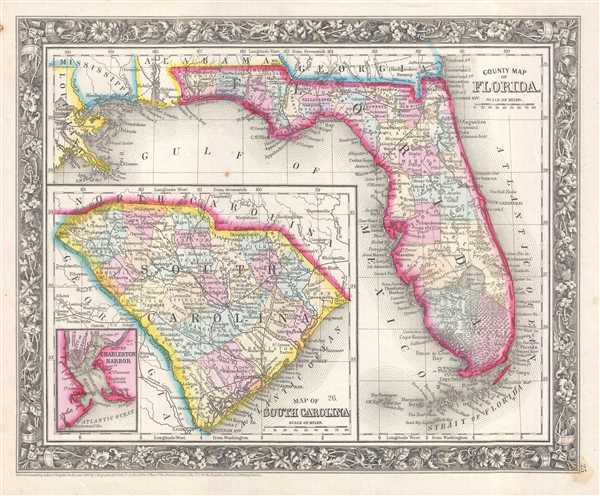
This is an 1861 Samuel Augustus Mitchell, Jr. map of Florida and South Carolina on one sheet. The map depicts the region surrounding the state of Florida from eastern Louisiana to the Atlantic Ocean and from Georgia and Alabama to the Strait of Florida. South Carolina, which is situated in the lower left quadrant, is illustrated from Georgia to the Atlantic Ocean and from North Carolina to Savannah, Georgia. Individual counties are illustrated, labeled, and shaded different colors to allow for easy differentiation in both Florida and South Carolina. Cities, towns, and villages are labeled in both states as well. Florida's nascent rail network is illustrated, with completed routes only in the northern part of the state, one of which connects Tallahassee with Jacksonville. A spur line between St. Marks and Tallahassee also appears to be in service, allowing cargo to be shipped from Appalachie Bay to Tallahassee.
The rail network in South Carolina is much more extensive than the one in Florida, and the South Carolina Railroad and the Northeastern Railroad. The Northeastern was only completed in 1856 and connected Charleston, South Carolina with Florence, South Carolina. The Georgia Central Railroad, which connected with the South Carolina Railroad at Augusta, Georgia and Hamburg, South Carolina (located across the Savannah River from each other) is also illustrated. An inset map of Charleston Harbor is also present in the lower left corner of the South Carolina map. This map labels numerous locations in the vicinity of the city of Charleston, including Fort Sumter (Fort Sumpter), where the first shots of the American Civil War were fired on April 12, 1861.
This map was prepared by S. A. Mitchell Jr. for inclusion in the 1861 edition of Mitchell's New General Atlas. Like many American map publishers of this period, Mitchell did not regularly update his copyrights, consequently this map is dated and copyrighted to 1860: 'Entered according to Act of Congress in the Year 1860 by S. Augustus Mitchell Jr. in the Clerk's Office of the District Court of the U.S. for the Eastern District of Pennsylvania.'
Cartographer
Samuel Augustus Mitchell (March 20, 1792 - December 20, 1868) began his map publishing career in the early 1830s. Mitchell was born in Bristol, Connecticut. He relocated to Philadelphia in 1821. Having worked as a school teacher and a geographical writer, Mitchell was frustrated with the low quality and inaccuracy of school texts of the period. His first maps were an attempt to rectify this problem. In the next 20 years Mitchell would become the most prominent American map publisher of the mid-19th century. Mitchell worked with prominent engravers J. H. Young, H. S. Tanner, and H. N. Burroughs before attaining the full copyright on his maps in 1847. In 1849 Mitchell either partnered with or sold his plates to Thomas, Cowperthwait and Company who continued to publish the Mitchell's Universal Atlas. By about 1856 most of the Mitchell plates and copyrights were acquired by Charles Desilver who continued to publish the maps, many with modified borders and color schemes, until Mitchell's son, Samuel Augustus Mitchell Junior, entered the picture. In 1859, S.A. Mitchell Jr. purchased most of the plates back from Desilver and introduced his own floral motif border. From 1860 on, he published his own editions of the New General Atlas. The younger Mitchell became as prominent as his father, publishing maps and atlases until 1887, when most of the copyrights were again sold and the Mitchell firm closed its doors for the final time. More by this mapmaker...
Source
Mitchell, S. A., Mitchell's New General Atlas Containing Maps of the Various Countries of the World, Plans of Cities, Etc., embraced in Forty-Seven Quarto Maps, Forming a series of Seventy-Six Maps and Plans, together with Valuable Statistical Tables (Philadelphia: S. Augustus Mitchell, Jr.) 1861.
Mitchell's New General Atlas was published by Samuel Augustus Mitchell, Jr., the son of the prolific cartographer Samuel Augustus Mitchell. Many of the plates are derived from the his father's Mitchell's Universal Atlas, but not directly. The Mitchell's Universal Atlas was initially sold to Thomas, Cowperthwait, and Company in 1849, and again to Charles Deliver in 1856. It was Deliver who introduced the new vibrant color scheme, abandoning the older Mitchell's Universal Atlas green borders and themes for bright reds, blues, and yellows. Samuel Augustus Mitchell, Jr. acquired the Deliver plates in 1859. He added his own floral motif border, but doubled down on the vibrant color scheme, thus introducing to the American public the most vividly colored American atlas of the 19th century. In 1860, he published the first edition of his New General Atlas and, despite a slump in sales during the American Civil War, attained a level of success to rival his father. Mitchell would continue to publish the New General Atlas until 1887, when the firm formally closed.
Condition
Very good. Even overall toning. Light foxing and soiling. Blank on verso.
References
Rumsey 0565.018 (1860 edition).