
1963 Florida State Turnpike Authority Map of the Florida Turnpike

This item has been sold.
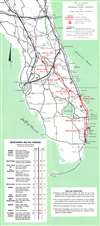
Map of Florida Showing Sunshine State Parkway and Other Principal Highways.
Planned extension of the Florida Turnpike.
Choose a Collection:
This Item
Enquire
Planned extension of the Florida Turnpike.
This is a c. 1963 Florida State Turnpike Authority map of the Florida Turnpike. A thick red line highlights the Florida Turnpike from Miami north to Fort Prince. Squares with diamonds mark service stations and circles with lines mark interchanges. A red dashed line highlights the Wildwood Extension, which was scheduled to open on January 1, 1964. Thick black lines mark highways that had been completed or would be finished by January 1964 as of the publication of this map, while the thin black lines trace existing highways across the state. The black dotted line extending north from Fort Pierce along the Atlantic coast to Daytona Beach marks a section of highway not scheduled to be completed until at least December 1972.Publication History and Census
This map was created for and published by the Florida State Turnpike Authority c. 1963. We have been unable to locate any other cataloged examples.Condition
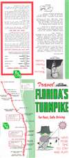
Very good. Exhibits light wear along original fold lines. Text on verso.