1921 Crow City Plan or Map of the Foreign Settlements, Shanghai, China
ForeignSettlementsShanghai-crow-1921$200.00

Title
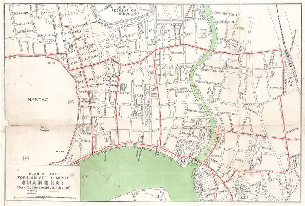
Plan of the Foreign Settlements Shanghai. Drawn for Crow's 'Handbook for China'.
1921 (undated) 9.25 x 13.75 in (23.495 x 34.925 cm) 1 : 12000
1921 (undated) 9.25 x 13.75 in (23.495 x 34.925 cm) 1 : 12000
Description
This is a c. 1921 Carl Crow city plan or map of part of the International Settlement in Shanghai, China. With the Huangpu River and the world-famous Shanghai Bund near the bottom border, the map depicts part of the British and French concessions. Streets are labeled throughout, along with the public recreation ground, several churches and cathedrals, hotels, the customs house, and the Shanghai Club. The British Consulate is identified as are the French municipal offices and the French Consulate.
Lining the Huangpu River, the Shanghai Bund has dozens of historical buildings that once housed important banks and trading houses from the United Kingdom, France, United States, Italy, Russia, Germany, Japan, Netherlands and Belgium, as well as the consulates of Russia and Britain, a newspaper, the Shanghai Club and the Masonic Club. The Bund lies north of the old walled city of Shanghai and was initially a British settlement. A building boom at the end of the 19th century and the beginning of the 20th century led to the Bund becoming the major financial hub of East Asia. The former French Bund, east of the walled city was formerly more a working harbor.
The Bund
The Bund is a waterfront area in central Shanghai. The name is derived from the old German term, 'bund,' meaning simply embankment or causeway. Many Asian colonial cities supported a Bund, but none became more famous or iconic than the Shanghai Bund. The area centers on the section of Zhongshan Road within the former Shanghai International Settlement, which runs along the western bank of the Huangpu River, facing Pudong, in the eastern part of Huangpu District. The Bund usually refers to the buildings and wharves on this section of the road, as well as some adjacent area. It is one of the most famous tourist destinations in Shanghai and a designated historic zone.Lining the Huangpu River, the Shanghai Bund has dozens of historical buildings that once housed important banks and trading houses from the United Kingdom, France, United States, Italy, Russia, Germany, Japan, Netherlands and Belgium, as well as the consulates of Russia and Britain, a newspaper, the Shanghai Club and the Masonic Club. The Bund lies north of the old walled city of Shanghai and was initially a British settlement. A building boom at the end of the 19th century and the beginning of the 20th century led to the Bund becoming the major financial hub of East Asia. The former French Bund, east of the walled city was formerly more a working harbor.
Shanghai International Settlement
The Shanghai International settlement was created in 1863 when the British and American Shanghai enclaves merged. These concessions had been granted to England and the United States as part of the Unequal Treaties that followed the Opium Wars. From about 1854 the settlements were governed by the Shanghai Municipal Council, a British dominated board of government officials and powerful merchants. The board issued restrictions limiting Chinese habitation on International Settlement territory and oversaw the construction of public services, including Trams, a sewage system, highways, and port buildings. The International settlement expanded several times in the late 19th and early 20th century. It became an enclave of peace and prosperity when the Japanese invaded Shanghai in 1837 but this abruptly came to an end with the Japanese bombing of Pearl Harbor and subsequent invasion of the International Settlement in 1941. After the war the International Settlement lands were returned to Chinese sovereignty.Shanghai 1910 - 1932
The 1910s-20s were a golden age for Shanghai, at least in the Concessions. While China was ruled by Chiang Kai-shek, Shanghai was dominated by several consolidated foreign trade Concessions. Under the strict administrative control of the Concessions, the city became a cosmopolitan haven in the midst of political unrest and a center for global trade and finance. The Concessions occupied what is today central Shanghai's most desirable land, hugging the Huangpu River and Wusong River (Suzhou Creek). These extraterritorial European, Japanese, and American enclaves had modern housing, fine roads, streetcars, elegant shops, clubs, and more. It was a place of excess, art, and extravagance, where fortunes could be made by the enterprising - and lost by the foolish. Moreover, lacking the moral constrains that limited social life in Europe and America, Shanghai became nexus for the opium trade, sexual excess, gambling, and other vices. This ephemeral world come crashing down on January 28, 1932, when the 'Shanghai Incident' or 'January 28 Incident' pitted the Republic of China against the Empire of Japan. Responding to Chinese student protests against the Japanese occupation of Manchuria, the Japanese Navy bombarded Shanghai. Chiang Kai-shek sent the Chinese army in to defend the Shanghai students, threatening to escalate the conflict. The League of Nations, fearing all-out war, united to demand a ceasefire, which was signed. Nonetheless, most consider The January 28 incident to be the opening salvo of the Second Sino-Japanese War (1938 - 1945) which ultimately merged into World War II.Publication History and Census
This map was created by Carl Crow for publication in his Handbook for China c. 1921. An empty OCLC reference exists for this piece, suggesting that a former cooperative member created the entry before withdrawing from OCLC. This map appears on the private market from time to time.Cartographer
Carl Crow (1884 - 1945) was a born in Missouri and is known for, among several achievements, opening the first Western advertising agency in Shanghai, China. Crow arrived in Shanghai in 1911, where he lived for 25 years. He worked as a journalist, newspaper proprietor, and advertising agent, while also spending time as a hostage negotiator, police sergeant, farmer, and a liaison for the U.S. government. He was also a celebrated author whose book, 400 Million Customers, won several awards when it came out in the 1930s and has been reprinted at least twice during the 21st century. During his time in China he met and interviewed most of the major figures of the day, including Chiang Kai-shek and Mao Zedong's second-in-command Zhou En-lai. Fearing retribution because of his anti-Japanese sentiments, he left Shanghai in 1937, only a couple of days after the Japanese attacked during the Second Sino-Japanese War. He worked for American intelligence during the Second World War and became one of the first westerners to journey up the Burma Road. He died in Manhattan in 1945. More by this mapmaker...
Condition
Good. Left margin extended. Small area of infill along left border. Exhibits wear, toning, and light dampstaining along original fold lines.
References
OCLC 1182906807.