1945 Army Information Branch Newsmap Map or Taiwan / Formosa
FormosaVolIV17FSpecial-newsmap-1945$450.00

Title
Formosa. Newsmap Special Edition. For the Armed Forces. V-E Day + 14 Weeks - 191st Week of U.S. Participation in the War. Week of 31 July to 7 August. Volume IV No. 17F.
1945 (dated) 23.25 x 17 in (59.055 x 43.18 cm) 1 : 690000
1945 (dated) 23.25 x 17 in (59.055 x 43.18 cm) 1 : 690000
Description
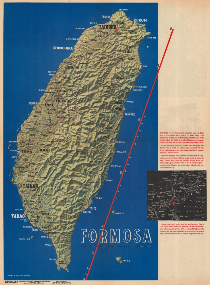
This is a 1945 Army Information Branch Newsmap map of Taiwan / Formosa. The focus of the map is the Potsdam Conference - which is highlighted on the verso. It was during this conference that Taiwan was 'officially' returned to China following World War II (1939 - 1945) - in an arguable rebuke of the 1941 Atlantic Charter, which guaranteed Taiwan's independence.
A Closer Look
Created by the Research and Analysis Branch of the Office of Strategic Services (OSS - the wartime forerunner of the CIA), the map details Taiwan and identifies cities and towns across the island by the Japanese names. Airfields, roads, and railroads throughout are illustrated, along with Taiwan's dramatic topography. An inset map in the lower right situates Taiwan in a regional context, with distances to Japan, the Philippines, Korea, and numerous locations in China, including Hong Kong. Red text informs on recent history, from the Japanese annexation after the Sino-Japanese War (1894 - 1895) to the end of World War II in 1945.Verso Content - The Potsdam Conference
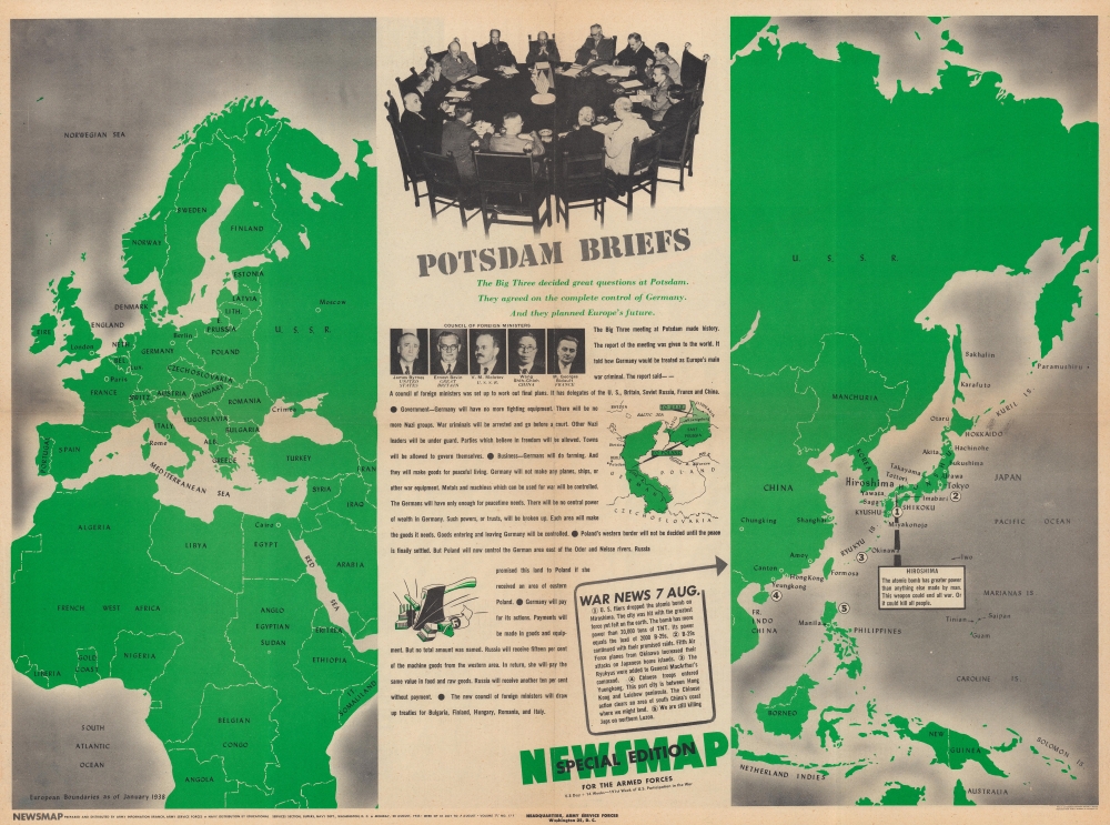
The verso summarizes the events of the Potsdam Conference and the conclusions reached by the Allies. A photograph of the negotiating table appears at top-center, and Truman, Churchill, and Stalin are identifiable. Portraits of the members of the recently created Council of Foreign Ministers appear as well. A map of the Eastern Hemisphere fills the sheet to the left and right of the central text, which lists all the achievements of the conference. In Japan, the number 1 marks Hiroshima, where the first atomic bomb was dropped by the U.S. The numbers 1 through 5 on the map correspond with a short text headed with 'War News 7 Aug.'Potsdam Conference
Held in Potsdam, Germany (in the Soviet zone of occupation) from July 17 - August 2, 1945, the conference brought together Soviet General Secretary Joseph Stalin, U.S. President Harry S. Truman, and British Prime Ministers Winston Churchill and Clement Atlee (Churchill lost the British general election during the conference). The Allies agreed that the four occupation zones into which Germany had been divided after its unconditional surrender would be maintained, that Germany's eastern border would be moved to the Oder-Neisse line, that a Soviet-supported group was the legitimate government of Poland, that Vietnam would be divided at the 16th Parallel, and as here, that Taiwan would be returned to China, along with other pressing issues.Publication History and Census
This map was created and published by the Army Information Branch in August 1945. We note eight examples cataloged in OCLC: Denison University, Ohio Wesleyan University, Davidson College, the University of Michigan, the Cincinnati and Hamilton County Public Library, South Illinois University at Edwardsville, the University of Missouri-Columbia, and the Denver Public Library.Source
NEWSMAP Series.
Newsmaps were published weekly between April 1942 and March 1946. Their content usually featured world maps, short summaries of the week’s military action, and photographs of troops and materiel. Early Newsmaps were printed on one side only, but, later in the war, they were printed on both sides, with the reverse bearing large-format maps, photographs, or other visual information. Several different versions of Newsmaps were produced: a large domestic version, a smaller overseas version, and an industrial version, which included more information about war production efforts. Two other editions appear in the United States Government Publications Monthly Catalogs, a 'Newsmap Special Edition' and a 'Newsmap Special Supplement for Special Training Units'.
Per the National Archives and Records Administration, ‘NEWSMAPS were not issued for general distribution. The posters were distributed to military installations, government and civilian groups working on War Department projects, and certain depository libraries, as designate by Congress, and one copy to Congressmen, if requested.’ The importance of the Newsmaps to the Army is related in the 1944 Basic Field Manual for The Special Service Company. The Manual states that as soon as the company reaches its destination ‘the company commander should contact the Special Service Branch in theater of operations headquarters, for copies of the weekly Newsmap.’ Also per the Manual
Per the National Archives and Records Administration, ‘NEWSMAPS were not issued for general distribution. The posters were distributed to military installations, government and civilian groups working on War Department projects, and certain depository libraries, as designate by Congress, and one copy to Congressmen, if requested.’ The importance of the Newsmaps to the Army is related in the 1944 Basic Field Manual for The Special Service Company. The Manual states that as soon as the company reaches its destination ‘the company commander should contact the Special Service Branch in theater of operations headquarters, for copies of the weekly Newsmap.’ Also per the Manual
The librarian should check the weekly Newsmap as soon as it is made available and should post it in a conspicuous place. He should take steps to see that the place where the Newsmap is posted is made known to all troops of the area in which the company or platoon is operating. This can be done effectively through notices in soldier newspapers, verbal announcements by those directly in charge of troops, and by posting announcements on bulletin boards.
Condition
Very good. Light wear along original fold lines. Text and map on verso.
References
OCLC 55673972.