This item has been sold, but you can get on the Waitlist to be notified if another example becomes available.
1877 Lloyd Set of Four Puzzle Maps of the United States and Europe
FourPuzzleMaps-lloyd-1877$750.00

Title
Improved Sectional Map: Railroad Map of the United States. / County of Westchester. / Europe. / County Map of New England.
1877 (dated) 12 x 17.5 in (30.48 x 44.45 cm)
1877 (dated) 12 x 17.5 in (30.48 x 44.45 cm)
Description
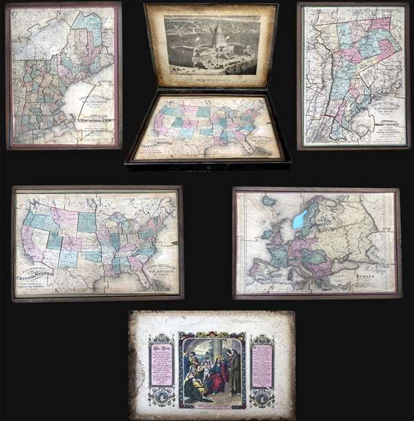
This is an 1877 set of four double-sided puzzle maps of the United States, Westchester, New England, and Europe contained in their original metal box. The verso of each puzzle also features an image, with a view of the United States Capitol Building on the verso of the United States puzzle and an illustration titled Christ Blessing Little Children on the verso of the remaining three puzzles. These illustrations also appear as pastedowns on the insides of the top and bottom portions of the metal box.
Railroad Map of the United States
The first puzzle depicts the continental United States from the Pacific Ocean to the Atlantic Ocean and from Canada to Mexico and the Bahamas. All the pieces are present, with each state (other than Rhode Island which is connected to Connecticut) separated into its own piece. Highly detailed, myriad cities and towns are labeled throughout the country, although the bulk of these are concentrated east of the Missouri River. As this is a railroad map of the United States, railroad lines are illustrated from coast to coast, although only a handful are labeled, including the Union Pacific and the Kansas Pacific. Certain lines, such as the Northern Pacific and the Southern Pacific, include dashed section, illustrating incomplete stretches of that line.
County Map of Westchester
The second puzzle depicts the county of Westchester, New York. The map depicts the region from the west bank of the Hudson River to Ridgefield and New Canaan and from Garrison's and Lake Mahopac to Harlem and Manhasset Bay. Highly detailed, each township is shaded a different color to allow for easy differentiation. Towns and villages are illustrated and labeled throughout, including Peekskill, Bedford, and Tarrytown. Several railroad lines are illustrated by thick black lines, such as the Hudson River Division of the New York Central and Hudson Railroad. The Croton Aqueduct, which supplied drinking water to New York City from 1842 until 1940, is illustrated from the Croton River in Westchester County along the Hudson River to New York City.
Europe
The third puzzle depicts the continent of Europe from the Atlantic Ocean to the Caspian Sea and from the Arctic Ocean to the Mediterranean Sea and North Africa. Perhaps the most intriguing aspect of this map is the borders of Germany, which reflect German gains during the Franco-Prussian War when they took the provinces of Alsace and Lorraine from France. Austria-Hungary, the Central European monarchy, occupies part of modern-day Italy, and the Balkans are a part of the Ottoman Empire. One piece of this puzzle (Norway) is missing.
County Map of New England
The fourth and final map of the set is a county map of New England depicting from Quebec and New Brunswick to Long Island and from New York to the Atlantic Ocean. Counties are labeled and shaded different colors to allow for easy differentiation. Meticulously detailed, innumerable cities, towns, and villages are labeled, including every stop on each illustrated railroad line. Both Nantucket and Martha's Vineyard are illustrated and labeled. The same level of detail is present in Quebec and New York State.
These maps were originally created by H. H. Lloyd and Company and the puzzles were manufactured by W. R. Price and Company of Mt. Kisco New York, whose imprint has been added to several o the maps. The four maps are accompanied by and stored in their original metal box, which includes the view of the United States Capitol Building on the lid and the painting titled Christ Blessing Little Children on the bottom. Each map is also contained in its own wooden tray for easy removal from the box
This set is rare and we have been able identify no other known examples. Given the size of the box it is conceivable that there is one map missing from the set, as one more would fit, but without another known examples, there is no way to know.
Cartographer
H.H. Lloyd & Company (fl. 1860 - 1890) were 19th century American map and atlas publishers based in New York City. They should not be confused with the competing New York firm with of a similar name, J. T. Lloyd, with whom H. H. Lloyd had a ongoing conflict. The firm was founded by H. H. Lloyd and Benjamin S. Demarest in 1860. The H. H. Lloyd firm published numerous atlases, wall maps, and gazetteers before, during and after the American Civil War. These include some of the best maps of the period, many of which were used as battle plans by various Civil War generals on both sides of the conflict. From various offices around the city, the H.H. Lloyd firm worked with other prominent firms of the period including H. S. Stebbins, Warner and Beers to produce numerous state and county atlases. Around 1880 Demarest took full control of the firm, possibly suggesting that Lloyd either died or retired. Though H. H. Lloyd and Company continued to produce maps well in to the 1880s, the firm lost much of its momentum and eventually, by 1890, closed its doors. H. H. Lloyd is sometimes confused with J. T. Lloyd, another map publisher of the period who produced a small number of United States and regional maps sympathetic to the Confederacy. Both H. H. Lloyd and B. Demarest were Union supporters, Demarest having served as a Major in the Union Army. More by this mapmaker...
Condition
Good. Set contains four separate puzzles: Railroad Map of the United States, County of Westchester, Europe, and County Map of New England. Europe map missing one piece, all others complete. Soiling to Map of Europe and County Map of New England. View of United States Capitol Building on verso of Railroad Map of the United States. Painting Christ Blessing Little Children framed by Lord's Prayer on verso of other three puzzles.