1917 Hanot Pictorial Wall Map of the World Fur Trade
FourruresWorld2-hanot-1917$7,500.00


Title
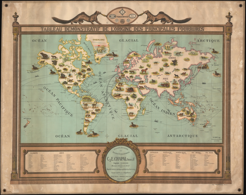
Tableau Demonstratif de L'Origine des Principales Fourrures.
1917 (dated) 36.5 x 49.5 in (92.71 x 125.73 cm) 1 : 47115000
1917 (dated) 36.5 x 49.5 in (92.71 x 125.73 cm) 1 : 47115000
Description
A remarkable and rare 1917 pictorial wall map of the world issued to promote the furrier business of C. et E. Chapal. This is one of the earliest modern pictorial maps we have seen, predating the rise of pictorial cartography in the mid-1920s and its golden age in the 1930s-1940s. The map combines informative graphics with playful imagery and persuasive promotional elements.
Survey of the Map
Laid down on a Mercator projection, the map covers the known world with various 'fur' animals illustrated pictorially according to region. Among the fur types covered are seals, rabbits, jaguars, lions, kangaroos, horses, beavers, mink, and many more. The map is surmounted by a shield supported by two mink. The shield bears logos for various Chapal sub-entities, including their offices in Montreuil, Brooklyn, Sens (Yonne), and Paris. Shipping lanes are noted.Pictorial Map Ahead of its Time
This map is a remarkable achievement in that it is about seven years ahead of its time. While earlier pictorial maps do exist, this particular style of pictorial map, defined by informative vignettes of infographic value, was uncommon before the rise of the art-deco movement in the mid-1920s. The style was probably inspired by French maps issued in the late 19th century by Andriveau-Goujon, Vuillemin, and others, which used pictorial vignettes on city and world maps to promote tourism and display ethnographic content. It is thus not surprising that Hanot's map appeared in France. The map is revolutionary in its use of a similar pictorial style within the thematic context of promoting the fur trade. As such, it is a transitional piece, more whimsical than the French pictorial maps of the late 19th century, but not as cartoonish as the Art Deco era pictorial maps that would begin appearing within the subsequent ten years.Publication History and Census
This map was printed by H. G. Hanot in 1917 for the firm of C. et E. Chapal. The map appears in at least two states, one corresponding to the present example, with more decorative lettering in the title, and a later edition with simplified lettering. We have been unsuccessful in tracing the maker, Hanot, but the publisher, Chapal, remains active in the leather and fur trade to this day. Examples of the map are rare, but it has appeared at French auctions 2 - 3 times in the last 20 years. We note a single cataloged example in OCLC, which is part of the collection at the University of Illinois at Urbana Champaign.Cartographer
C. et E. Chapal (1832 - 1932) are French furriers and tanners active from the early 19th century to present. The firm was founded in 1832 by Leonard Chapal (1828 - 1906) and Marien Cougny (1768 - 1841) as dyers of rabbit fur in Crocq, France. Achieving some success, they expanded their operation in 1857, opening an office in Montreuil-sous-Bois, just outside of Paris. The firm then taken over by two brothers, Clément Chapal (1857 - 1920) and Émile Chapal (1858 - 1932), who renamed it C. et E. Chapal. Their offices were located at 9, Rue Kleber, Montreuil-sous-Bois. In 1881, Émile Chapal relocated to Brooklyn, New York, to found a subsidiary company, Chapal Brothers and Company of Brooklyn. The firm, operating as Maison Chapal, remains active today and is a major fashion concern. More by this mapmaker...
Condition
Very good. Mounted on original linen. Light water staining in outer margins. Metal grommets at corners for hanging.
References
OCLC 1083641535.