
This item below is out of stock, but another example (left) is available. To view the available item, click "Details."
Details
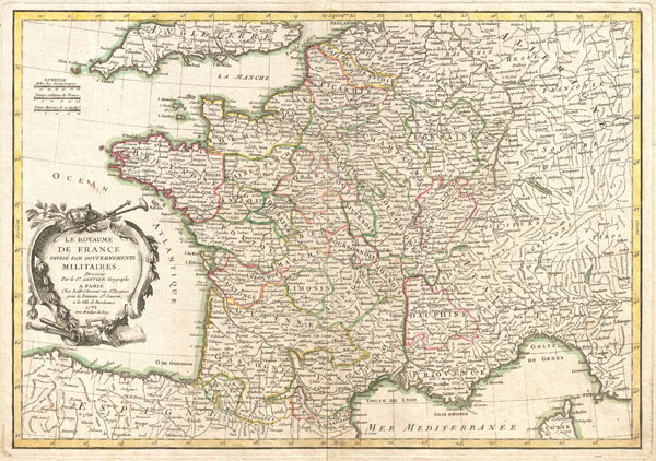
1762 Janvier Map of France
1762 (dated) $250.00
1762 Janvier Map of France
FranceMil-janvier-1762$112.50

Title
La Royaume de France Divise Par Gouvernements Militaires.
1762 (dated) 12.5 x 17.5 in (31.75 x 44.45 cm)
1762 (dated) 12.5 x 17.5 in (31.75 x 44.45 cm)
Description
A beautiful example of Jean Janvier's decorative map of France. Covers the entirety of France from England to Corsica and from Germany to Spain. Divided into military departments with color coding according to region. Offers excellent detail throughout showing mountains, rivers, forests, national boundaries, regional boundaries, forts, and cities. A large decorative title cartouche appears in the lower left quadrant. Drawn by Jean Janvier in 1762 for issue as plate no. 3 in Jean Lattre's 1776 edition of the Atlas Moderne.
CartographerS
Jean Denis Janvier (fl. 1746 - 1776), sometime also known as 'Robert', was a Paris based cartographer active in the mid to late 18th century. Janvier signed his maps Signor Janvier. By the late 18th century, Janvier was awarded the title of 'Geographe Avec Privilege du Roi' and this designation appears on many of his later maps. Janvier worked with many of the most prominent French, English and Italian map publishers of his day, including Longchamps, Faden, Lattre, Bonne, Santini, Zannoni, Delamarche, and Desnos. More by this mapmaker...
Jean Lattré (170x - 178x) was a Paris based bookseller, engraver, globe maker, calligrapher, and map publisher active in the mid to late 18th century. Lattré published a large corpus of maps, globes, and atlases in conjunction with a number of other important French cartographic figures, including Janvier, Zannoni, Bonne and Delamarche. He is also known to have worked with other European cartographers such as William Faden of London and the Italian cartographer Santini. Map piracy and copyright violations were common in 18th century France. Paris court records indicate that Lattré brought charges against several other period map publishers, including fellow Frenchman Desnos and the Italian map engraver Zannoni, both of whom he accused of copying his work. Lattré likes trained his wife Madame Lattré (né Vérard), as an engraver, as a late 18th century trade card promotes the world of 'Lattré et son Epouse.' Lattré's offices and bookshop were located at 20 rue St. Jaques, Paris, France. Later in life he relocated to Bordeaux. Learn More...
Source
Lattre, Jean, Atlas Moderne ou Collection de Cartes sur Toutes les Parties du Globe Terrestre, c. 1775.
Condition
Very good condition. Minor centerfold toning. Blank on verso. Platemark visible.
References
Phillips (Atlases) 664. National Maritime Museum, 215.