This item has been sold, but you can get on the Waitlist to be notified if another example becomes available, or purchase a digital scan.
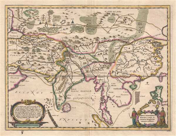
1667 Kircher Map of Asia
GeodoboricaAsia-kircher-1667$225.00

Title
Tabula Geodoborica Itinerum a Varijs in Cataium susceptorum rationem exhibens.
1667 (undated) 11 x 14.5 in (27.94 x 36.83 cm) 1 : 15000000
1667 (undated) 11 x 14.5 in (27.94 x 36.83 cm) 1 : 15000000
Description
This is a 1667 Athanasius Kircher map of Asia illustrating several routes from the Middle East to China. The map depicts the continent from the Caspian Sea, Persia, the Persian Gulf, and the Arabian Peninsula to the Pacific Ocean and from Siberia to the Indian Ocean. Originally published in Kircher's celebrated work Athanasii Kircheri e Soc. Jesu China monumentis, qua sacris qua profanis, nec non variis Naturae et artis spectaculis, aliarumque rerum memorabilium argumentis illustrata, auspiciis Leopoldi primi, Roman. Imper. Semper augusti Munificentissimi Mecaenatis, known as China Illustrata, Kircher's map is based on reports and testimony from Jesuit missionaries who had been to China, as Kircher himself had never made the voyage. At least four different overland transcontinental routes are presented, with waypoints, settlements, and towns labeled along each one. One sea route takes the traveler from the Strait of Hormuz, through the Arabian Sea, around India and through the strait separating India from Sri Lanka, then across the Bay of Bengal and through the Strait of Malacca and finally around the Indochinese peninsula to Macau. China, Tibet, Persia, Siam, Hainan, and 'Tartaria Magna' are among the labeled regions, and cities, such as Beijing, (Pequin), Malacca City, Johor Bahru (Iohor), and Macau (Macao) are also labeled. Swamps, forests, and mountain ranges allow the viewer to have some understanding of the terrain, along with the rivers that snake their way across the continent.
This map was created by Athanasius Kircher and published in his 1667 book China Illustrata. Following its publication, China Illustrata became one of the most popular and influential books of the 17th century. Though criticized by academics of the era for being 'too mainstream' and 'not scholarly enough', it has been argued that China Illustrata was the most important written source for shaping the Western understanding and knowledge of China for over two hundred years.
This map was created by Athanasius Kircher and published in his 1667 book China Illustrata. Following its publication, China Illustrata became one of the most popular and influential books of the 17th century. Though criticized by academics of the era for being 'too mainstream' and 'not scholarly enough', it has been argued that China Illustrata was the most important written source for shaping the Western understanding and knowledge of China for over two hundred years.
Cartographer
Athanasius Kircher (c. 1601 - 1680) was a 17th century German Jesuit scholar and one of the most respected and remarkable men of his time. A master of languages, mathematics, science, geography, physics and oriental studies, many consider Kircher to be 'the last true Renaissance man.' Kircher attained almost global fame in his lifetime for his numerous scholarly publications. Indeed, Kircher was the first documented scholar able to fully support himself on his own work, which, in his case, included some forty volumes on diverse fields. As a Catholic in Germany, Kircher was frequently at odds with the rising powers of Protestantism. Consequently, in 1628 he joined the priesthood and after extensive world travels eventually settled in Rome. There he was employed as a Professor of Mathematics and Oriental Languages at the Collegio Romano. Inspired by the eruption of Vesuvius in 1637 and the two weeks of earthquakes that shook Calabria in 1638, Kircher turned his considerable intellect to the natural world. Kircher's research into Geography and Oceanography culminated in the postulation that tides and currents were caused by water moving to and from a great subterranean ocean. Kircher published his geographic work in the important 1664 Mundus Subterraneus, which in addition to several world and oceanic charts, included a fascinating map of Atlantis. Kircher is nonetheless, not unimpeachable. One anecdote tells how a rival scholar presented Kircher with a manufactured gibberish manuscript he claimed to be an recently discovered ancient Egyptian text in need of translation. Kircher produced the translation instantly. In addition to his significance as a scholar, Kircher is best known for his invention of the Magic Lantern, precursor to modern cinema. He also founded the Museum Kircherianum in Rome. More by this mapmaker...
Source
Kircher, A. Athanasii Kircheri e Soc. Jesu China monumentis, qua sacris qua profanis, nec non variis Naturae et artis spectaculis, aliarumque rerum memorabilium argumentis illustrata, auspiciis Leopoldi primi, Roman. Imper. Semper augusti Munificentissimi Mecaenatis. (Amsterdam) 1667.
Condition
Very good. Verso repair to centerfold separation. Blank on verso.
References
OCLC 165595445.