1706 Meyer Broadsheet Celebrating the Study of Geography
Geographia-meyer-1706$2,800.00

Title
Geographia: Die Erd Beschreibung.
1706 (dated) 9 x 10 in (22.86 x 25.4 cm)
1706 (dated) 9 x 10 in (22.86 x 25.4 cm)
Description
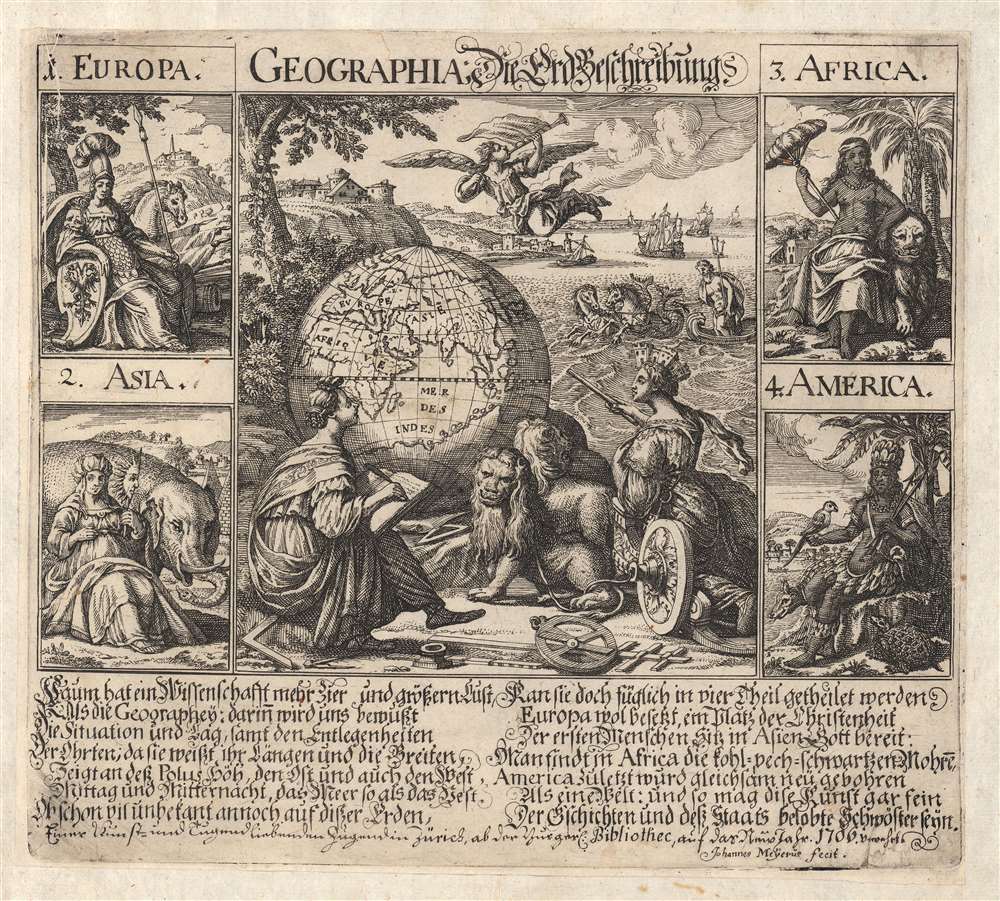
This is a rare 1706 Johannes Meyer broadside dedicated to the science of geography, showing allegorical representations of the continents and a globe. It includes a German text describing the purposes of geography as well as briefly describing the four parts of the world: Europe, Asia, Africa, and America.
The background may indicate what 'THAT bit' might reveal: cities on distant shores, ships plying an ocean (we know it's an ocean because Poseidon is also in it, with his sea-chariot and hippocampi. Above the whole scene, an angel on the wing trumpets away.
Happy New Year!
Beginning in 1645 and continuing until 1939, the council of the Burgerbibliothek Zürich (Zürich Public Library) celebrated the new year by printing a broadsheet for the children of the city. These New Year's papers, Neujahrsblättern, were attractively engraved works intended to promote study at the library, particularly of the sciences. They were first created by the poet and theologian Johann Wilhelm Simler (1605 - 1672) and Zürich engraver Conrad Meyer (1618 - 1689) and were the first instances of printed broadsheets combining text and images for educational purposes. After the deaths of Simler (1672) and Meyer (1689), Conrad's son Johannes took over this duty along with the rest of the business; Johannes appears to have developed his own work rather than simply reprinting his father's: we are aware of other examples of Johannes' Neujahrsblättern focusing on the sciences, namely his Physica (1697) and Mathematica (1699). These were separately issued works - not bound in a book - and were moreover intended for the use of children, and consequently, very few survive. This is a pity because the topicality of each annual Neujahrsblättern provides a unique view of the theological, political, social, and historical issues affecting Zürich at the time. The present example was printed to celebrate the New Year of 1706.Poetic Text, Allegorical Imagery
'What science is loftier than Geography?' opens the fourteen-line poem at the bottom of the sheet. It (extremely) briefly praises geography's ability to show the situation of the world, its poles and directions, and its power to reveal the remote parts of the world. It goes on to reduce, to one line apiece, the entire idea of Europe, Asia, Africa, and America. The engraved image is divided into five parts. Four of these represent the four parts of the world, using iconography made familiar in the cartographic decoration of the previous century: each continent is allegorically represented in the form of a woman.- Europa is an armed and armored regal figure: on her shield are the arms of the Holy Roman Empire; in the background is a city with a church steeple. She is surrounded by spears, banners, and cannons, the tools of conquest; she is accompanied by a horse.
- Asia is clad in silks and wears a turban evocative of the Turkish Sultans. She carries a mask of the sun's face, an allusion to her place in the east. Asia is accompanied by an elephant, which all but obscures the city in the distance, which, rather than a steeple, bears a tower with a crescent atop it - indicating a Muslim land. Also, the background includes the pyramids of Egypt (an interesting tell: European geographers tended to think of Egypt as belonging to Asia rather than to Africa.)
- Africa is portrayed naked to the waist, quite dark-skinned, with a feather parasol to keep off the sun and emphasize her exoticism. She is accompanied by a lion, and the background shows palm trees and low buildings amongst a forest.
- America is shown darker than Africa, clad in feathers, bearing spears, and with a parrot in her hand. A low, walled city can be seen against distant mountains. Her other animal companions are a tortoise and what appears to be an extremely large armadillo (oddly, the pairing of America with a massive armadillo as her animal mount is not unique here but occurs in a number of similar vignettes during the 17th century).
The background may indicate what 'THAT bit' might reveal: cities on distant shores, ships plying an ocean (we know it's an ocean because Poseidon is also in it, with his sea-chariot and hippocampi. Above the whole scene, an angel on the wing trumpets away.
Publication History and Census
This copperplate engraving was executed in late 1705 for its 1706 publication in Zürich; we are aware of only one edition, and it appears that the Neujahrsblättern were not reprinted or re-used. It was separately issued, and most examples would not have enjoyed the protection of a book. This example has, at some early date, been laid onto a larger sheet of laid paper- probably in order to bind it into a larger book, which has resulted in the remarkable survival of this extremely rare engraving. OCLC catalogs a single copy in the Zentralbibliothek Zürich. We have encountered no other copies on the market.Cartographer
Johannes Meyer the Younger (1655 – 1712) was a painter, engraver and publisher of Zürich, Switzerland. He was brought up in the trade by his father, Conrad Meyer (1618 - 1689) of the same city, who had been a student of Matthäus Merian. Conrad was successful and prolific, producing more than a thousand works, among them Conrad Gyger's 1657 map of Switzerland and his own 1681 Planisphaerium Coeleste . Both Johannes and his father had engraved many of the Neujahrsblättern - 'New Year's Papers - printed by the Burgerbibliothek Zürich as New Years' gifts to the children of Zürich. More by this mapmaker...
Condition
Very good. Pasted down to a larger sheet for binding, with no mends.
References
OCLC 845248552.