This item has been sold, but you can get on the Waitlist to be notified if another example becomes available, or purchase a digital scan.
1874 Tardieu Map of Israel, Palestine or the Holy Land and the Geography of the Bible
GeographieBible-tardieu-1874$75.00

Title
Geographie de la Bible.
1874 (undated) 15 x 18 in (38.1 x 45.72 cm) 1 : 20000000
1874 (undated) 15 x 18 in (38.1 x 45.72 cm) 1 : 20000000
Description
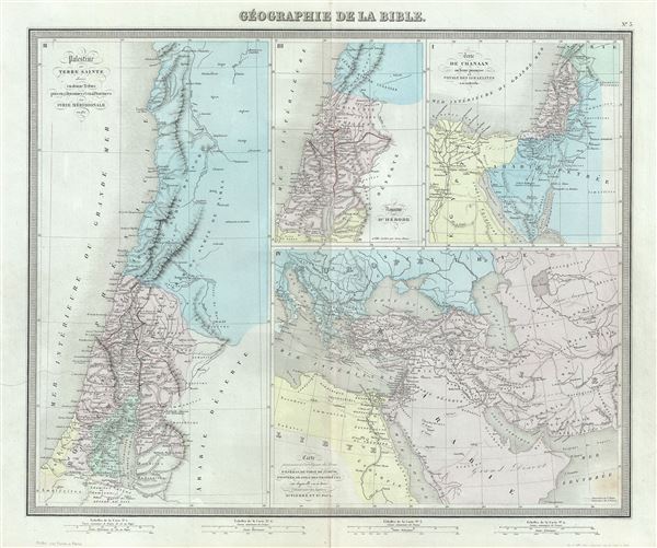
This is a scarce 1874 map of Israel, Palestine or the Holy Land with surrounding regions by Ambroise Tardieu. Essentially four maps on a single sheet, the maps depict the geography of the Bible. The first map, on the top right quadrant depicts the Promised Land of Canaan and the travels of the Israelites. It shows the course of the Israelites as they fled out of Egypt, across the Red Sea, and subsequently spent the next forty years wandering in the Sinai before migrating into the Promised Land by crossing the Jordan River just north of the Dead Sea.
The second map, on the left of the sheet depicts Palestine, Israel and The West Bank region. The third map in the top center is of the Herodian Kingdom and the villages visited by Jesus Christ. The map on the bottom right depicts the travels of the apostles St. Paul and St. Peter.
This map was prepared by Ambroise Tardieu and issued as plate 3 in his 1874 edition of Atlas Universel de Geographie Ancienne et Moderne.
CartographerS
Ambroise Tardieu (March 2, 1788 - January 17, 1841) was a prominent French cartographer and engraver operating in the late 18th and early 19th centuries. He was member of the large and prolific Tardieu family, which, for over 200 years, produced multiple skilled and active engravers. Tardieu's work is known for its beauty and accuracy as well as for its depth of detail. Tardieu's most important work is his version of John Arrowsmith's large format map of the United States, published in 1806. Ambroise Tardieu is eclipsed in fame by his son, artist and medical scholar, August Ambroise Tardieu. Ambroise Tardieu is also frequently confused with Jean Baptiste Pierre Tardieu, another unrelated French map and print engraver active in the early 19th century. More by this mapmaker...
Alexandre Aimé Vuillemin (1812 - 1880) was an engraver, publisher, and editor based in Paris, France in the middle of the 19th century. Despite a prolific publishing career, much of Vuillemin's life is shrouded in mystery. In 1852, he married Josephine Caroline Goret and they had at least one child, Ernestine Adèle Vuillemin, later in the same year. What is known is that his studied under the prominent French Auguste Henri Dufour (1798 - 1865). Vuillemin's most important work his detailed, highly decorative large format Atlas Illustre de Geographie Commerciale et Industrielle. Learn More...
Source
Furne, Jouvet et Cie Atlas Universel de Geographie Ancienne et Moderne (Paris), 1874.
Condition
Very good. Minor wear along original centerfold. Original platemark visible. Minor spotting.
References
Rumsey 4697.007 (1863 edition).