This item has been sold, but you can get on the Waitlist to be notified if another example becomes available.
1807 Klinger Geographicual Game: Cinq Parties du Monde
GeographyGame-klinger-1807$5,000.00

Title
Voyage dans les Cinq Parties du Monde. ou representations de 32 Nations avec VI cartes geographiques 1805.
1807 (dated) 18 x 15 in (45.72 x 38.1 cm)
1807 (dated) 18 x 15 in (45.72 x 38.1 cm)
Description
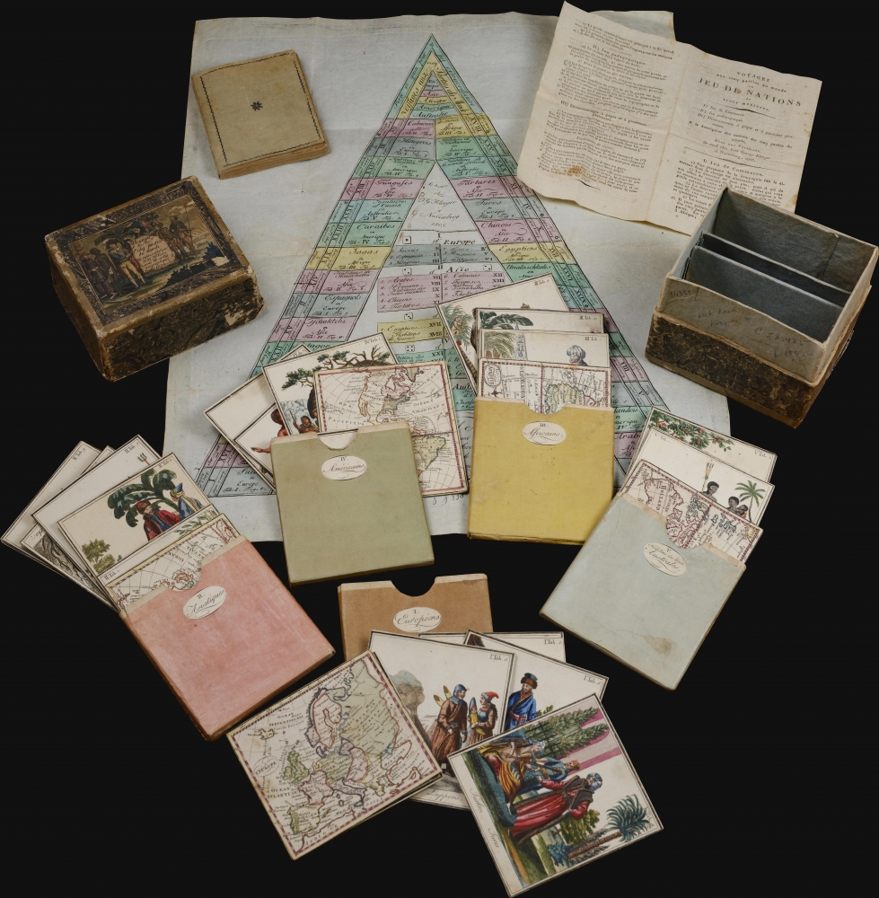
A stunning 1807 geographical game by Johann Georg Klinger and Johann Wolfgang Müller. It is among the most interesting and complex geographical games we have encountered. The beautifully produced game features 37 (35 present) cards, a game board, and instructions detailing how it can be played in three increasingly complex modes. The most advanced involved strategic planning of global commerce. As such, it could appeal to and delight children of all ages.
Despite being popular in its heyday, the game is now very rare. We note examples at the Universiteit van Amsterdam (1801), Princeton (two copies of the 1811), and the Staatsbibliothek zu Berlin (1813). Scarce on the market.
A Closer Look
The game is cleverly contained within its original box with engraved titling and marbled papers. There is an unusual pyramid shaped game board. There are five colored paper slipcases, each containing a finely engraved map and cards (captioned in both German and French) for the relevant region: Europe (6), Asia (8 of 10), Africa (4), America (8), and Australia (4). Each card is 3.5 x 4 inches. In addition, there is a printed 127-page volume describing the people and places illustrated. The box also contains a 4-page instruction manual. Some examples also have a double hemisphere world map, but this is not present here.Gameplay
Gameplay is involved and complex, with the game capable of being played in 3 different ways, depending on the sophistication of the players. In general players roll dice to and draw geographical cards to determine movements between countries and continents. At each location, players must recapitulate descriptions of inhabitants and/or geography based on the included miniature volume Description de differens Peuples remarquables des cinq parties du Monde. Geographical knowledge is adjudicated for quality, before additional money or tokens are traded to move forward.Publication History and Census
This game was a collaboration of geographer Johann Georg Klinger and gamemaker Johann Wolfgang Müller. The German first edition was introduced in 1801 as Reisen in die V Erdtheile. Beschreibung verschiedener merkwürdiger Völkerschaften in den fünf Welttheilen nebst Abbildung ihrer Nationaltrachten. The present example is the 2nd edition, 1807. We are aware of subsequent editions in 1811 and 1813. Most editions were issued from Nuremburg, but we also note examples bearing Turin and Paris imprints.Despite being popular in its heyday, the game is now very rare. We note examples at the Universiteit van Amsterdam (1801), Princeton (two copies of the 1811), and the Staatsbibliothek zu Berlin (1813). Scarce on the market.
CartographerS
Johann Georg Klinger (February 3, 1764 - February 2, 1806) was a German map, globe, and game maker active in Nuremburg during the early to mid-19th century. He was born in Nuremburg where his father was a coachman and fisherman. Klinger founded his firm around 1790, when his first globes began to appear. He was considered the most prominent globe maker of his generation. He worked closely with the engraver Johann Bernhard Bauer (1752 - 1839). After Klinger's untimely death, the firm was continued by his widow as 'J. Klinger’s Kunsthandlung'. In 1831, the firm and remaining stock was acquired by Johann Paul Dreykorn (1805 - 1875), who kept the same name. Carl Casimir Abel (1804 - 18??) bought it in 1852, after which the name was changed to 'Abel-Klinger Kunsthandlung'. The firm remained active until the early 20th century. More by this mapmaker...
Johann Wolfgang Müller (July 20, 1765 - September 23, 1828) was a Nuremburg-based educator and publisher of playing cards and other games. Müller was born in Nuremburg, Germany. He studied from 1773 - 1783 at the Spitalschule in Nuremburg before transferring to Altdorf, where he completed his studies in 1788. In 1796, he began teaching mathematics and French at Nuremburg's Egidiengymnasium. He began publishing educational games, books, and globes in 1791/2, in addition to a large corpus of mathematical treatises. He retired in 1801 due to an unknown mental illness and died in 1828 of edema (dropsy). Learn More...
Condition
Very good. Original box exhibits some wear, but stable. Else clean.
References
OCLC 930338438 (Staatsbibliothek zu Berlin). Stauss, Thomas, Frühe Spielwelten: Zur Belehrung und Unterhaltung. Die Spielwarenkataloge von Peter Friedrich Catel (1747-1791) und Georg Hieronimus Bestelmeier (1764-1829), pp. 360-65. Buijnsters, P.J. and Buijnsters-Smets, Leontine, Papertoys. Speelprenten en papieren speelgoed in Nederland (1640-1920), pp. 137-8, illus. p. 176.