1966 Bureau of Economic Geology Geologic Map of Big Bend National Park, Texas
GeologicBigBendNP-economicgeology-1966$500.00

Title
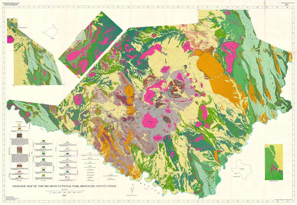
Geologic Map of Big Bend National Park, Brewster County, Texas.
1966 (dated) 39.75 x 57.5 in (100.965 x 146.05 cm) 1 : 62500
1966 (dated) 39.75 x 57.5 in (100.965 x 146.05 cm) 1 : 62500
Description
This is a 1966 Bureau of Economic Geology map of Big Bend National Park, Texas. Thirty-two colors highlight geologic formations throughout the park. Mountain ranges, peaks, canyons, mesas, hills, flats, and other locations are labeled. An inset in the upper left extends the central map to include the northeast portion of the park, which includes part of the Sierra de Carmen and the Santiago Mountains. A map key situated near this inset situates it with regard to the rest of the map. A second inset in the upper left focuses on the Christmas Mountains. A third inset in the lower right details the Mariscal Mine. A small map situating Big Bend National Park within Texas appears just to the left of the Mariscal Mine inset.
Big Bend National Park
Big Bend National Park opened to visitors on July 1, 1944, and is the largest protected area of Chihuahuan Desert ecology and topography in the United States. Originally established as Texas Canyons State Park in 1933, the United States Congress began the process of acquiring the land from Texas in 1935. Texas deeded the land to the federal government on June 12, 1944. Big Bend National Park is the only national park in the United States to contain an entire mountain range: the Chisos Mountains. The Park also contains habitats for hundreds of animal and plant species, as well as 10,000-year-old archaeological sites, dinosaur fossils, and 118 miles of the U.S.-Mexico border along the Rio Grande.Publication History and Census
This map was created from the geological studies of by Ross A. Maxwell and John T. Lonsdale. It was published in 1968 by the Bureau of Economic Geology at the University of Texas at Austin for Ross A. Maxwell's The Big Bend of the Rio Grande: A Guide to the Rocks, Geologic History, and Settlers of the Area of Big Bend National Park. This map and the guide in which it was published are well represented in institutional collections.Source
Maxwell, R.A., The Big Bend of the Rio Grande: A Guide to the Rocks, Geologic History, and Settlers of the Area of Big Bend National Park, (Austin: University of Texas) 1968.
Condition
Very good. Wear and some toning along original fold lines. Verso repairs at fold intersections. Exhibits slight loss at some fold intersections.
References
OCLC 20137769.