1843 Malte-Brun Map of Germany
Germany-maltebrun-1843$100.00

Title
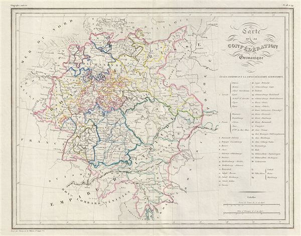
Carte de la Confederation Germanique.
1843 (undated) 13.5 x 17 in (34.29 x 43.18 cm)
1843 (undated) 13.5 x 17 in (34.29 x 43.18 cm)
Description
This is a fine example of Conrad Malte-Brun's 1843 map of the Germanic Confederation. The map covers Germany from Holstein to the Adriatic Sea. A table along the right margin lists the states comprising the Germanic Confederation. The modern day countries of Poland, Czech Republic and Austria are included.
After the defeat of Napoleon, the Congress of Vienna created The German Confederation to coordinate the economies of these separate but culturally related German-speaking countries. The Confederation acted as a buffer zone between Austria and Prussia, the two largest and most powerful member states. Nonetheless the rivalry between the two powerful states increased until it finally broke out into the Austro-Prussian War. Prussia won the Austro-Prussian War in 1866 which ultimately led to the collapse of the German Confederation. A few years later, in 1871, most of the former Confederation states were folded into the newly proclaimed German empire.
Boundaries are color coded according to states and districts. Various cities, towns, rivers, lakes and other topographical details are marked, with relief shown by hachure. This map was issued as plate nos. 48 and 49 in Conrad Malte-Brun's 1843 Precis de la Geographie Universelle.
Cartographer
Conrad Malte-Brun (August 12, 1755 - December 14, 1826) was an important late 18th and early 19th century Danish / French cartographer and revolutionary. Conrad was born in Thisted, Denmark. His parents encouraged him to a career in the Church, but he instead enrolled in the University of Copenhagen. In the liberal hall of academia Conrad became an ardent supporter of of the French Revolution and the ideals of a free press. Despite the harsh censorship laws of crown prince Frederick VI, Malte-Brun published numerous pamphlets criticizing the Danish government. He was finally charged with defying censorship laws in 1799 and forced to flee to Sweden and ultimately France. Along with colleague Edme Mentelle, Malte-Brun published his first cartographic work, the Géographie mathématique, physique et politique de toutes les parties du monde (6 vols., published between 1803 and 1807). Conrad went on to found Les Annales des Voyages (in 1807) and Les Annales des Voyages, de la Géographie et de l'Histoire (in 1819). He also founded the Paris Société de Géographie . In time, Conrad Malte-Brun became known as one of the finest French cartographers of his time. His son Victor Adolphe Malte-Brun (1816 - July 13, 1889) followed in his footsteps, republishing many of Conrad's original 18th century maps as well as producing numerous maps of his own. The Malte-Brun firm operated well into the 1880s. More by this mapmaker...
Source
Malte-Brun, Precis de la Geographie Universelle, ou Description de Toutes les Parties du Monde sur un Plan Nouveau, d'après les Grandes Divisions Naturelles du Globe, (Paris) 1843.
Condition
Very good. Original centerfold visible. Blank on verso.