1835 Malte-Brun Map of Central Germany
GermanyCentral-maltebrun-1837$100.00

Title
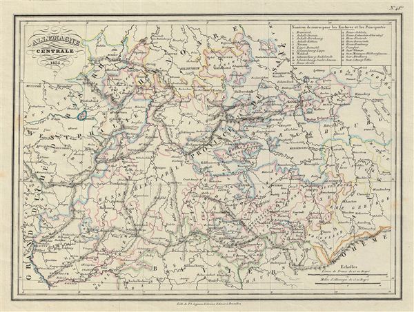
Allemagne Centrale.
1837 (undated) 10 x 13 in (25.4 x 33.02 cm)
1837 (undated) 10 x 13 in (25.4 x 33.02 cm)
Description
This is a fine example of the 1835 Malte-Brun map of Central Germany. Centered on Saxony, the map Covers from Rhineland and Westphalia to Bohemia and Brandenberg. A table in the upper right quadrant lists the numbers referring to the enclaves and principalities. In 1180 Duke Henry the Lion fell, and the medieval Duchy of Saxony dissolved. The Saxe-Wittenberg lands were passed among dynasties who took the tribal name Sachsen (Saxons) upstream as they conquered the lands of the Polabian Slavs further up the elbe. The Polabian Slavs had migrated to this area of Germany in the second half of the first millennium A.D., and had been largely assimilated by the Holy Roman empire by the time this map was made. Today, the German government recognizes some 60,000 'Sorbs,' or descendants of the Polabian Slavs, who have retained their language and culture.
Boundaries are color coded according to the imperial circles. The 'circles' of Germany are the 'imperial circles,' administrative units created for tax and defense purposes by the Holy Roman empire, of which these areas were a part. Various cities, towns, rivers, lakes and other topographical details are marked, with relief shown by hachures. This map was issued as plate no. 43 bis. in Malte-Brun's Atlas de Geographie Universelle
Boundaries are color coded according to the imperial circles. The 'circles' of Germany are the 'imperial circles,' administrative units created for tax and defense purposes by the Holy Roman empire, of which these areas were a part. Various cities, towns, rivers, lakes and other topographical details are marked, with relief shown by hachures. This map was issued as plate no. 43 bis. in Malte-Brun's Atlas de Geographie Universelle
Cartographer
Conrad Malte-Brun (August 12, 1755 - December 14, 1826) was an important late 18th and early 19th century Danish / French cartographer and revolutionary. Conrad was born in Thisted, Denmark. His parents encouraged him to a career in the Church, but he instead enrolled in the University of Copenhagen. In the liberal hall of academia Conrad became an ardent supporter of of the French Revolution and the ideals of a free press. Despite the harsh censorship laws of crown prince Frederick VI, Malte-Brun published numerous pamphlets criticizing the Danish government. He was finally charged with defying censorship laws in 1799 and forced to flee to Sweden and ultimately France. Along with colleague Edme Mentelle, Malte-Brun published his first cartographic work, the Géographie mathématique, physique et politique de toutes les parties du monde (6 vols., published between 1803 and 1807). Conrad went on to found Les Annales des Voyages (in 1807) and Les Annales des Voyages, de la Géographie et de l'Histoire (in 1819). He also founded the Paris Société de Géographie . In time, Conrad Malte-Brun became known as one of the finest French cartographers of his time. His son Victor Adolphe Malte-Brun (1816 - July 13, 1889) followed in his footsteps, republishing many of Conrad's original 18th century maps as well as producing numerous maps of his own. The Malte-Brun firm operated well into the 1880s. More by this mapmaker...
Source
Malte-Brun, Atlas Complet du Precis de la Geographie Universelle, (Paris) 1837.
Condition
Very good. Blank on verso.
References
Rumsey 0458.041. Phillips (Atlases) P6079.