This item has been sold, but you can get on the Waitlist to be notified if another example becomes available, or purchase a digital scan.
1891 Rand McNally Map of Eastern Germany and Prussia
GermanyEast-randmcnally-1895$37.50

Title
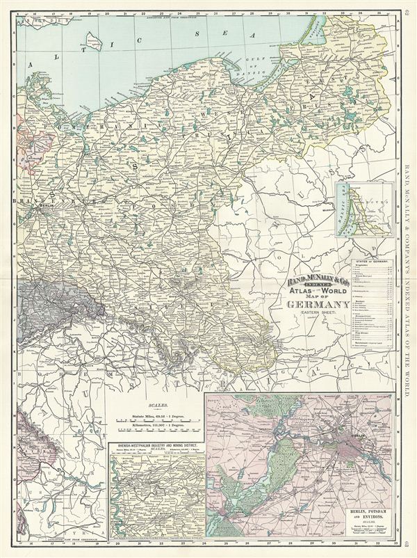
Map of Germany (Eastern Sheet).
1891 (dated) 27 x 20 in (68.58 x 50.8 cm) 1 : 1400000
1891 (dated) 27 x 20 in (68.58 x 50.8 cm) 1 : 1400000
Description
This is a beautiful example of Rand McNally and Company's 1891 map of eastern Germany. It covers the eastern portion of the then German empire, mainly focusing on the Kingdom of Prussia. It includes the modern day nations of Poland, the Czech Republic and Germany. Two insets in the lower right quadrant detail Berlin and Potsdam and the Rhenish-Westphalian Industry and Mining District. A list of the States of Germany is included along the right border while the northern most part of Prussia is featured in another inset near the right border. Prussia attained its greatest importance in the 18th and 19th centuries when it dominated northern Germany politically, economically, and in population. This map was created a year after the dismissal of Chancellor Otto von Bismarck, the 'Iron Chancellor' who during the 19th century, pursued a policy of uniting the German principalities into a 'Lesser Germany' which would exclude the Austrian empire. Color coded according to territories, the map notes several towns, cities, rivers and various other topographical details with relief shown by hachure. This map was issued as plate nos. 62 and 63 in the 1895 issue of Rand McNally and Company's Indexed Atlas of the World - possibly the finest atlas Rand McNally ever issued.
Cartographer
Rand, McNally and Co. (fl. 1856 - present) is an American publisher of maps, atlases and globes. The company was founded in 1856 when William H. Rand, a native of Quincy, Massachusetts, opened a print shop in Chicago. Rand hired the recent Irish immigrant Andrew McNally to assist in the shop giving him a wage of 9 USD per week. The duo landed several important contracts, including the Tribune's (later renamed the Chicago Tribune) printing operation. In 1872, Rand McNally produced its first map, a railroad guide, using a new cost effective printing technique known as wax process engraving. As Chicago developed as a railway hub, the Rand firm, now incorporated as Rand McNally, began producing a wide array of railroad maps and guides. Over time, the firm expanded into atlases, globes, educational material, and general literature. By embracing the wax engraving process, Rand McNally was able to dominate the map and atlas market, pushing more traditional American lithographic publishers like Colton, Johnson, and Mitchell out of business. Eventually Rand McNally opened an annex office in New York City headed by Caleb S. Hammond, whose name is today synonymous with maps and atlases, and who later started his own map company, C. S. Hammond & Co. Both firms remain in business. More by this mapmaker...
Source
Rand McNally & Co., Foreign Countries. Rand, McNally & Co's Indexed Atlas of the World (Complete in Two Volumes)…, (Chicago) 1895.
Condition
Very good. Minor wear along original centerfold. Text on verso. Minor verso repair, bottom margin.
References
Rumsey 3565.016 (1897 edition). Philip (atlases) 1026 (1898 edition).