This item has been sold, but you can get on the Waitlist to be notified if another example becomes available, or purchase a digital scan.
1946 Topographic Map of Glacier Park, British Columbia, Canada
GlacierPark-deptmines-1946$75.00

Title
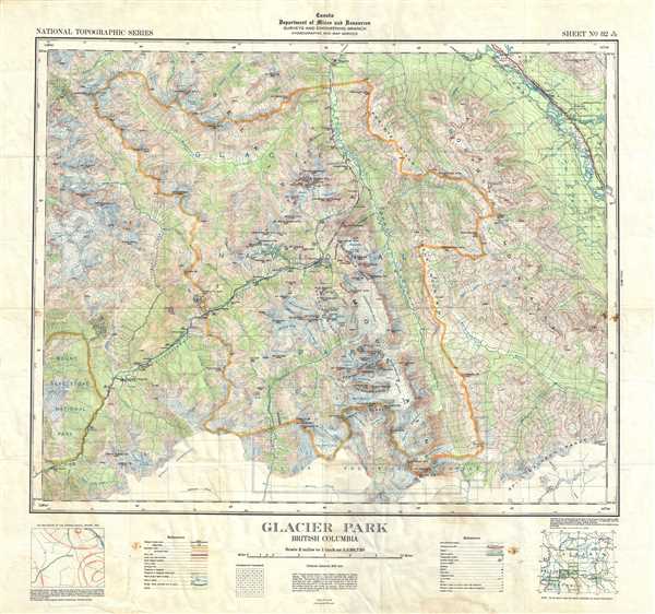
Glacier Park British Columbia.
1946 (dated) 24 x 24 in (60.96 x 60.96 cm) 1 : 126720
1946 (dated) 24 x 24 in (60.96 x 60.96 cm) 1 : 126720
Description
This is a nice example of the 1946 topographical survey chart or map of the beautiful Glacier National Park in British Columbia, Canada. The map covers the entire park and its vicinity, famous for large active glaciers and Canada’s largest cave systems, and extends from Mount Revelstoke National Park east to Spillimacheen Range. Throughout, the map marks railroad lines, roads, trails, marshes, rapids, bridges, forests, glaciers, cliffs, streams, and other topographical features. Cabins, buildings, offices and mines are also noted. Two inset maps are included along the bottom margins.
The map was originally compiled, drawn and printed at the office of the Surveyor General, Ottawa based on the surveys of the Topographical Survey of Canada in 1934 and reissued with corrections in 1946. Issued as chart no. 82N/SW of the National Topographic Series by the Department of Mines and Resources, Surveys and Engineering Branch.
The map was originally compiled, drawn and printed at the office of the Surveyor General, Ottawa based on the surveys of the Topographical Survey of Canada in 1934 and reissued with corrections in 1946. Issued as chart no. 82N/SW of the National Topographic Series by the Department of Mines and Resources, Surveys and Engineering Branch.
Condition
Very good. Minor wear and creasing along original fold lines. Foxing at several places.
References
OCLC: 28858250.