
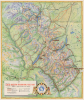
1939 Great Northern Railway Pictorial Map of Glacier National Park

This item has been sold.
Map of Glacier - Waterton International Peace Park.
The only true US-Canada cross-border National Park.
Choose a Collection:
- Digital Map Information
- Suitable for large format printing
- Full resolution TIFF file
- ICC color profile embedded
- Delivered instantly via download link
This Item
Enquire
The only true US-Canada cross-border National Park.
This is a 1939 Great Northern Railway pictorial map of Waterton-Glacier International Peace Park. Glacier, as it is commonly known, is the only true cross-border National Park, shared and managed between Canada and the United States. Within the park, the international border is, for all intents and purposes, nonexistent.A Closer Look
Coverage embraces the conjoined Waterton Lakes National Park in Alberta, Canada, and Glacier National Park in Montana, United States, stretching from Cardston, Alberta, south to Nimrod, Montana. Yellow lines bordered in black highlight paved roads, while red lines trace the park's trail network. Icons mark towns, lookout stations, ranger stations, and shelter cabins; and pictorial vignettes emphasize the chalets, hotels, and camps scattered throughout. Lakes shaded a brilliant blue stand out against the map's green landscape. Illustrations of some of the park's wildlife, including bighorn sheep, grizzly bears, mountain goats, and moose, add charm.The Waterton-Glacier International Peace Park
The Waterton-Glacier International Peace Park was established in 1932 after the U.S. Senate and the Canadian Parliament both passed bills. The idea originated with Canadian George 'Kootenay' Brown and American Albert Henry 'Death-on-the-trail' Reynolds. Brown was the first forest ranger-in-charge of Waterton, and Reynolds was a forest ranger in Montana, but was not hired by Glacier National Park until 1912. Reynolds is said to have earned his curious moniker because of his fast hiking pace. The nickname became especially poignant in 1913, when he snowshoed 17 miles in the bitter cold of winter to visit Brown. Reynolds arrived at Brown's cabin half-frozen and died the next day at the age of 65.Publication History and Census
This map was created and published by the Great Northern Railway in 1939. Twelve examples are cataloged in OCLC, but the map remains scarce on the private market.Condition
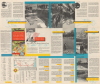
Very good. Light wear along original fold lines. Text and printed images on verso.
References
OCLC 38244815.