1740 Bellin Map or Plan of the Bay of Bengal
GolphedeBengal-bellin-1740$200.00

Title
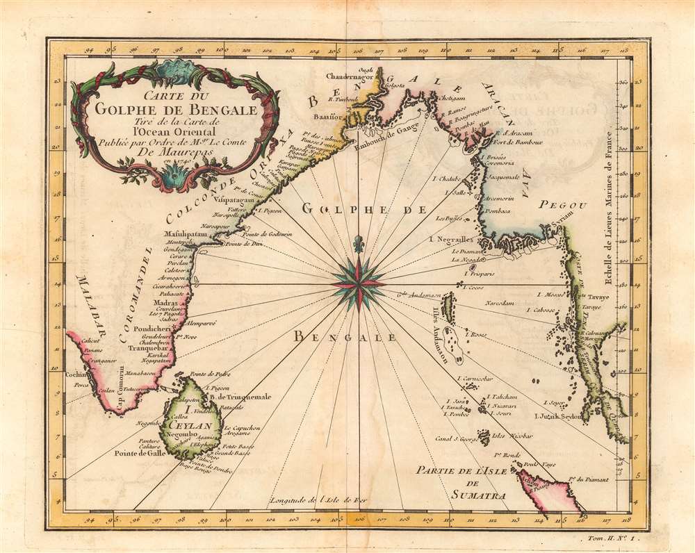
Carte du Golphe de Bengale.
1740 (dated) 8 x 10.25 in (20.32 x 26.035 cm) 1 : 8800000
1740 (dated) 8 x 10.25 in (20.32 x 26.035 cm) 1 : 8800000
Description
This is Jacques-Nicolas Bellin's lovely 1740 map of the Bay of Bengal. It illustrates the region at the height of French influence in India, when they nearly surpassed the British as the dominant European power on the subcontinent.
It is often forgotten that France had a presence in India. When this map was issued French influence was reaching its peak, with two areas of control near Pondicherry and Yanam (curiously absent here, but very close to Narsapur), and a far larger sphere of influence affected by alliances with local princely states. Like the British, the French were initially interested in establishing coastal trading outposts. But, in part as a result of an increasingly global competition between the British and French, territorial control of large portions of India became the driving goal of both powers.
In 1742, the new French governor of India, Joseph François Dupleix, supported a more aggressive approach vis-à-vis than his superiors in Paris. As a result, British and French tensions increased and overlapped with the War of the Austrian Succession, resulting in open conflict, with armies in India composed mostly of local allies. Conflict resumed after a brief peace with the Seven Years War, in which the British decisively gained the upper hand in India at the Battle of Plassey (1757). Still, the French retained their coastal strongholds of Pondicherry, Yanam, Mahe, and Karikal until after India attained independence from Britain in 1947, and they were not formally handed over to Indian sovereignty until 1962.
A Closer Look
Coastal cities around the Bay of Bengal are noted, along with islands in the bay (Andaman and Nicobar Islands, Ceylon). The capital of French India at Pondicherry (Pondicheri) is indicated with a star. Small islands in the eastern part of the bay (e.g. Preparis, Coco Islands) are depicted as larger than their actual size, likely because of their importance for European navigators trying to reach the Straits of Malacca.It is often forgotten that France had a presence in India. When this map was issued French influence was reaching its peak, with two areas of control near Pondicherry and Yanam (curiously absent here, but very close to Narsapur), and a far larger sphere of influence affected by alliances with local princely states. Like the British, the French were initially interested in establishing coastal trading outposts. But, in part as a result of an increasingly global competition between the British and French, territorial control of large portions of India became the driving goal of both powers.
In 1742, the new French governor of India, Joseph François Dupleix, supported a more aggressive approach vis-à-vis than his superiors in Paris. As a result, British and French tensions increased and overlapped with the War of the Austrian Succession, resulting in open conflict, with armies in India composed mostly of local allies. Conflict resumed after a brief peace with the Seven Years War, in which the British decisively gained the upper hand in India at the Battle of Plassey (1757). Still, the French retained their coastal strongholds of Pondicherry, Yanam, Mahe, and Karikal until after India attained independence from Britain in 1947, and they were not formally handed over to Indian sovereignty until 1962.
Publication History and Census
This map was drawn by Jacques-Nicolas Bellin and published as plate No. 1 in Vol. 2 of the 1740 edition of the Abbe Provost's L'Histoire Generale des Voyages. Either by itself or as part of Provost's book, it is cataloged as being held by a handful of libraries in Europe and North America.Cartographer
Jacques-Nicolas Bellin (1703 - March 21, 1772) was one of the most important cartographers of the 18th century. With a career spanning some 50 years, Bellin is best understood as geographe de cabinet and transitional mapmaker spanning the gap between 18th and early-19th century cartographic styles. His long career as Hydrographer and Ingénieur Hydrographe at the French Dépôt des cartes et plans de la Marine resulted in hundreds of high quality nautical charts of practically everywhere in the world. A true child of the Enlightenment Era, Bellin's work focuses on function and accuracy tending in the process to be less decorative than the earlier 17th and 18th century cartographic work. Unlike many of his contemporaries, Bellin was always careful to cite his references and his scholarly corpus consists of over 1400 articles on geography prepared for Diderot's Encyclopedie. Bellin, despite his extraordinary success, may not have enjoyed his work, which is described as "long, unpleasant, and hard." In addition to numerous maps and charts published during his lifetime, many of Bellin's maps were updated (or not) and published posthumously. He was succeeded as Ingénieur Hydrographe by his student, also a prolific and influential cartographer, Rigobert Bonne. More by this mapmaker...
Condition
Very good. Some dampstaining around central fold line.