1935 Inland American Printing View of Spokane Region, Grand Coulee Dam
GrandCouleeDam-inlandamerican-1935$250.00

Title
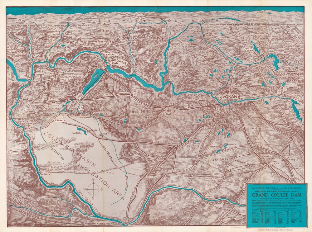
Panoramic perspective of the Spokane Region including the geological and scenic wonderland embracing the Grand Coulee Dam as it will appear when the development is completed.
1935 (undated) 17.75 x 23.75 in (45.085 x 60.325 cm)
1935 (undated) 17.75 x 23.75 in (45.085 x 60.325 cm)
Description
An impressive c. 1935 view of the Spokane region and eastern Washington produced by Inland American Printing for the Spokane Chamber of Commerce. The view is meant to highlight the Grand Coulee Dam, an ambitious project then under construction.
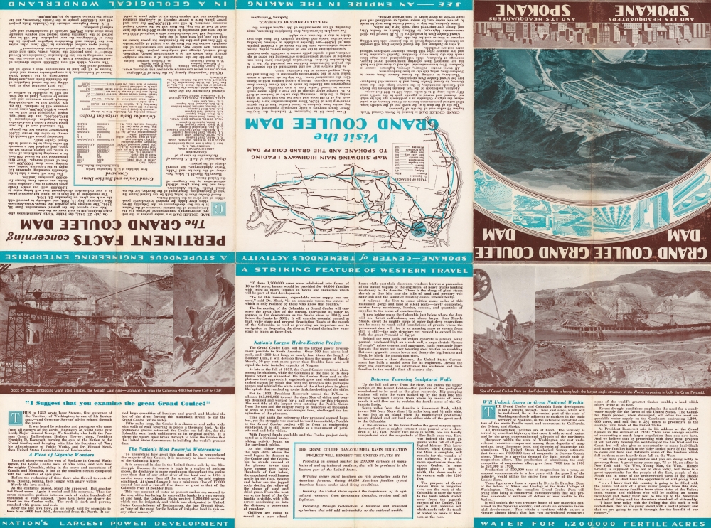
The verso includes a map of the western U.S. indicating highways leading to the dam along with photographs of the project site and text explaining the area's geological history, the aims of the dam project, the history of its construction to that point, and related information.
Although support for a concrete dam increased over the following decade, President Calvin Coolidge's Administration showed little interest in or support for the project. Studies were carried out by the U.S. Army Corps of Engineers, providing a solid basis for construction when political support did finally arrive with the start of the Franklin D. Roosevelt Administration in 1933. With a focus on power generation in addition to irrigation, funds were allocated and construction on the project began in July 1933. Designs were changed after construction began, from a 'low dam' to a more ambitious 'high dam' (the hydroelectric power generated by the 'high' dam was used to pump water into the basin), which delayed its completion until 1942. Nevertheless, the scale of the project and the benefits it provided made it a showcase piece for the Bureau of Reclamation and the Roosevelt Administration. It was later expanded with additional generators and has long been considered the largest power generation facility in the country by capacity.
Like nearly all the Bureau of Reclamation's dam projects, the Grand Coulee Dam received its share of controversy. It was especially damaging to local Native American communities, whose traditional methods of fishing and hunting were made untenable. Seasonal and permanent settlements, including burial grounds, of local native peoples were also submerged. Since the 1990s, the federal government has allocated funds for compensating the Coleville and Spokane tribes.
A Closer Look
Oriented towards the north, this view takes in eastern Washington including Spokane, the Grand Coulee Dam, and the Columbia Basin Irrigation Area, which was irrigated as a result of the dam's construction. A reservoir is displayed that would result from the construction of the 'high' dam, an extension of the project's original scope. A temporary 'U.S. engineers town' that sprang up next to the dam is noted. Aside from cities and towns, agricultural areas, highways, railways, national parks and forests, and Indian reservations are also illustrated.The verso includes a map of the western U.S. indicating highways leading to the dam along with photographs of the project site and text explaining the area's geological history, the aims of the dam project, the history of its construction to that point, and related information.
Grand Coulee Dam
The Grand Coulee Dam was first imagined in the late 19th century as a means of providing reliable irrigation for central and eastern Washington. The Grand Coulee is an ancient riverbed carved out by a glacier, making it a natural channel for snowmelt and rainwater, or for storing irrigation water. The concept of building a dam at the Grand Coulee was given impetus when the U.S. Bureau of Reclamation was created in 1902, with a focus on dam projects in the Western U.S. Still, the Grand Coulee project faced obstacles, including voters' rejection of a bond measure for it in 1914.Although support for a concrete dam increased over the following decade, President Calvin Coolidge's Administration showed little interest in or support for the project. Studies were carried out by the U.S. Army Corps of Engineers, providing a solid basis for construction when political support did finally arrive with the start of the Franklin D. Roosevelt Administration in 1933. With a focus on power generation in addition to irrigation, funds were allocated and construction on the project began in July 1933. Designs were changed after construction began, from a 'low dam' to a more ambitious 'high dam' (the hydroelectric power generated by the 'high' dam was used to pump water into the basin), which delayed its completion until 1942. Nevertheless, the scale of the project and the benefits it provided made it a showcase piece for the Bureau of Reclamation and the Roosevelt Administration. It was later expanded with additional generators and has long been considered the largest power generation facility in the country by capacity.
Like nearly all the Bureau of Reclamation's dam projects, the Grand Coulee Dam received its share of controversy. It was especially damaging to local Native American communities, whose traditional methods of fishing and hunting were made untenable. Seasonal and permanent settlements, including burial grounds, of local native peoples were also submerged. Since the 1990s, the federal government has allocated funds for compensating the Coleville and Spokane tribes.
Publication History and Census
This view was printed by the Inland American Printing Co. for the Spokane Chamber of Commerce. It is undated, but from context and the text on the verso can be dated to a period after 1934 but before the dam was completed. Due to uncertainty over the date and the existence of later editions printed after the dam was completed, the view is listed multiple times in the OCLC, often with an uncertain or approximated date. The present edition is held by as few as two and as many as twelve institutions.Cartographer
Inland American Printing Co. (c. 1915 - 1940) was a lithographic printer based in Spokane, Washington. The small number of cataloged works printed by them suggest a close association with both the city government and the Chamber of Commerce in Spokane. More by this mapmaker...
Condition
Very good. Slight wear on old fold lines.
References
OCLC 288719396, 967399343.