This item has been sold, but you can get on the Waitlist to be notified if another example becomes available, or purchase a digital scan.
1764 Bellin Map of the Great Lakes (first map to use the term 'Great Lakes')
GrandLacsduCanada-bellin-1764$675.00

Title
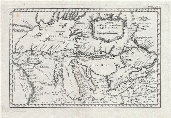
Carte des Cinq Grands Lacs du Canada.
1764 (undated) 9 x 13.5 in (22.86 x 34.29 cm) 1 : 5000000
1764 (undated) 9 x 13.5 in (22.86 x 34.29 cm) 1 : 5000000
Description
An unusual 1764 variant edition Jacques-Nicholas Bellin influential map of the Great Lakes. This is the earliest known map to use the term 'Great Lakes'. Cartographically, this map follows Bellin's 1744 mapping of the Great Lakes. That map, preceded only by a 1742 proof noted by Kershaw, is the first to depict the four fictive islands in Lake Superior (Philippeux, Pontchartrain, Maurepas, and St. Anne) - islands that nonetheless significantly influenced the structuring of post-Revolutionary War borders between British Canada and the fledgling United States. It is also notable for being among the earliest maps to identify Detroit and the Port of Chicago. Bellin's map covers all five Great Lakes and their adjacent drainage systems in considerable detail, noting known fortifications, American Indian villages, missions, and some speculative topography (particularly in Michigan).
Bellin prepared his iconic Great Lakes map to illustrate Pierre François Xavier de Charlevoix's Histoire et description generale de la Nouvelle France. It is primarily based upon the manuscripts compiled by Gaspard-Joseph Chaussegros de Lery, a French Canadian military engineer active throughout the Great Lakes region in the early 18th century. Charlevoix himself was a Jesuit missionary and traveler commissioned by the French Crown and the Duke of Orleans to reconnoiter French holdings in the Americas. The French had just lost control of the Hudson Bay and were actively in search of a profitable route to the Pacific, which many believed lay in the network of rivers and lakes to the west of the Great Lakes. Charlevoix thus had the secondary commission to 'inquire about the Western Sea, but [to] still give the impression of being no more than a traveler or missionary.'
It was Charlevoix who invented the four spurious islands in Lake Superior, here noted as Philippeaux, Pontchartrain, Maurepas, and St. Anne. The islands were intended to honor Charlevoix's personal patron, the Count of Maurepas, Jean-Frederic Phelypeaux. The largest of the three islands, Philippeaux, is named directly after the count. The second largest island, Pontchartrain, refers to Phelypeaux's family estate. The third island, which may in fact be a mismapping of the factual State Islands, is named after the count's seat, Maurepas. The fourth and smallest of the islands, St. Anne, references the count's patron saint. Charlevoix described the islands as being rich in minerals leading numerous explorers to search for them in vain. Bellin dutifully introduced the four islands to his map, offered here, and such was his influence that they were subsequently copied by most subsequent cartographers, including John Mitchell in his seminal 1755 wall map of North America. The highly regarded Mitchell map was used in negotiating the 1783 Treaty of Paris that formally concluded the American Revolutionary War. Therein, the apocryphal Philippeaux was assigned as a marker for the new United States - British America border thus setting the stage, as one might image, for later political strife.
This map went through several editions, most of which saw only minor cartographic updates, but often were presented in different sizes or with different titles. The present example, issued for Bellin's 1764Petit Atlas Maritime, is the first and only state of Bellin's iconic map to use the term 'Great Lakes' or in this case 'Grands Lacs'.
Cartographer
Jacques-Nicolas Bellin (1703 - March 21, 1772) was one of the most important cartographers of the 18th century. With a career spanning some 50 years, Bellin is best understood as geographe de cabinet and transitional mapmaker spanning the gap between 18th and early-19th century cartographic styles. His long career as Hydrographer and Ingénieur Hydrographe at the French Dépôt des cartes et plans de la Marine resulted in hundreds of high quality nautical charts of practically everywhere in the world. A true child of the Enlightenment Era, Bellin's work focuses on function and accuracy tending in the process to be less decorative than the earlier 17th and 18th century cartographic work. Unlike many of his contemporaries, Bellin was always careful to cite his references and his scholarly corpus consists of over 1400 articles on geography prepared for Diderot's Encyclopedie. Bellin, despite his extraordinary success, may not have enjoyed his work, which is described as "long, unpleasant, and hard." In addition to numerous maps and charts published during his lifetime, many of Bellin's maps were updated (or not) and published posthumously. He was succeeded as Ingénieur Hydrographe by his student, also a prolific and influential cartographer, Rigobert Bonne. More by this mapmaker...
Source
Bellin, J. N., Petite Atlas Maritime, Vol. 1, (Paris) 1764.
Bellin's Petit Atlas Maritime was a five volume atlas of all parts of the world published in Paris in 1764. The atlas is a combination of fresh material and previous issued Bellin maps. The breakdown of volumes is as follows: Volume I: North America and the Caribbean (102 Maps), Volume II: South America (89 maps), Volume III: Asia and Africa (127 maps), Volume IV: Europe (130 maps), and Volume V: France (132 maps), for a total of 580 maps and plans. This important atlas marked a major transition in European nautical mapping. It's significance is most accentuated by comparison to Bellin's other great atlas, L’Hydrographie Française, a large format work much akin to Dutch nautical atlases of the previous century. The Petit Atlas Maritime, on the other hand, was issued in a more compact format that allow for a diverse wealth of individual maps. Stylistically, it had more in common with European road atlases than with other nautical atlases of the period. As the largest collection of plans of harbors and nautical maps available at the time of publication, the Petite Atlas Maritime work proved popular with navigators and armchair adventurers alike. Its universal appeal gave rise to new convention in maritime mapping. The atlas was sponsored by the Duc de Choiseul. J. Arrivet is listed as engraver on the chart index pages, but there is a great likelihood he also engraved the maps and plans.
Condition
Very good. A exceptional impression. Slight wear on original fold lines. Wide margins. Thick stock. Platemark.
References
OCLC: 733697105. Goss, J., The Mapping of North America: Three Centuries of Map-Making 1500-1860, no. 56. Kershaw, K. A., Early Printed Maps of Canada, no. 947. Karpinski, L. C., Bibliography of the Printed Maps of Michigan, 1804-1880, p. 137. Schwartz, S. and Ehrenberg, R., The Mapping of America, p.162