
1963 U.S. Geological Survey Topographic Map of Grand Teton National Park

This item has been sold.
Topographic Map of the Grand Teton National Park Teton County - Wyoming.
Grand Tetons.
Grand Tetons.
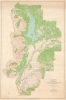
This is a 1963 U.S. Geological Survey map of Grand Teton National Park. The map illustrates a key development period where expanding tourism was presenting new challenges to the Park Service, which struggled to balance infrastructure, access, and development with environmental preservation. Among the most-visited national parks in the country, Grand Teton welcomes visitors all year and provides opportunities for numerous outdoor activities, including hiking and mountaineering, and is world-famous for trout fishing.A Closer Look
Depicting the entirety of the park, a broad red line highlights the park's borders. Jackson, Wyoming (often misnamed Jackson Hole) appears near the bottom border. Jackson Lake immediately draws the viewer's attention. The Teton Mountain Range occupies the western portion of the park, and its iconic peaks are named, and their elevations are provided. Moran, a town located within the park, is identified, as are numerous lodges, ranches, and campgrounds.Grand Teton National Park
Grand Teton National Park was established in 1929 in northwestern Wyoming. It is renowned for its stunning mountain landscapes and diverse wildlife. The park dates to efforts by conservationists like John D. Rockefeller Jr., who played a crucial role in expanding the park. Initially, only the Teton Range and some surrounding lakes were protected, but in the 1940s, Rockefeller quietly purchased over 35,000 acres of land in the Jackson Hole Valley and donated it to the federal government. This led to the park's expansion in 1950, two years before this map was made, creating the Grand Teton National Park as it is known today. The park preserves the dramatic Teton Range and the cultural history of Native Americans, early pioneers, and fur trappers who once inhabited the region.Publication History and Census
This map was created and published by the U.S. Geological Survey in 1963. This map is well represented in institutional collections.Cartographer
The United States Geological Survey (1878 - Present), aka the U.S.G.S., is a scientific agency of the United States government, which was founded in 1879. USGS scientists study the landscape of the United States, its natural resources, and the natural hazards that threaten it. The organization has four major science disciplines: biology, geography, geology, and hydrology. It is a bureau of the United States Department of the Interior and is the department's only scientific agency. Further Details...
Condition
Good. Soiling. 2 Closed tears extending .75 inch into printed area professionally repaired on verso. Text on verso.
References
OCLC 1065550884, 1306239500, 1398353879.