This item has been sold, but you can get on the Waitlist to be notified if another example becomes available, or purchase a digital scan.
1755 London Magazine Map of the Great Lakes (Michigan, Wisconsin, Illinois, Pennsylvania, Canada)
GreatLakes-kitchin-1755$200.00

Title
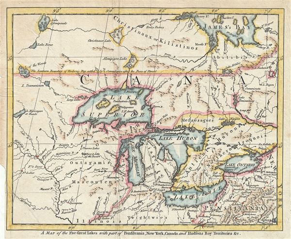
A Map of the Five Great Lakes, with Part of Pensilvania, New York, Canada and Hudson's Bay Territories &c.
1755 (undated) 8.5 x 10.5 in (21.59 x 26.67 cm) 1 : 3373000
1755 (undated) 8.5 x 10.5 in (21.59 x 26.67 cm) 1 : 3373000
Description
An interesting and uncommon 1755 French and Indian War Era map of the Great Lakes issued for the London Magazine. Centered on Lake Michigan, this map covers from St. James Bay to Pennsylvania and from the Mississippi River to New York, including all five of the Great Lakes. Numerous rivers are named and topography is rendered both by profile and shading (as in the unusual plateau in central Michigan).
Issued at the height of the French and Indian War, this map illustrates one of the most active theaters of war, with numerous fortifications and American Indian nations identified. Among the most important of these is for Quesne (For Duquesne), which inches into the border of the map at the Forks of the Ohio River. This fort was perceived as critical to controlling trade on the Ohio and its occupation of by the French significant heightened aggression in the region.
Cartographically this map follows many of the conventions, including the four fictional islands in Lake Superior, laid down by Jacques-Nicholas Bellin in his influential 1744 map of the same region. Bellin's apocryphal islands include: Philippeux, Pontchartrain, Maurepas, and St. Anne. These islands were invented three years earlier by the French historian and traveler Charlevoix, then subsequently immortalized by the cartographer Jacques-Nicholas Bellin. The islands were intended to honor Charlevoix' s personal patron, the Count of Maurepas, Jean-Frederic Phelypeaux. The largest of the three islands, Philippeaux, is named directly after the count. The second largest island, Pontchartrain, refers to Phelypeaux's family estate. The third island, which may in fact be a mismapping of the factual State Islands, is named after the count's seat, Maurepas. The fourth and smallest of the islands, St. Anne, references the count's patron saint. Charlevoix described the islands as being rich in minerals leading numerous explorers to search for them in vain. Bellin dutifully introduced the four islands to his map, and such was his influence that they were subsequently copied by most subsequent cartographers, including John Mitchell in his seminal 1755 wall map of North America. The highly regarded Mitchell map was used in negotiating the 1783 Treaty of Paris that formally concluded the American Revolutionary War. Therein, the apocryphal Philippeaux was assigned as a marker for the new United States - British America border thus setting the stage for later political strife.
This map was published by Robert Baldwin for the September 1755 edition of the London Magazine. Though no cartographer is named, it is highly likely this map was drawn and engraved by Thomas Kitchin, a known engraver for the London Magazine with whose distinctive style this map is consistent.
CartographerS
Thomas Kitchin (August 4, 1718 – June 23, 1784) was a London based engraver, cartographer, and publisher. He was born in London to a hat-dyer of the same name. At 14, Kitchin apprenticed under Emanuel Bowen, under whom he mastered the art of engraving. He married Bowen daughter, Sarah Bowen, and later inherited much of his preceptor's prosperous business. Their son, Thomas Bowen Kitchin, also an engraver joined the family business, which thereafter published in Thomas Kitchin and Son. From 1858 or so Kitchin was the engraver to the Duke of York, and from about 1773 acquired the title, 'Royal Hydrographer to King George III.' He is responsible for numerous maps published in the The Star, Gentleman's Magazine, and London Magazine, as well as partnering with, at various times, with Thomas Jefferys, Emmanuel Bowen, Thomas Hinton, Issac Tayor, Andrew Dury, John Rocque, Louis de la Rochette, and Alexander Hogg, among others. Kitchin passed his business on to his son, Thomas Bowen Kitchin, who continued to republish many of his maps well after his death. Kitchin's apprentices included George Rollos, Bryant Lodge, Thomas Bowen Kitchin, Samuel Turner Sparrow, John Page, and Francis Vivares. More by this mapmaker...
Richard Baldwin (December, 1724 - January, 1770) was an English bookseller and publisher active in London during the middle part of the 18th century. Baldwin is best known as the publisher of the London Magazine: or, Gentleman's Monthly Intelligencer, a monthly periodical. The London Magazine chronicled some of the most important events in the 18th century including the French and Indian War and the American Revolutionary War. It was also notable for being well illustrated by with maps by Thomas Kitchin and others. Upon his death in January of 1770, control of the London Magazine passed to his son Robert Baldwin (fl. 1746 - 1810). Eventually the firm was renamed Baldwin, Cradock & Joy, then simply Baldwin and Cradock. Learn More...
Source
London Magazine: or, Gentleman's Monthly Intelligencer, (London: Baldwin, Richard J.) Vol 24, September 1755.
Condition
Very good. Original fold lines visible.
References
Philips (America) p. 575. Streeter, F. J., Michigan Bibliography, no. 7879. Jolly, D., Maps in British Periodicals, LOND-97.