This item has been sold, but you can get on the Waitlist to be notified if another example becomes available, or purchase a digital scan.
1791 Bocage Map of Ancient Greece
Greece-bocage-1791$100.00

Title
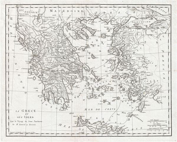
La Grece et ses Isles Pour le Voyagedu Jeune Anacharsis.
1791 (undated) 14.5 x 17.5 in (36.83 x 44.45 cm)
1791 (undated) 14.5 x 17.5 in (36.83 x 44.45 cm)
Description
This is an attractive 1791 map of Ancient Greece. It includes Crete, the islands of the Aegean Sean and the parts adjacent Turkey. Take from the early D'Anville map. Notes important cities and towns along with various other topographical features. Following the Battle of Corinth in 146 BC, the Greek peninsula came under Roman rule. The period from 31 BC and AD 180 in Greek history is described as the era of the Pax Romana. This was a period of peace and security when many Greek cities flourished, leading to cultural and economic progress. After the fall of the Western Roman empire, Greece became the center of the eastern Roman or Byzantium empire. However, following the conquest of the capital city of Constantinople, the Byzantium empire fell to the Turks in BC 1453. Greece would be under Ottoman rule for nearly 1,000 years until the Greek War of Independence in 1821. Prepared by M. Barbie de Bocage in 1791 to illustrate the Travels of Anacharsis.
Cartographer
Jean Denis Barbie du Bocage (1760 - 1825) and his son Jean-Guillaume Barbie du Bocage (1795 - 1848) were French cartographers and cosmographers active in Paris during late 18th and early 19th centuries. The elder Barbie du Bocage, Jean Denis, was trained as a cartographer and engraver in the workshops of mapmaking legend J. B. B. d'Anville. At some point Jean Denis held the post of Royal Librarian of France and it was through is associations with d'Anville that the d'Anville collection of nearly 9000 maps was acquired by French Ministry of Foreign Affairs. The younger Barbie du Bocage, Jean-Guillaume, acquired a position shortly afterwards at the Ministry of Foreign Affairs and, in time, became its head, with the title of Geographe du Ministere des Affaires Etrangeres. More by this mapmaker...
Source
Barbie du Bocage, J. D., Recueil de Cartes Geographiques Plans, Vues, et Medailles de l'Ancienne Grece, Reelatifs au Voyage du Jeune Anacharsis., (Paris, Chez Sanson et Compagnie), 1791.
Condition
Very good. Original platemark visible. Original fold lines visible. Blank on verso. Dark clean impression. Minor creasing.