1939 Selchow Pictorial Map of Greenwich, Connecticut
Greenwich-selchow-1939-2$1,000.00

Title
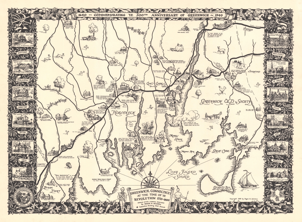
Greenwich, Connecticut at the Time of Ye Revolution 1775 - 1800. 1640 - Commemorating Ye 300th Anniversary of Greenwich - 1940.
1939 (dated) 20.5 x 28 in (52.07 x 71.12 cm)
1939 (dated) 20.5 x 28 in (52.07 x 71.12 cm)
Description
This is a rare 1939 Roger Selchow pictorial map of Greenwich, Connecticut, created to celebrate the 300th anniversary of its founding.
A Closer Look
Depicting Greenwich from Byram Point to Stamford and from The Fincherie Ezekiel Finch House to Elisabeth's Neck and Long Island Sound, Selchow captures the area during the American Revolutionary War (1775 - 1783). Homesteads, taverns, and mills are identified and dated. Stars denote surviving historic buildings. The Indian village, where a 1644 massacre perpetrated by Dutch colonists as part of Kieft's War, is noted. So, too, is the site on Elizabeth's Neck where Captain Daniel Patrick and Robert Feaks landed on July 18, 1640.Greenwich and the American Revolution
Most of the annotations highlight events during the American Revolutionary War. Selchow identifies houses plundered and burned by the British and the sloop burned during General Tryon's February 26, 1779, raid. Selchow adds that General Tryon was almost shot in the Evenezer Mead Tavern. A vignette of people firing a cannon remarks that 'at Chimney Corner, citizens drove off British sloop with a cannon'.Charming Details
Apart from facts concerning the Revolution, illustrations of fences, flowers, trees, horseback riders, farmers, and wildlife provide charm. The whole is surrounded by a pictorial border decorated with crops along the top and sea creatures along the bottom - underscoring Greenwich's dual agrarian and maritime connections. The title is flanked by a Revolutionary War soldier armed with a musket and an American Indian holding a fishing net and a spear. Six views of 'historic buildings erected after 1800' are illustrated along the left border, and another six views of 'buildings of great fame and beauty' are illustrated along the right.Publication History and Census
This map was created by Roger H. Selchow and published in 1939. Selchow also published a companion map of Northern Greenwich (Geographicus: northerngreenwich-selchow-1948-2). The OCLC notes two examples which are part of the collections at the Connecticut Historical Society and the New York Public Library. We are aware of only two other examples that have entered the private market.Cartographer
Roger Hoffman Selchow (February 13, 1911 - 1995) was an American artist. Born in Greenwich, Connecticut, Selchow is best known for his paintings of geometric abstractions. Selchow studied at Columbia University. His work is part in the collections of the Metropolitan Museum of Art in New York City, the Brooklyn Museum in Brooklyn, the Wadsworth Atheneum in Hartford, Connecticut, and the Musée des Beaux-Arts in Liège, Belgium, among others. More by this mapmaker...
Condition
Very good.
References
OCLC 38290058.