This item has been sold, but you can get on the Waitlist to be notified if another example becomes available, or purchase a digital scan.
1780 Bellin Map of Grenada
Grenada-bellin-1780$100.00

Title
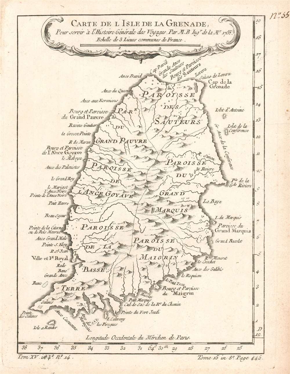
Carte de l'Isle de la Grenade. Pour servir à l'Histoire Générale des Voyages.
1780 (dated) 9 x 6.75 in (22.86 x 17.145 cm) 1 : 180000
1780 (dated) 9 x 6.75 in (22.86 x 17.145 cm) 1 : 180000
Description
This is a 1780 Jacques-Nicolas Bellin map of Grenada. Depicting the entire island, coastal points, islands, and harbors are labeled. The island is divided into parishes and its many rivers and mountains are illustrated. Fort Royal, the French colonial capital, is labeled.
Grenada during the 18th Century
Grenada became a French colony in 1654, after six years of war following the French 'invasion' of 1649. Fighting continued throughout the 17th century between the French on Grenada and the Caribs on present-day Dominica and St. Vincent and the Grenadines. British forces captured Grenada in 1762 during the Seven Years' War and the French officially ceded the island to Great Britain in 1763 as part of the terms of the Treaty of Paris. The island became a battleground once again during the American Revolution, when the French recaptured the island after the brutal Battle of Grenada in July 1779. Even so, Grenada was restored to Britain as part of the 1783 Treaty of Versailles. In 1795 - 96, a pro-French revolt erupted over dissatisfaction with British rule, but the British defeated the uprising.Publication History and Census
This map was originally created by Jacques-Nicolas Bellin in 1758 for inclusion in Abbé Prévost's Histoire Générale des Voyages. The present example was published by Jean-François de la Harpe in 1780 in his Abrégé de l'Histoire Générale des Voyages. Three examples are cataloged in OCLC and are part of the institutional collections at the University Library in Augsburg, Germany; the University Library in Munich, Germany; and the Bavarian State Library in Munich, Germany.Cartographer
Jacques-Nicolas Bellin (1703 - March 21, 1772) was one of the most important cartographers of the 18th century. With a career spanning some 50 years, Bellin is best understood as geographe de cabinet and transitional mapmaker spanning the gap between 18th and early-19th century cartographic styles. His long career as Hydrographer and Ingénieur Hydrographe at the French Dépôt des cartes et plans de la Marine resulted in hundreds of high quality nautical charts of practically everywhere in the world. A true child of the Enlightenment Era, Bellin's work focuses on function and accuracy tending in the process to be less decorative than the earlier 17th and 18th century cartographic work. Unlike many of his contemporaries, Bellin was always careful to cite his references and his scholarly corpus consists of over 1400 articles on geography prepared for Diderot's Encyclopedie. Bellin, despite his extraordinary success, may not have enjoyed his work, which is described as "long, unpleasant, and hard." In addition to numerous maps and charts published during his lifetime, many of Bellin's maps were updated (or not) and published posthumously. He was succeeded as Ingénieur Hydrographe by his student, also a prolific and influential cartographer, Rigobert Bonne. More by this mapmaker...
Source
De la Harpe, Abrégé de l'histoire générale des voyages. (Paris) 1780.
Condition
Very good. Even overall toning. Blank on verso.
References
OCLC 231963766.