This item has been sold, but you can get on the Waitlist to be notified if another example becomes available, or purchase a digital scan.
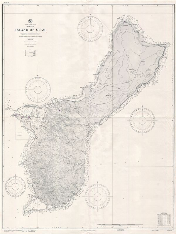
1945 World War II (WWII) U.S. Navy Map of Guam
GuamWWII-navy-1945$100.00

Title
North Pacifc Ocean Marianas Island of Guam.
1945 (dated) 45 x 34 in (114.3 x 86.36 cm)
1945 (dated) 45 x 34 in (114.3 x 86.36 cm)
Description
This is a scarce World War II (WWII) era 1945 map of Guam issued by the U.S. Navy Hydrographic Office shortly after the 1944 recapture of the island by U.S. military forces. Guam, long an important stopping point for trans-Pacific voyages, was nominally under U.S. control since the 1898 Spanish-American War. In 1941, early in World War II, Guam was seized by the Japanese who saw it as a kind of Pacific Gibraltar. The Japanese occupation of Guam was particularly brutal for the indigenous Chamorro people who were steadfastly loyal to the United States. This chart was originally drawn in 1925 and has been updated to 1945 with minor corrections and alternation. Issued by the U.S. Navy as Chart no. 2186.
Cartographer
United States Hydrographic Office (1866 - 1962) was a brach of he U.S. Navy that prepared and published maps, charts, and nautical books to aid in navigation. Before the establishment of the Hydrographic Office in 1866, U.S. navigators were almost entirely dependent on British charts. There had been a few private enterprises that had prepared and published charts, but none had been able to do so profitably. The Office was established 'for the improvement of the means of navigating safely the vessels of the Navy and of the mercantile marine, by providing, under the authority of the Secretary of the Navy, accurate and cheap nautical charts, sailing directions, navigators, and manuals of instructions for the use of all vessels of the United States, and for the benefit and use of navigators generally.' This way the Navy Department could furnish navy and merchant ships with charts illustrating the results of surveys and explorations undertaken by naval officers. The charts were priced to cover the cost of paper and printing alone, not preparation. Its main objective was to survey foreign coasts, as the Coast and Geodetic Surveys were responsible for surveying domestic waters. The Hydrographic Office was transferred from the Department of the Navy to the Department of Defense in 1949 and was replaced by the Naval Oceanographic Office in 1962. More by this mapmaker...
Condition
Very good condition. Appears to have been folded at some point.