This item has been sold, but you can get on the Waitlist to be notified if another example becomes available, or purchase a digital scan.
1890 Bianconi Map of Guatemala
Guatemala-bianconi-1890$900.00

Title
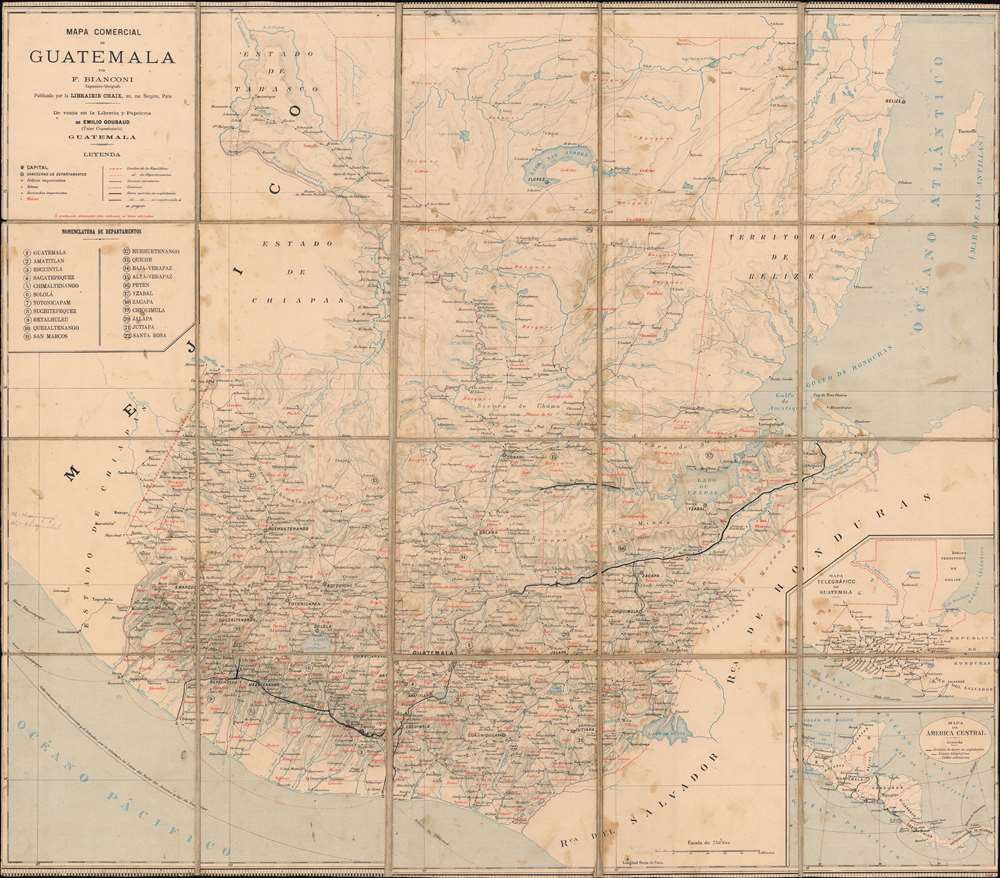
Mapa Comercial de Guatemala.
1890 (undated) 26.75 x 30.25 in (67.945 x 76.835 cm) 1 : 750000
1890 (undated) 26.75 x 30.25 in (67.945 x 76.835 cm) 1 : 750000
Description
This is a c. 1890 F. Bianconi economic map of Guatemala. As a commercial map, Guatemala's rich natural resources are extolled from Tikal to the Pacific Ocean. Small italic print in both French and Spanish indicates the different products produced, grown, harvested, or raised. These include sarsaparilla, vanilla, mahogany, cedar, pastureland, cotton, wheat, sugarcane, and other grains. 'Forests' are also indicated as important sources of cedar, mahogany, and other tropical woods.
A Closer Look
Highly detailed, cities, towns, and villages are labeled, including Guatemala City, Jutiapa, and Quezaltenango. All twenty-two of Guatemala's departments are numerically identified and correspond with an index along the left border. Roads, carriage roads, and railways, both in operation and under construction, are also illustrated. Rivers and lakes, including Lake Guija and Lake San Andres, are illustrated and labeled, as is Guatemala's topography.Publication History and Census
This map was created by F. Bianconi and published c. 1890 by the LIbrairie Chaix in Paris, France. It was sold by the Libreria y Papeleria de Emilio Goubaud in Guatemala. We note two examples of the present map cataloged in OCLC: Harvard and the Bibliothèque nationale de France. An English language edition was copyrighted by William M. Bradley in 1891 and published by the Bureau of the American Republics in Bulletin No. 32 (January 1892) entitled simply Guatemala.Cartographer
F. Bianconi (fl. c. 1870 - 1900) was a cartographer active in France during the late 19th century. He prepared a series of maps of South American countries, including Colombia and Equador, Bolivia, Venezuela, Chile, and Uruguay and Argentina. More by this mapmaker...
Condition
Good. Dissected and mounted on linen in twenty (20) panels. Some soiling. Wear along original linen fold lines. Map cut up to or past border, but not effecting any text.
References
OCLC 1096189733.