This item has been sold, but you can get on the Waitlist to be notified if another example becomes available, or purchase a digital scan.
1943 Mercier Pictorial Map of the North Pole during World War II
GuerreduPole-mercier-1943$200.00

Title
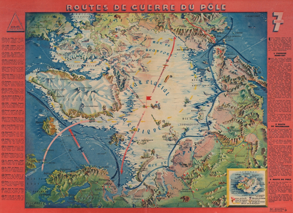
Routes de Guerre du Pôle.
1943 (undated) 16 x 22.25 in (40.64 x 56.515 cm) 1 : 15700000
1943 (undated) 16 x 22.25 in (40.64 x 56.515 cm) 1 : 15700000
Description
This is a 1943 Jacques Mercier pictorial map of the North Pole, published in Lyon during World War II (1939 - 1945). The map posits a future where aviators could travel via the North Pole between Asia and North America. Though this is the shortest route between the continents, it was a technological impossibility at the time of publication.
A Closer Look
The map depicts the northern portion of the Earth with the North Pole at center. Labrador, Canada, and Alaska appear along the top border, Greenland is just to the left of center, and Europe and Asia circle the bottom and right sides. Red arrows highlight the air routes discussed along the right border, while blue arrows illustrate the Northeast Passage and the Murmansk route. Although not feasible when this map was published, these air routes are today known as Great Circle Routes and are routine air-routes between Asia and America. Twenty-three locations are marked numerically and correspond with an index along the left side. These mark historical events, cultural aspects of life in the northern extremes of the Earth, and the current military uses for the Arctic. Illustrations of seals, whales, polar bears (one of whom is attacking an explorer near number 12), and other northern wildlife add character.Publication History and Census
This map was drawn by Jacques Mercier and published in the January 10, 1943, edition of 7 Jours. We note only a handful of instances when the separate map has appeared on the private market. An example is part of the David Rumsey Collection but is cataloged as being published in 1939 instead of 1943.Cartographer
Jacques Mercier (19xx - 19xx) was a cartographer most likely of French origin who created pictorial maps for magazines in the 1940s and 1950s. His work appeared in the magazines 7 Jours and Je Cherche in the 1940s and we have found a reference to at least one map that was published in Paris-Match in the 1950s. A few of his maps that are part of the collection at the Bibliothèque national de France appear to have been separately published by Editions Gutenberg in Lyon in 1945. More by this mapmaker...
Source
7 Jours January 10, 1943.
7 Jours was a French weekly magazine published in Lyon from October 6, 1940 until April 2, 1944, when its last issue was published. The magazine was created by French publisher Jean Prouvost (April 24, 1885 - October 18, 1978), who had directed Paris-Soir, Marie Claire, and Match. 7 Jours published news stories and serialized novels, sometimes as many as three novels per issue. In its first issue, Prouvost tried stated that 7 Jours was going to take what he viewed as the middle road, and not completely side with either the Resistance or the collaborationist Vichy government. This tactic was not popular with either side (although he did manage to keep publishing even after the Nazi invasion of the Unoccupied Zone), and after the war Prouvost was arrested, but his case was dismissed as a non-lieu.
Condition
Very good. Closed minor edge tears professionally repaired on verso. Centerfold separation repaired on verso.
References
Rumsey 15801.001.