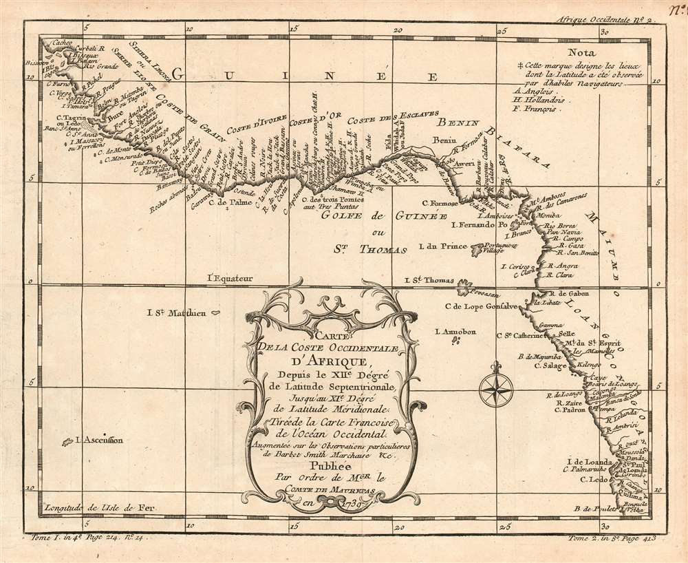
1780 Bellin Map of the Guinea Coast of Africa, from Guinea-Bissau to Angola
Guinea-bellin-1780$450.00

Title
Carte De La Coste Occidentale D'Afrique, Depuis le XII.e Dégré de Latitude Septentrionale, Jusqu'au XI.e Dégré de Latitude Méridionale. Tirée de la Carte Francoise de l'Océan Occidental. Augmenteé sur les Observations particulieres de Barbot Smith Marchaise etc. Publiee Par Ordre de MGR. le Comte De Maurepas en 1738.
1780 (undated) 8 x 10 in (20.32 x 25.4 cm) 1 : 14000000
1780 (undated) 8 x 10 in (20.32 x 25.4 cm) 1 : 14000000
Description
This is a 1780 Bellin map of the Guinea Coast of west Africa, from what is now Guinea-Bissau as far south as the northern coast of Angola. The map therefore includes, and indeed labels, the regions by resources extracted during the age of discovery and exploration. Revealed on the map are the Coste de Grain, the Coste d'Ivoire, the Coste d'Or, and the Coste des Esclaves. The map includes notations indicating places whose latitudes had been observed by 'skilled navigators,' and includes a letter-key showing trade forts - including the infamous Castel de la Mina - belonging respectively to the English, the Dutch, and the French.
Bellin based this 1780 chart on an intermediate work, produced by the English mapmaker Thomas Kitchin in 1759. A cursory translation of the title of that work is revealing:
Wheels Within Wheels
For his sources, Bellin makes mention of his own superb 1739 chart of the southern Atlantic Ocean, Carte Reduite de l'Ocean-Meridional, produced 'Par Ordre' of the Count de Maurepas. He also notes that the chart is 'augmented with the particular observations of Barbot, Smith, Marchaise etc.' These, then, are the sources for the details of the trade forts, which do not appear on the 1739 chart.Bellin based this 1780 chart on an intermediate work, produced by the English mapmaker Thomas Kitchin in 1759. A cursory translation of the title of that work is revealing:
A chart of the western coast of Africa, from the twelfth degree of latitude north to the eleventh degree south, with the adjacent islands : drawn from the French chart of the Western Ocean published in 1738, by order of the Count de Maurepas ; improved from particular surveys publish'd by Barbot, Smith, Marchaise and others.So it would appear that Bellin's 1780 map is copied from Kitchin's 1759 map, whose geographical information is based on Bellin's 1738 map.
Publication History and Census
The map was included in Harpe's 1780 abridged edition of Prévost's Histoire générale des voyages. This map appears on the market from time to time, but OCLC lists only two copies of the separate map (at the Bayerische Staatsbibliothek, and the Universitatbibliothek LMU Munchen) although inconsistencies in cataloguing mean this number may be higher. Prévost's Histoire and Harpe's abridged version of it are well represented in institutional collections.Cartographer
Jacques-Nicolas Bellin (1703 - March 21, 1772) was one of the most important cartographers of the 18th century. With a career spanning some 50 years, Bellin is best understood as geographe de cabinet and transitional mapmaker spanning the gap between 18th and early-19th century cartographic styles. His long career as Hydrographer and Ingénieur Hydrographe at the French Dépôt des cartes et plans de la Marine resulted in hundreds of high quality nautical charts of practically everywhere in the world. A true child of the Enlightenment Era, Bellin's work focuses on function and accuracy tending in the process to be less decorative than the earlier 17th and 18th century cartographic work. Unlike many of his contemporaries, Bellin was always careful to cite his references and his scholarly corpus consists of over 1400 articles on geography prepared for Diderot's Encyclopedie. Bellin, despite his extraordinary success, may not have enjoyed his work, which is described as "long, unpleasant, and hard." In addition to numerous maps and charts published during his lifetime, many of Bellin's maps were updated (or not) and published posthumously. He was succeeded as Ingénieur Hydrographe by his student, also a prolific and influential cartographer, Rigobert Bonne. More by this mapmaker...
Source
De la Harpe, Abrégé de l'histoire générale des voyages. (Paris) 1780.
Condition
Very good condition; lightly toned margins. Else excellent with a bold strike and generous margins.
References
OCLC 163337116. Afriterra 1763.