This item has been sold, but you can get on the Waitlist to be notified if another example becomes available, or purchase a digital scan.
1876 Walker Map of Hackensack, New Jersey
HackensackNJ1-walker-1876$87.50

Title
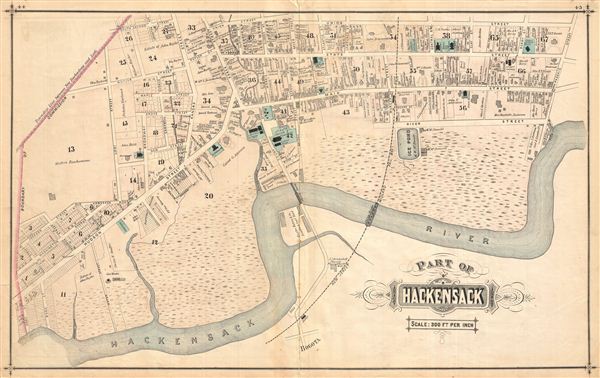
Part of Hackensack.
1876 (undated) 16.75 x 27.25 in (42.545 x 69.215 cm)
1876 (undated) 16.75 x 27.25 in (42.545 x 69.215 cm)
Description
Very detailed map of part of Hackensack (1 of 2), New Jersey, showing property boundaries, owners' names and individual building footprints. Published as plates 44-45 in Walker & Pease's exquisite topographical, illustrated, historical, descriptive Atlas of Bergen County, New Jersey, 1876. Verso contains beautifully rendered lithographic views of the Bank of Bergen County, First National Bank, and a private residence, all enlivened with children playing, horses and carriages in motion, ladies walking, gentlemen talking, dogs running.
Source
Walker, A. H., and Pease, C. C. Atlas of Bergen County, New Jersey, 1876.
Condition
Good. Even overall toning. Original centerfold exhibits some wear and in verso reinforcement. Minor discolorations here and there. Edge wear mostly confined to margins.
References
Phillips (Atlases) #2152.