This item has been sold, but you can get on the Waitlist to be notified if another example becomes available, or purchase a digital scan.
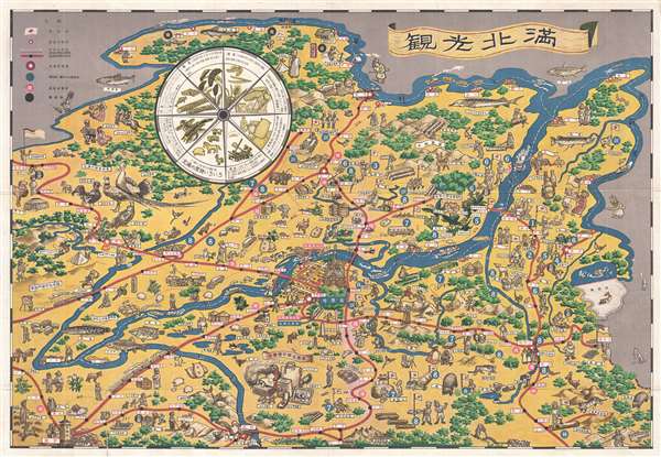
1939 Nishijima Pictorial Map of Harbin, Northern Manchuria
HarbinManchuria-nishijimia-1939$425.00

Title
滿北光觀 / North Manchu Sightseeing. / Kankō Hokuman
1939 (dated) 20 x 29 in (50.8 x 73.66 cm)
1939 (dated) 20 x 29 in (50.8 x 73.66 cm)
Description
A charming 1939 pictorial map of Heilongjiang (Harbin), Northern Manchuria, China. This map was issued by the Japanese run Harbin Railroad Foundation to promote tourism and commerce in and around the city of Harbin, in Northern Manchuria. Harbin, with its iconic Russian Orthodox Church, appears at center, from which an elaborate railroad network extending in all directions. The vignettes are wonderfully rendered and range from pictures of resources, such as fish, livestock, and game, to depictions of local life and illustrations of excellent regional souvenirs. Japanese operated business, which predominated in the southwest part of the map, are identified by a Japanese flag. A great wheel in the upper left breakdown the Manchuria's production.
The cheerful aspect of this map is diminished by the presents of dour, swarthy, and threatening bayonet bearing Soviet soldiers along the Manchu-Mongolia border. In May of 1839 tensions between Japanese forces occupying Manchuria and the Russian Soviets reached their apex. Shortly after this map was issued, in late May of 1839, a little-known war broke out between the Japanese and Soviet forces in Manchuria. Although rarely mentioned in history books, this was no mere border skirmish, rather it was a full-fledged war involving more than 100000 troops and some 30,000 – 50,000 men killed or wounded. The conflict reached its head in the Nomonhan Incident or Battle of Khalkhin Gol, a climactic battle fought between August 20 and August 31 of 1939 in which Russian forces soundly defeated the Japanese. It is no coincidence that this conflict coincided with the signing of the German-Soviet Nonaggression Pact of August 23, 1939. The last thing the Soviets wanted was a two-front war. Stalin and the Russian generals realized that if they could secure the western front, they could concentrate on expanding their interests in Asia, a war they doubtless believed they could easily win. This treaty had far reaching implications, including giving Hitler a green light to invade Poland.
This map was published by the Harbin Railroad and drawn by T. Nishijima in May of 1839. We have been able to isolate only one other example in the Harvard-Yenching Library.
Condition
Very good condition. Blank on verso. Bright and clean. A couple of minor verso reinforcement along original fold lines.
References
OCLC 939522566. Harvard University, HOLLIS 014609582.