This item has been sold, but you can get on the Waitlist to be notified if another example becomes available, or purchase a digital scan.
1863 Weyss Map of Harper's Ferry, West Virginia During the American Civil War
HarpersFerry-weyss-1863$200.00

Title
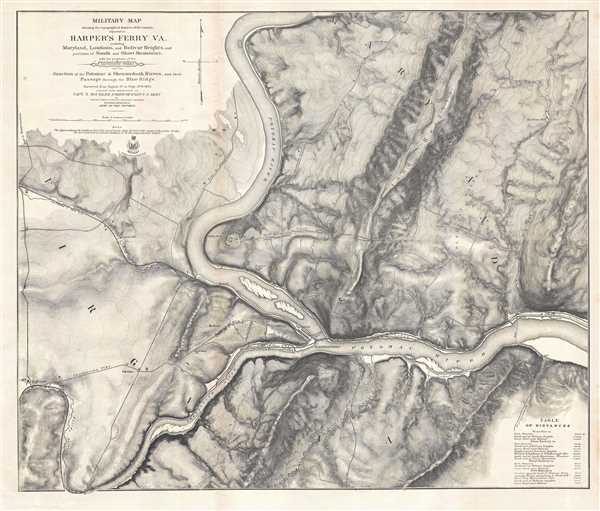
Military Map showing the topographical features of the country adjacent to Harper's Ferry VA. Including Maryland, Loudoun, and Bolivar Heights, and portions of South and Short Mountains, with the positions of the Defensive Works also the Junction of the Potomac and Shenandoah Rivers, and their Passage through the Blue Ridge.
1863 (dated) 25.5 x 30 in (64.77 x 76.2 cm) 1 : 15840
1863 (dated) 25.5 x 30 in (64.77 x 76.2 cm) 1 : 15840
Description
This is an extraordinary separate issue 1863 John E. Weyss map of Harper's Ferry, West Virginia, created during the American Civil War. One of the best maps of the region created at the time, particularly from a topographic point of view, the vicinity of Harper's Ferry is depicted from Halltown to Weverton and from Salomon's Gap to Waldro's School House.
Harper's Ferry and the American Civil War
Harper's Ferry was a hotbed of violence during the Civil War, and even before the war started. John Brown attacked and captured the Federal Arsenal in Harper's Ferry in October 1859 in the hope of igniting a slave rebellion. This assault was then put down by Colonel Robert E. Lee. Over the course of the war, from 1861 until 1864, possession of Harper's Ferry would change between the Union and the Confederacy numerous times, the last being General Philip Sheridan's occupation of the town in August 1864 as a base of operations for his pursuit of Confederate General Jubal Early in the Shenandoah Valley. It is important to note that West Virginia, a region that was sympathetic to the Union cause, seceded from the state of Virginia in 1861 following Virginia's secession from the United States. It is intriguing that this map was created from surveys that took place in August and September 1863, because West Virginia officially became a state in June of that year. Thus, this is probably the first detailed map of Harper's Ferry, West Virginia.
This map was created by John E. Weyss under the direction of Captain Nathaniel Michler in 1863.
Cartographer
John E. Weyss (1820 - June 24, 1903) was an Austrian-American illustrator, cartographer, and engineer. Born in Vienna, Weyss immigrated to the United States in 1848 and settled in New York. He served as a member of the U.S. Government's Mexican Boundary Survey (1849 - 1855), led by Major William Hemsley Emory, because of his training as an illustrator. In the capacity of a civilian artist working for the army, Weyss contributed several illustrations for Emory's report, which was published in 1857-59. Weyss is also credited on eleven of the report's maps. At the outbreak of the American Civil War, Weyss held a position as a civil engineer for the state of Kentucky. Weyss received a commission as a major from the Governor of Kentucky and, due to his professional experience, was assigned to the staff of Captain Nathaniel Michler, the chief topographical officer in the Army of the Ohio. In this role he did survey work for maps of the vicinity of Shiloh and Corinth, both sites of major Civil War battles. Weyss then joined Captain Michler when he moved to the staff of General Rosecrans in late 1862, for whom they made a series of maps of the Battle of Stones River. Weyss and Michler were then transferred to the Army of the Potomac in May, 1863. One of Weyss's first assignments for the Army of the Potomac was a map of the vicinity of Harper's Ferry, Virginia, for which he produced a highly detailed map of the very complex topography of the region. Soon, Weyss was made responsible for the day-to-day detailed mapping during the siege at Petersburg. After the war, Weyss served as the principal surveyor under the direction of Michler during the creation of the atlas Military maps illustrating the operations of the armies of the Potomac and James, May 4th 1864 to April 9th 1865, that was published in 1869. Weyss served the U.S. Army Corps of Engineers for another twenty years, until he retired sometime in the 1880s. Weyss died on June 4, 1903, in Washington, D.C. More by this mapmaker...
Condition
Very good. Even overall toning. Blank on verso.
References
Stephenson, R. W., Civil War Maps; an Annotated List of Maps and Atlases in Map Collections of the Library of Congress, 699. Rumsey 3874.000. OCLC 19733822.