This item has been sold, but you can get on the Waitlist to be notified if another example becomes available.
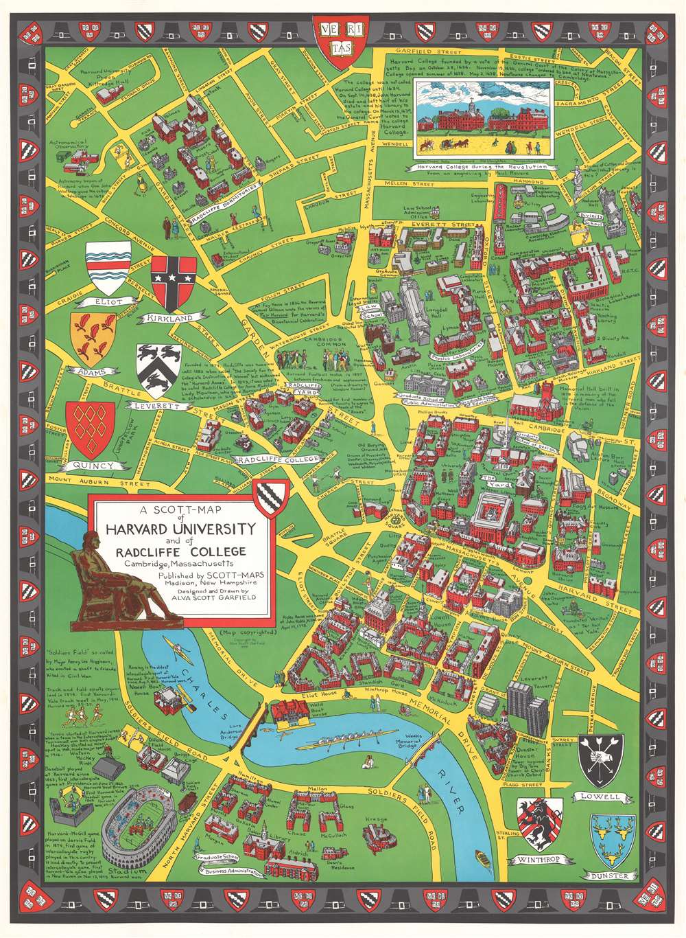
1959 Garfield Pictorial Map of Harvard University and Radcliffe College
HarvardRadcliffe-garfield-1959-2$325.00

Title
A Scott-Map of Harvard University and of Radcliffe College Cambridge, Massachusetts.
1959 (dated) 32.5 x 24 in (82.55 x 60.96 cm)
1959 (dated) 32.5 x 24 in (82.55 x 60.96 cm)
Description
A delightfully whimsical 1959 Alva Scott Garfield pictorial map Harvard University and Radcliffe College, Cambridge, Massachusetts (Boston). Centered on Harvard Square and presented from an acute 'view' perspective, this map covers Cambridge in the vicinity of Harvard and parts of adjacent Alston. Iconic Harvard buildings are identified throughout, including Radcliffe Dormitories, Physics Laboratories, Law School, Graduate School of Business Administration, Stadium, Lowell House and Memorial Hall. There are also numerous fascinating annotations, such as commentary in the lower left describing the history of intercollegiate rugby, baseball, and hockey - often boasting of Harvard victories. A vignette in the upper right, based upon a drawing by Paul Revere, reveals how Harvard appeared during the American Revolutionary War. Surrounding the map are armorial crests identifying the founding fathers of Boston. The crests of the various colleges are shown, and the University Veritas crest and pilgrim hats decorate the border.
Publication History and Census
This map was copyrighted and printed in Madison, New Hampshire in 1959 by 1927 Radcliffe alumna Alva Scott Garfield. Some have suggested that the presence of the Leverett Towers, in the lower right, indicate a print date later than the copyright date, but there is no evidence of this in the form of known edition variations. More likely Garfield was merely proactive in including buildings then under construction. We note an example of this map with David Rumsey Map Collection, but otherwise, it does not appear in the OCLC.Cartographer
Alva Scott Garfield (1902 – 1993), a.k.a. Alva Scott Mitchell, was a New England based writer, academic, and artist active in the middle part of the 20th century. Garfield graduated from Wellesley College. She also attended Radcliffe College in the late 1920s. Her first map appears to have been the Newe Mapp of Wellesley, published in 1926, and described as 'so delightful that every Wellesley and Dana girl will surely want one.' From about 1949, Garfield produced a series of whimsical pictorial maps, referred to collectively as 'Scott-Maps,' of various Mid-Atlantic and New England locations, including Harvard, Boston, Concord, Salem, Cape Code, Maine, and New Jersey. More by this mapmaker...
Condition
Very good.
References
Rumsey 8777.000. OCLC 1039433681.