This item has been sold, but you can get on the Waitlist to be notified if another example becomes available, or purchase a digital scan.
1940 Iglesias Panoramic Map of Havana, Cuba
Havana-iglesias-1940$125.00

Title
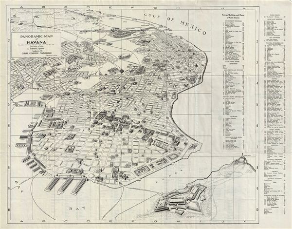
Panoramic Map of Havana. / Plano Panoramico de la Habana.
Description
A beautiful 1940 Cuban Tourist Commission first english edition panoramic map of Havana, Cuba. The map covers from Rancho Boyeros to San Pedro. Also includes the La Cabana Fortress and the Morro Castle. A key on the right of the map details various places of public interests, including important buildings, churches, beaches, theatres, hotels, hospitals, fortresses, townships, etc. On the verso this map features a list of street names arranged alphabetically. The map is highly detailed and shows individual buildings, street names, house numbers, parks, squares, piers, monuments, etc. Also shows the routes for the launch services to Casa Blanca, Regla and La Cabana Fortress.
This map represents the glory days of Cuban-American relations when luminaries like earnest Hemmingway dined at the Flordita Hotel and sipped Mai Tai cocktails at Trader Vic. Within the next 20 years Cuba would transform, under Castro's harsh socialist reforms, from the world's playground to an impoverished backwater.
This map is the 1940 first english edition of the Panoramic Map of Havana (Plano Panoramico de la Habana) by Ramiro e. Iglesias, published by the Cuban Tourist Commission (Corporacion Nacional del Turismo), Havana.
Condition
Very good. Original foldlines. Verso contains street names and prints of front and back cover of folded map.