
This item below is out of stock, but another example (left) is available. To view the available item, click "Details."
Details
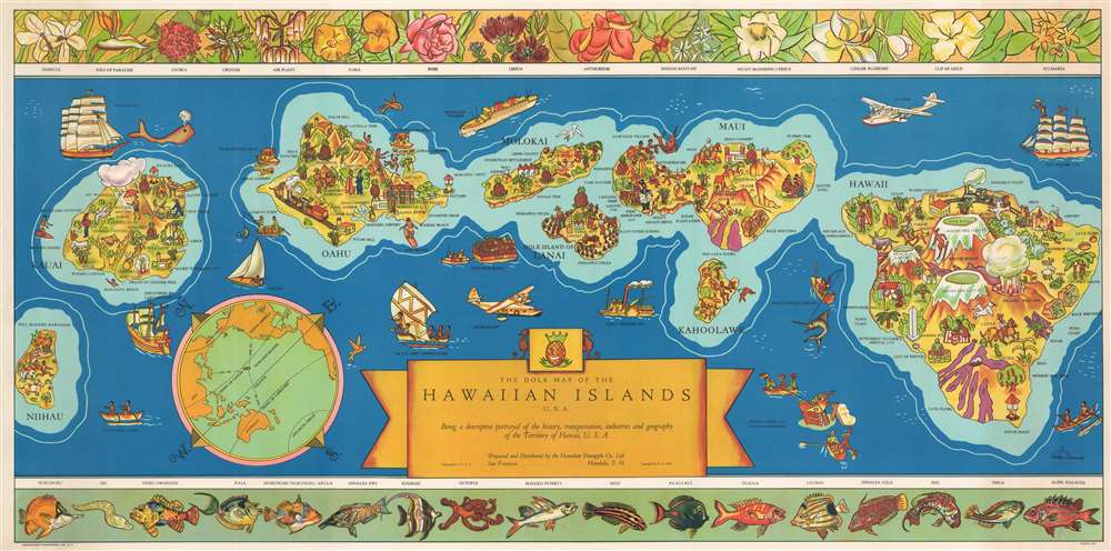
1937 Parker Edwards Dole Pineapple Map of Hawaii
$950.00
1937 Parker Edwards Dole Pineapple Map of Hawaii
Hawaii-dole-1937-3$425.00

Title
The Dole Map of the Hawaiian Islands U.S.A. Being a descriptive portrayal of the history, transportation, industries and geography of the Territory of Hawaii, U.S.A.
1937 (dated) 18.25 x 36.5 in (46.355 x 92.71 cm) 1 : 429000
1937 (dated) 18.25 x 36.5 in (46.355 x 92.71 cm) 1 : 429000
Description
One of the most iconic pictorial maps of Hawaii from its territorial period. This 1937 Parker Edwards pictorial map of the Hawaiian Archipelago was issued by the Dole Pineapple Company to highlight the islands and Dole's business interests. Depicting the Hawaiian Islands of Hawaii, Maui, Kahoolawe, Lanai, Molokai, Oahu, Kauai, and Niihau, pictorial vignettes decorate each island and relate scenes of daily life, tourist 'attractions,' and Hawaiian history. On Hawaii, for example, each volcano is labeled with elevations provided. The lava flows from the many eruptions are illustrated as well. Pearl Harbor - not yet the site of an infamous attack - is labeled. Several aspects of Dole's operation in the islands, including pineapple plantations, Dole canneries, etc. also are depicted. The upper border includes drawings of Hawaiian flora. In contrast, the lower border highlights resident sea life.
Publication History and Census
This map was printed in 1937 by the Independent Pressroom of San Francisco and stands as one of the most iconic maps of Hawaii published in the 20th century. It was widely admired and, in 1950, inspired Dole to contract a second stylistically similar map. Two examples are cataloged in OCLC and the map makes occasional market appearances.Cartographer
Parker Edwards (1911 - September 17, 1987) was a Hawaii based painter and illustrator. Edwards worked primarily in the medium of watercolors and was known for his "tiki" inspired imagery. Edwards was the third husband of the well-known writer, Peggy Bracken. In cartographic circles he is known for his iconic pictorial map of the Hawaiian Islands issued for the Dole Pineapple Company. More by this mapmaker...
Condition
Very good.
References
Rumsey 8504.000. OCLC 953572641.