This item has been sold, but you can get on the Waitlist to be notified if another example becomes available, or purchase a digital scan.
1906 Donn Map of Hawaii, Hawaiian Islands
Hawaii-donn-1906$550.00

Title
Hawaii Hawaiian Islands.
1906 (dated) 36.5 x 32 in (92.71 x 81.28 cm) 1 : 182000
1906 (dated) 36.5 x 32 in (92.71 x 81.28 cm) 1 : 182000
Description
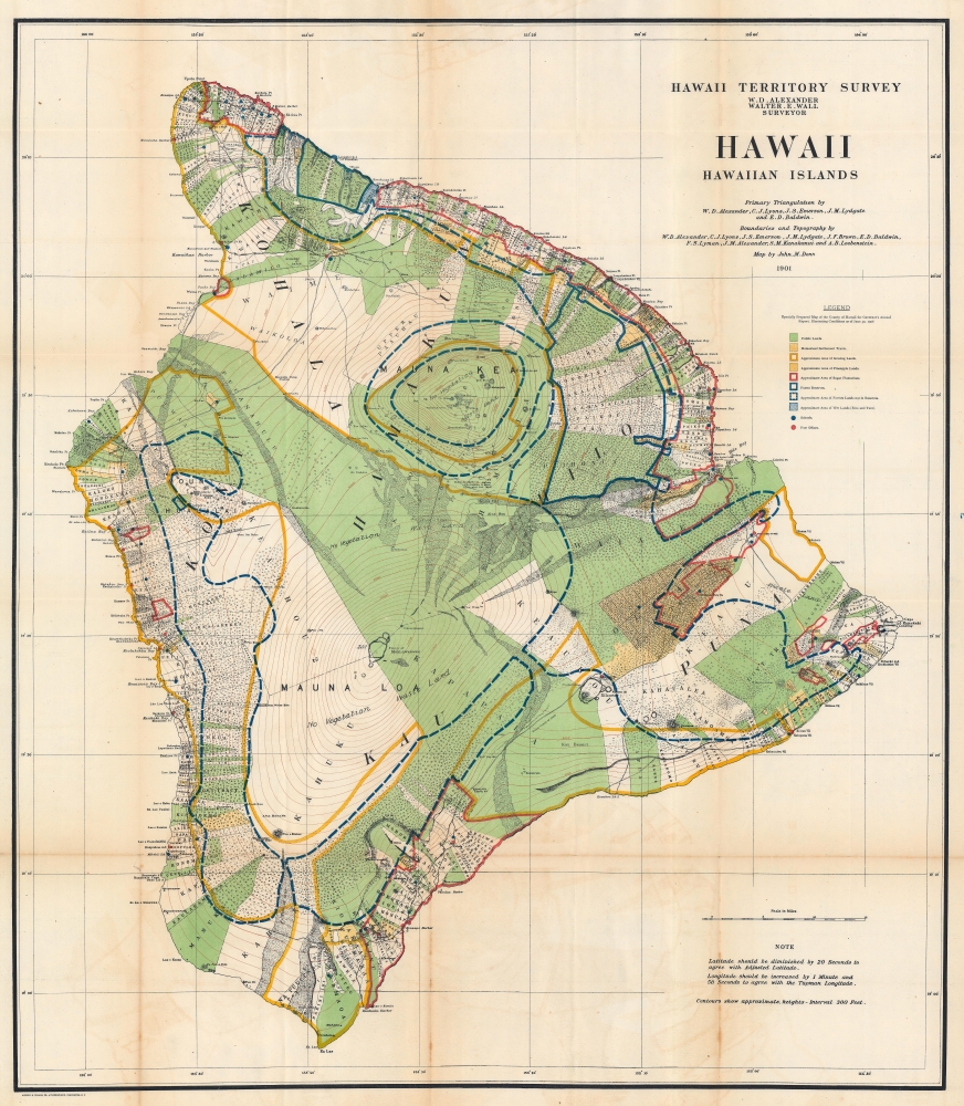
This is a 1906 John M. Donn map of Hawaii, Hawaiian Islands. This map represents the first comprehensive modern survey of Hawaii.
A Closer Look
This U.S. Government map focuses on land use on Hawaii. It incorporated a complex coding system to illustrate public lands, homestead settlement tracts, grazing lands, pineapple lands, sugar plantations, forest reserves, forested land that was not part of a reserve, and wetlands. Schools and post offices are also noted. Specific homesteads are identified by name. Lava flows from Mauna Loa and are labeled by year. The notations 'no vegetation' and 'waste land' appear on Mauna Loa and Mauna Kea, although they are conspicuously absent around Kilauea. Hilo and the Hilo Railroad are both labeled.Hawaiian Territorial Survey
The Hawaiian Territorial Survey came into existence in 1901, three years after the United States annexed the archipelago and took the place of the Hawaiian Government Survey. (The Hawaiian Government Survey was created in 1870 to survey the Hawaiian government's land.) In 1901, the Surveyor General of the Hawaiian Government Survey William D. Alexander became the head of the Branch Office of the U.S. Coast and Geodetic Survey in the Hawaiian Islands and Walter E. Wall succeeded him as Territorial Surveyor. The Territorial Survey continued its work until 1959 when Hawaii became a state and thus changed to the State Survey.Publication History and Census
This map was originally created by John M. Donn in 1901 and 'specially prepared for Governor's Annual Report, Illustrating Conditions as of June 30, 1906'. We note four examples of the separate map in OCLC: Brigham Young University, the University of California San Diego, the University of California Davis, and the University of California Berkeley. An example is also part of the David Rumsey Map Collection.CartographerS
John M. Donn (1871 - August 9, 1931) was an American architect. Donn lived and worked in Washington, D.C., and designed several government buildings. Donn served as the chief draughtsman of the Hawaiian Territorial Survey and was also the Second Assistant. He created a map of Hawaii and a map of Oahu for the Hawaii Territory Survey. He also updated a map of Maui created by the Hawaiian Government Survey. More by this mapmaker...
William DeWitt Alexander (1833 - 1913) was a Hawaiian born historian, publisher, writer, surveyor, and teacher. Alexander was born in Honolulu in 1833 to missionary parents. He received a degree from Yale University in 1855. After completing his studies, Alexander remained in the continental United States, first, during the winter of 1855 - 56, taking a job at Beloit College in Wisconsin. Then he moved on to become the schoolmaster of the Vincennes Academy in Vincennes, Indiana, a school recently started by one of his uncles. He returned to Hawaii in 1858 after receiving an offer to teach at the Punahou School, where he taught Greek and history. He became president of the school (then known as O'ahu College) in November 1864. During this time Alexander published a number of books on Hawaiian history and ethnography. In 1869, during a summer vacation, Alexander undertook a survey and produced a map of the Haleakala Crater on Maui. Although he had spent the previous fourteen years in education, he came by his surveying skills honestly. His father, William Patterson Alexander, was a surveyor, and 'W. D.' (as Alexander was known during his childhood) would likely help his father when on vacation from attending the Punahou School. Alexander's map of Haleakala was likely the most scientific land survey of Hawaii produced up to that time. With this achievement, Alexander was appointed surveyor general of the Hawaiian Government Survey in the fall of 1870. This appointment handed Alexander the task of creating a surveying and mapping agency for the Hawaiian government. In this office Alexander did much of his most important work in mapping the Hawaiian Islands. He remained the Surveyor-General of the Hawaiian Government Survey until American annexation of the Hawaiian Islands in 1898, and even then, because the transition took place over a few years, he held the position until 1901. Eventually he attained the office of Surveyor-General of the Territory of Hawaii and a high position in the Privy Council of Kalakaua and Lili'uokalani. Alexander resigned as the head of the Hawaiian Territorial Survey in 1901 when he was put in charge of the Branch Office of the U.S. Coast and Geodetic Survey in the Hawaiian Islands. Alexander married Abigail Charlotte Baldwin in 1860 with whom he had three sons and two daughters. Learn More...
Walter Eugene Wall (October 13, 1867 - July 23, 1944) was an American surveyor. Born in Yreka, California, he arrived in Honolulu with his parents in 1880. His father was the architect in charge of the construction of the Iolani Palace. He began working at the Hawaiian Government Survey in 1889 and was appointed Territorial Surveyor General in 1901. He worked for the survey for more than 35 years. Wall attended the Ponahou School where he was known for his athletics, introducing the curveball (referenced as 'curve pitching in baseball' in his obituary) to Hawaii. He married Edith Louise Dietz on June 22, 1903. He died in 1944 in Honolulu. Learn More...
Source
Governor of Hawaii Board of Indian Commissioners, 'Report of the Governor of Hawaii', Annual Reports of the Department of the Interior for the Fiscal Year Ended June 30, 1906, (Washington: Government Printing Office) 1907.
Condition
Good. Light wear along original fold lines. Some soiling along fold lines. Vero repairs at fold intersections. Closed margin tear professionally repaired on verso. Some offsetting.
References
Rumsey 3705.001. OCLC 366574987.