This item has been sold, but you can get on the Waitlist to be notified if another example becomes available, or purchase a digital scan.
1963 Hawaiian Airlines Map of Hawaii
Hawaii-hawaiianairlines-1963$87.50

Title
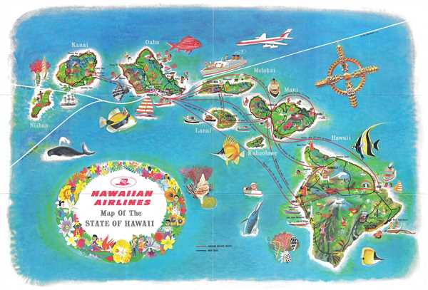
Hawaiian Airlines Map of the State of Hawaii.
1963 (undated) 11 x 16.5 in (27.94 x 41.91 cm) 1 : 31700
1963 (undated) 11 x 16.5 in (27.94 x 41.91 cm) 1 : 31700
Description
This is a 1963 Hawaiian Airlines map of Hawaii. The map depicts the Hawaiian archipelago including the islands of Hawaii, Maui, Kahoolawe, Lanai, Molokai, Oahu, Kauai and Nihau. Beautifully illustrated, an incredibly welcoming impression of the islands is created. Cities and towns are labeled on each of the islands, including Honolulu, Kona, Hilo, and Kahului. Points of interest are illustrated and labeled, such as Pearl Harbor, Waikiki, Hawaii Volcanoes National Park, Mauna Loa, Mauna Kea, and Kilauea Crater. People are depicted swimming, surfing, hunting, dancing, and fishing, as well as other activities. Encircled by various species of fish and a whale, the atmosphere of a tropical paradise is presented, enticing the viewer to patronize Hawaiian Airlines and to discover all of the wonders that Hawaii has to offer.
This map was published Hawaiian Airlines. On the verso, tourist information abounds, with information on flights, Hawaiian Airlines safety record, and the different islands, allowing the reader to decide which island (or islands) to visit.
This map was published Hawaiian Airlines. On the verso, tourist information abounds, with information on flights, Hawaiian Airlines safety record, and the different islands, allowing the reader to decide which island (or islands) to visit.
Condition
Very good. Slight wear along original fold lines. Text on verso.
References
Rumsey 12065.003.