This item has been sold, but you can get on the Waitlist to be notified if another example becomes available, or purchase a digital scan.
1939 Japanese World War II Chart or Map of Hawaii
Hawaii-japanese-1939$500.00

Title
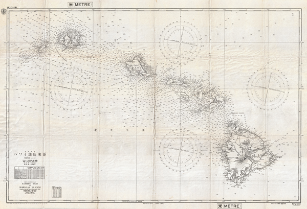
North Pacific Ocean Eastern Part of Hawaiian Islands.
1939 (dated) 27 x 39 in (68.58 x 99.06 cm)
1939 (dated) 27 x 39 in (68.58 x 99.06 cm)
Description
This is a rare and important World War II 1939 Imperial Japanese Navy nautical and aeronautical map / chart of the Hawaiian Islands. The map covers the entire archipelago and the surrounding seas featuring countless depth soundings, four compass tables, and some topographical detail. Like most Japanese nautical charts used during World War II, this map is an amalgam of American and British hydrographic efforts. In this case, the map is cartographically derived from a 1933 United States Naval Chart; however, other dates on the map suggest that it was updated by the Japanese to 1939 – making it very interesting indeed. A close examination of the island of Oahu shows three sites underlined in period red pencil: Honolulu, Honolulu Harbor, and Pearl City (Pearl Harbor). Could this chart have been used to plan or execute the 1941 Pearl Harbor Attack that forced a U.S. hand in World War II? While there is no hard evidence that this is the case, the indirect evidence is suggestive. This chart is a Japanese military issue map of the period. The target areas are highlighted and this chart features both nautical and aeronautical elements. The likelihood, given the underlines and this document's military nature, that this chart or one like it was used to plan or execute the Pearl Harbor Attack is extremely high. This is thus a rare opportunity to own a document that significantly impacted the history of the world. Corresponds to Japanese Nautical Chart no. 2010.
Condition
Very good. Minor wear and toning on original fold lines, especially at fold intersections. A few manuscript marks, as discussed in description. Else clean.