This item has been sold, but you can get on the Waitlist to be notified if another example becomes available, or purchase a digital scan.
1945 U.S. Army Air Forces Aeronautical Chart or Map of the Hawaiian Islands
HawaiianIslands-usaaf-1945$500.00

Title
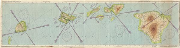
Hawaiian Islands, North Pacific Ocean No. 170.
1945 (dated) 14.5 x 53 in (36.83 x 134.62 cm) 1 : 500000
1945 (dated) 14.5 x 53 in (36.83 x 134.62 cm) 1 : 500000
Description
This is an uncommon 1945 World War II era U.S. Army Air Forces aeronautical chart or map of the Hawaiian Islands in the North Pacific Ocean. It covers the entire archipelago and includes the Hawaiian Islands of Niihau, Kauai, Oahu, Molokai, Lanai, Maui, Kahoolawe and Hawaii. The map is highly detailed, noting important cities, towns, rivers, roads, volcanoes and a host of other hydrographical and topographical features essential for the air pilot.
This chart was prepared for use at night under white, ultra-violet, red and amber lights. Verso includes keys, legends, and other useful information. This chart was prepared at the direction of the Commanding General, Army Air Forces, by the Aeronautical Chart Service, Washington D. C. First issued in 1944, this is the 2nd edition. Chart no. 170.
This chart was prepared for use at night under white, ultra-violet, red and amber lights. Verso includes keys, legends, and other useful information. This chart was prepared at the direction of the Commanding General, Army Air Forces, by the Aeronautical Chart Service, Washington D. C. First issued in 1944, this is the 2nd edition. Chart no. 170.
Condition
Very good. Some wear and along original fold lines. Overall toning and minor spotting at places. Professionally flattened and backed with archival tissue.