This item has been sold, but you can get on the Waitlist to be notified if another example becomes available, or purchase a digital scan.
1950 Joseph Feher Dole Map of Hawaii
HawaiiDolePineappleMap2-feher-1950$225.00

Title
The Dole Map of the Hawaiian Islands.
1950 (dated) 20 x 39 in (50.8 x 99.06 cm) 1 : 800000
1950 (dated) 20 x 39 in (50.8 x 99.06 cm) 1 : 800000
Description
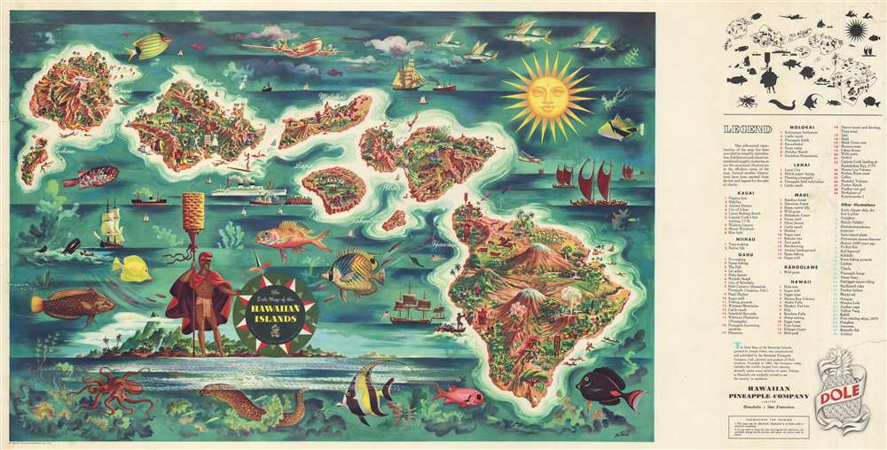
This is a 1950 Joseph Feher pictorial map of the Hawaiian Islands. The map depicts all eight of the major islands in the archipelago from Nihau and Kauai to Hawaii. Myriad illustrations populate the map, with each island's uniqueness coming through thanks to these illustrations. Vignettes celebrating Hawaiian daily life, culture, and history are present, as are sailing ships from every era and even an airliner. Numerous tropical fish surround the archipelago, including a Humuhumunukunukuapuaa and a butterfly fish, along with an octopus and a moray eel. An index to the right of the map details most of these illustrations, although a few are left out.
Census and Publication History
This map was drawn by Joseph Feher and published by the Hawaiian Pineapple Company in 1950.Cartographer
Joseph Feher (1908 - 1987) was a Hungarian born watercolorist active in Hawaii from about 1930 - 1960. Feher fell in love with Hawaiian history and culture and completed a number of pictorial watercolor maps of Hawaii for the Dole Pineapple Company and for United Airlines. For a time Feher also worked as a senior curator for the Honolulu Academy of the Arts where he compiled an encyclopedic history of Hawaii called Hawaii: A Pictorial History. More by this mapmaker...
Condition
Very good. Even overall toning. Closed tears extending two to three inches from the left margin professionally repaired on verso. Blank on verso.
References
Rumsey 8502.000. OCLC 698411183.