This item has been sold, but you can get on the Waitlist to be notified if another example becomes available.
1982 Wright Surfing Map of the Hawaiian Islands
HawaiiSurfing-wright-1982$150.00

Title
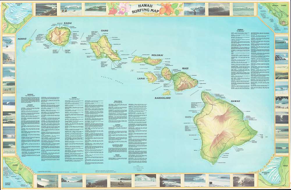
Hawaii Surfing Map.
1982 (dated) 22.25 x 34 in (56.515 x 86.36 cm) 1 : 835000
1982 (dated) 22.25 x 34 in (56.515 x 86.36 cm) 1 : 835000
Description
This is a 1982 Allen B. Wright Jr. surfing map of Hawaii. The map depicts all eight islands in the archipelago with Nihau on the left and Hawaii on the right. Each island is labeled, as are cities and towns on each island, except for Kahoolawe and Nihau. Roads are illustrated as well, including ungraded dirt or jeep trails. Most importantly for this piece is that myriad surfing locales are identified along the coast of the islands, with short descriptions of a large number of them appearing in the lower left corner as well as the upper right, where descriptions of the beaches on the island of Hawaii are situated. The whole is surrounded by a border featuring color photographs of swells and surfers. Four inset maps occupy the four corners and illustrate Hanalei Bay on Kauai, Waikiki and the North Shore on Oahu, and Honolua Bay on Maui. The surfing at Hanalei Bay is the best on Kauai, while Honolua Bay, if the surf is right, can provide some of the best surfing around. Waimea Bay and Pipeline on the North Shore, however, are world famous, while the North Shore has some of the world's finest beaches and bays.
Publication History and Census
This map was created by Allen B. Wright Jr. and published in 1982. We are aware of three examples present in the institutional collections of the Library of Congress, the University of California, Los Angeles, and the University of Hawaii at Manoa. We are unaware of any other example entering the private market.Condition
Very good. Even overall toning. Light creasing. Closed tear extending 1.25 inches into printed area from right side professionally repaired on verso. Blank on verso.
References
OCLC 907684503.