This item has been sold, but you can get on the Waitlist to be notified if another example becomes available, or purchase a digital scan.
1731 D'Anville Map of Hispaniola or Santo Domingo (Haiti / Dominican Republic)
Hayti-anville-1731$175.00

Title
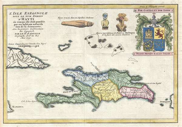
L'Isle Espagnole Sous le Nom Indien d'Hayti où comme elle étoit possédée par ses habitans naturels lor de la découverte, Avec les prémiers Etablissements des Espagnols.
1731 (dated) 8 x 12 in (20.32 x 30.48 cm) 1 : 3400000
1731 (dated) 8 x 12 in (20.32 x 30.48 cm) 1 : 3400000
Description
This is a beautiful hand colored 1731 Jean-Baptiste Bourguinon d'Anville map of Haiti. This map depicts the island of Hispaniola as it may have been before Christopher Columbus made is trans-Atlantic voyage. Hispaniola is divided into five different 'states,' which d'Anville explains is how the island was owned by its indigenous inhabitants before the arrival of the Spanish. D'Anville, however, did deem it appropriate to include the sites of the first Spanish settlements, including the first site of San Domingo and Puerto Real. D'Anville also included three sketches of indigenous art, including Zemis. A Zemi was a religious object of the Taíno people who lived in the Caribbean before the arrival of the Europeans. Sadly they have since died out or migrated off the island. In the upper right corner is a depiction of the coat of arms of Christopher Columbus, the first recorded European to discover the New World.
D'Anville was truly the first modern cartographer. Unlike many of his contemporaries and predecessors, d'Anville based his maps on intense study and research. His maps were also the most accurate and comprehensive of the period. He also left unknown areas blank and noted doubtful information as such on his maps. This map was drawn by d'Anville and engraved by Leparmantier. It was published by Pierre-Francois-Xavier de Charlevoix in his volume Histoire de l'Isle Espagnole ou de S. Domingue, which was published in Paris in 1731 by Pralard.
D'Anville was truly the first modern cartographer. Unlike many of his contemporaries and predecessors, d'Anville based his maps on intense study and research. His maps were also the most accurate and comprehensive of the period. He also left unknown areas blank and noted doubtful information as such on his maps. This map was drawn by d'Anville and engraved by Leparmantier. It was published by Pierre-Francois-Xavier de Charlevoix in his volume Histoire de l'Isle Espagnole ou de S. Domingue, which was published in Paris in 1731 by Pralard.
Cartographer
Jean Baptiste Bourguignon d'Anville (1697 - 1782) was perhaps the most important and prolific cartographer of the 18th century. D'Anville's passion for cartography manifested during his school years when he amused himself by composing maps for Latin texts. There is a preserved manuscript dating to 1712, Graecia Vetus, which may be his earliest surviving map - he was only 15 when he drew it. He would retain an interest in the cartography of antiquity throughout his long career and published numerous atlases to focusing on the ancient world. At twenty-two D'Anville, sponsored by the Duke of Orleans, was appointed Geographer to the King of France. As both a cartographer and a geographer, he instituted a reform in the general practice of cartography. Unlike most period cartographers, D'Anville did not rely exclusively on earlier maps to inform his work, rather he based his maps on intense study and research. His maps were thus the most accurate and comprehensive of his period - truly the first modern maps. Thomas Basset and Philip Porter write: "It was because of D'Anville's resolve to depict only those features which could be proven to be true that his maps are often said to represent a scientific reformation in cartography." (The Journal of African History, Vol. 32, No. 3 (1991), pp. 367-413). In 1754, when D'Anville turned 57 and had reached the height of his career, he was elected to the Academie des Inscriptions. Later, at 76, following the death of Philippe Buache, D'Anville was appointed to both of the coveted positions Buache held: Premier Geographe du Roi, and Adjoint-Geographer of the Academie des Sciences. During his long career D'Anville published some 211 maps as well as 78 treatises on geography. D'Anville's vast reference library, consisting of over 9000 volumes, was acquired by the French government in 1779 and became the basis of the Depot Geographique - though D'Anville retained physical possession his death in 1782. Remarkably almost all of D'Anville's maps were produced by his own hand. His published maps, most of which were engraved by Guillaume de la Haye, are known to be near exact reproductions of D'Anville' manuscripts. The borders as well as the decorative cartouche work present on many of his maps were produced by his brother Hubert-Francois Bourguignon Gravelot. The work of D'Anville thus marked a transitional point in the history of cartography and opened the way to the maps of English cartographers Cary, Thomson and Pinkerton in the early 19th century. More by this mapmaker...
Source
Charlevoix, Pierre François Xavier de, Histoire de l'Isle Espagnole ou de S. Domingue (Amsterdam: Pralard) 1733.
Condition
Very good. Slight transferrance. Blank on verso.
References
OCLC 829552990.