This item has been sold, but you can get on the Waitlist to be notified if another example becomes available, or purchase a digital scan.
1782 Bocage Map of Hellespont, Ancient Greece
Hellespont-bocage-1791$87.50

Title
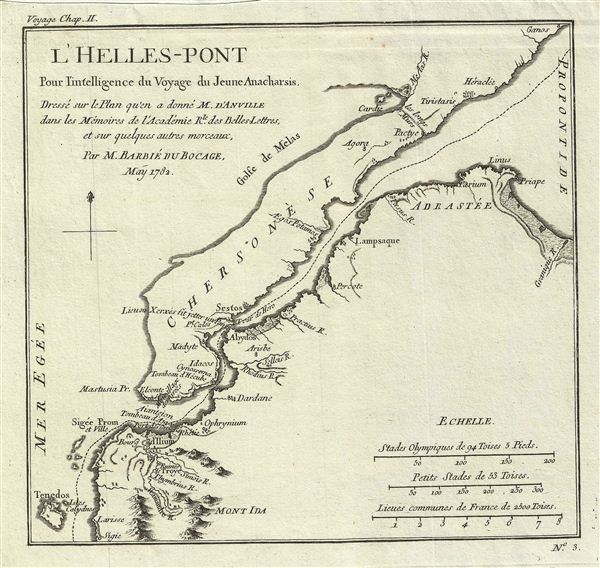
l'Helles-Pont Pour l'intelligence du Voyage du Jeune Anacharsis.
1782 (dated) 8 x 8.5 in (20.32 x 21.59 cm)
1782 (dated) 8 x 8.5 in (20.32 x 21.59 cm)
Description
This is a fascinating 1782 map of the Hellespont (Dardanelles) in antiquity. Cartographically based on an earlier chart by D'Anville, Barbie de Bocage's map covers the narrow strait connecting the Aegean Sea and the Sea of Marmara. Referring to the account of the Greek historian Herodotus, Bocage identifies the 'Lieu ou Xerxes fit jetter un Pont' (place where Xerxes threw his bridge). According to The Histories, Xerxes, the Persian emperor, built two pontoon bridges, later known as Xerxes' Pontoon Bridges, at Abydos to cross the strait from Asia to Thrace. The strait is also mentioned in the mythological tale of Hero and Leander where Leander crossed the strait to his beloved Hero. Prepared by M. Barbie de Bocage in 1782 to illustrate the Travels of Anacharsis.
Anacharsis was a Scythian philosopher who travelled from his homeland on the northern shores of the Black Sea to Athens in the early 6th century BCe. Apparently he made a great impression on the Greeks, who considered him a forthright, outspoken 'barbarian. He is considered a forerunner of the Cynics.
Anacharsis was a Scythian philosopher who travelled from his homeland on the northern shores of the Black Sea to Athens in the early 6th century BCe. Apparently he made a great impression on the Greeks, who considered him a forthright, outspoken 'barbarian. He is considered a forerunner of the Cynics.
Cartographer
Jean Denis Barbie du Bocage (1760 - 1825) and his son Jean-Guillaume Barbie du Bocage (1795 - 1848) were French cartographers and cosmographers active in Paris during late 18th and early 19th centuries. The elder Barbie du Bocage, Jean Denis, was trained as a cartographer and engraver in the workshops of mapmaking legend J. B. B. d'Anville. At some point Jean Denis held the post of Royal Librarian of France and it was through is associations with d'Anville that the d'Anville collection of nearly 9000 maps was acquired by French Ministry of Foreign Affairs. The younger Barbie du Bocage, Jean-Guillaume, acquired a position shortly afterwards at the Ministry of Foreign Affairs and, in time, became its head, with the title of Geographe du Ministere des Affaires Etrangeres. More by this mapmaker...
Source
Barbie du Bocage, J. D., Recueil de Cartes Geographiques Plans, Vues, et Medailles de l'Ancienne Grece, Reelatifs au Voyage du Jeune Anacharsis., (Paris, Chez Sanson et Compagnie), 1791.
Condition
Very good. Original platemark visible. Blank on verso. Dark clean impression.