This item has been sold, but you can get on the Waitlist to be notified if another example becomes available, or purchase a digital scan.
1815 Blankensteiner Blueback Nautical Chart or Map: Helsinki to St. Petersburg
HelsinkiStPetersburg-blankensteiner-1815$600.00

Title
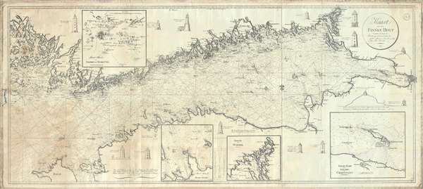
Kaart over den Finske Bugt, samlet og reduceret efter de nyeste udkomne svenske og rusiske Söe-Kaarter. / Map of the Gulf of Finland, based on the most recent charts, both Swedish and Russian.
1815 (dated) 25.5 x 56.5 in (64.77 x 143.51 cm) 1 : 350000
1815 (dated) 25.5 x 56.5 in (64.77 x 143.51 cm) 1 : 350000
Description
A stunning 1815 Danish nautical chart or maritime map of the Gulf of Finland from, roughly Helsinki, Finland to St. Petersburg, Russia. This chart was published in Denmark by Johan Georg Blankensteiner. It covers the entire Gulf of Finland with as well as some of the surrounding seas. There are four inset charts and illustrations of 14 lighthouses as well as rhumb lines and depth soundings throughout.
Blueback Charts
Blueback nautical charts began appearing in London in the late 18th century. Bluebacks, as they came to be called, were privately published large format nautical charts known for their distinctive blue paper backing. The backing, a commonly available blue manila paper traditionally used by publishers to warp unbound pamphlets, was adopted as a practical way to reinforce the low-quality paper used by private chart publishers in an effort to cut costs. The earliest known blueback charts include a 1760 chart issued by Mount and Page, and a 1787 chart issued by Robert Sayer. The tradition took off in the early 19th century, when British publishers like John Hamilton Moore, Robert Blachford, James Imray, William Heather, John William Norie, Charles Wilson, David Steel, R. H. Laurie, and John Hobbs, among others, rose to dominate the chart trade. Bluebacks became so popular that the convention was embraced by chartmakers outside of England, including Americans Edmund March Blunt and George Eldridge, as well as Scandinavian, French, German, Russian, and Spanish chartmakers. Blueback charts remained popular until the late 19th century, when government subsidized organizations like the British Admiralty Hydrographic Office and the United States Coast Survey, began issuing their own superior charts on high quality paper that did not require reinforcement.Publication History and Census
This chart is exceedingly scarce and we have been able to identify but one other example, at the Bibliothèque Sainte Geneviève, Paris. Owned jointly by Geographicus and Vetus Carta.Cartographer
Johan Georg Blankensteiner (February 22, 1753 – May 8, 1835) was a German-Danish publisher of nautical charts, instrument maker, and nautical supplier based in Copenhagen, Denmark. Blankensteiner was born in Oberammergau, Bavaria. He moved to Copenhagen sometime around 1780. Ion 1791 he established a corner toy shop specializing in German toys at 69 Købmagergade. It seems that, from the beginning, the firm also sold nautical charts and navigation instruments. In 1792 he published a catalog of various maps and atlases. By 1803 they were a well-established nautical warehouse both producing their own charts and offering foreign charts. Sometime in the 1830s Carl August Blankensteiner (1809 - 1870), Johan Georg's son, joins the business and the firm is renamed Blankensteiner and Sons. After his death the firm continued to trade under Carl August. In 1844 the firm received a royal privilege, a kind of early copyright, by the Danish King Christian VIII, as chart sellers and instrument makers. At this time, they also relocated Toldbodvejen 48 (currently Esplanade) at the corner of Amaliegade. In 1860, the firm was sold to T. Baagøe, who traded as Blankensteiners Efterfølgers (Blankensteiner's Successors). Various owners followed, including August Busck, William Jensen, Cc. Peterson, and Christian Bønnelycke. The business continued to sell charts until about 2000, when it finally closed. As a side note, the toy side of the business was also quite successful and numbered the playwright and novelist Hans Christian Andersen among its clients. More by this mapmaker...
Condition
Good. A few verso reinforcements. Waterstain lower left quadrant.
References
OCLC 763099416.