This item has been sold, but you can get on the Waitlist to be notified if another example becomes available, or purchase a digital scan.
1806 Wustinger World Map in Two Hemispheres
Hemispheres-wustinger-1806$250.00

Title
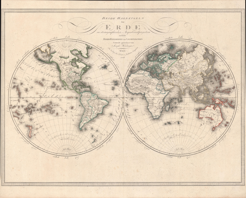
Beide Halbkugeln der Erde : in stereographischer Aequatorialprojection nach des Herrn Freiherrn von Liechtenstern.
1806 (dated) 18.75 x 26 in (47.625 x 66.04 cm)
1806 (dated) 18.75 x 26 in (47.625 x 66.04 cm)
Description
An elegant 1806 world map in two hemispheres by Joseph Wüstinger with outline hand-coloring. It depicts the world with recent discoveries incorporated, including the voyages of Cook and Vancouver.
It is particularly detailed in the documentation of Pacific islands, which are exaggerated in size to highlight their importance, as are islands in the South Atlantic and Indian Ocean. In the wake of the voyages of Carteret, Cook, and others, contemporary viewers would have been especially interested in these islands.
Greenland is illustrated as possibly connected to Canada by a land bridge, a notion dispelled the following decade with John Ross' 1818 First Arctic Expedition. The map of the Americas would change considerably in the following years as Spain's colonial empire collapsed and independent nation-states emerged.
A Closer Look
The world is illustrated in two hemispheres with the latest geographic information included, hand-colored outlines of countries and continents, and finely engraved text. As was common for the time, Antarctica is not included but the outline of a coast south of the Sandwich Islands is drawn with the note 'ice field stumbled upon by Cook in 1770.'It is particularly detailed in the documentation of Pacific islands, which are exaggerated in size to highlight their importance, as are islands in the South Atlantic and Indian Ocean. In the wake of the voyages of Carteret, Cook, and others, contemporary viewers would have been especially interested in these islands.
Greenland is illustrated as possibly connected to Canada by a land bridge, a notion dispelled the following decade with John Ross' 1818 First Arctic Expedition. The map of the Americas would change considerably in the following years as Spain's colonial empire collapsed and independent nation-states emerged.
Publication History and Census
This map was prepared by Joseph Wüstinger, about whom little information is available, and published by Kunst und Industrie Comptoirs in Vienna in 1806. It is based on the geographical work of Joseph Marx von Liechtenstern, referred to in the title. The map is quite rare, and is only listed among the holdings of Yale University and four institutions in Germany and France.CartographerS
Kunst und Industrie Comptoirs (c. 1801 - 1814) was a Vienna-based publisher of musical scores, most notably the first editions of many Beethoven works between 1802 and 1808. The firm also was a map dealer and publisher. More by this mapmaker...
Joseph Marx Freyherrn von Liechtenstern (February 12, 1765 - October 10, 1828) was an Austrian nobleman, geographer, and statistician. Coming from an elite family, he was well-educated, studying law before going into government service. He maintained a lifelong passion for geography, statistics, and comparative administration between states (political science avant le mot), and in 1790 founded the Vienna Kosmographische Institut ('Statistical Institute'). The upheavals of the era hampered the group's work; nonetheless, it did produce a steady stream of publications on history and geography, and promoted the use of statistics in public administration. Among other works, in contributed to and completed the influential 1805 Atlas Des Österreichischen Kaiserthums. Learn More...
Condition
Very good. Even toning. Light foxing. Margins trimmed closely on the sides.
References
OCLC 1152932947.